Blue Raster is pleased to announce a new release of the REL Midwest’s EdMaps, an interactive web mapping application that helps education stakeholders think spatially about education issues affecting their communities.
Initially launched in January 2014, EdMaps enables users to visualize and analyze complex, geographically linked education data through easy-to-use story maps. The updated application features three additional maps, as well as a new custom maps tool and tutorial video. It also incorporates recently released public school, private school, and district-level school data from the U.S. Department of Education’s National Center for Education Statistics (NCES).
The new story maps look at:
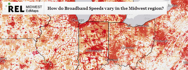
- School access to broadband Internet – Currently fewer than 40 percent of American public schools have high-speed Internet in their classrooms. President Obama stated in a ConnectED conference that, “In a country where we expect free Wi-Fi with our coffee, the least we can do is expect that our schools are properly wired.”
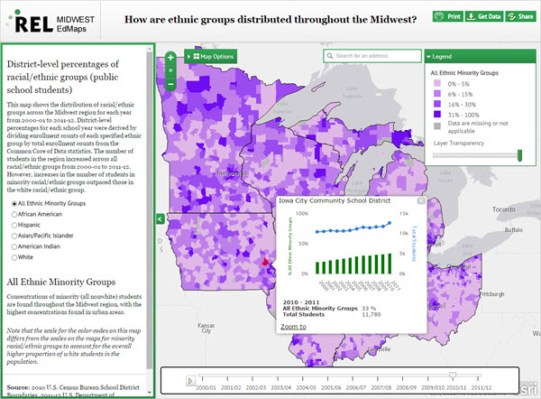
- Historic district-level ethnicity – Users can view the distribution of racial/ethnic groups across the Midwest region from 2000/01 – 2011/12.
- Priority and Focus schools – Visualize locations of low-performing schools designated as Priority or Focus schools.
The data and story maps in the application address the Rel Midwest’s four main priority areas of college and career readiness, early childhood education, educator effectiveness, and low-performing schools. Blue Raster built the application using the JavaScript API, ArcGIS Desktop, and ArcGIS for Server. Future releases of the application will feature additional story maps including a look at Advanced Placement (AP) courses in the Midwest region using the Esri Map Journal Builder.
Check out the application today by visiting EdMaps.