We will help you get the most out of ArcGIS Online
Blue Raster offers ArcGIS Accelerate solutions to help users quickly and easily tap into the power of this game-changing platform. We apply our extensive technical experience and comprehensive knowledge to help you configure, express, and share your data via accurate maps and innovative applications, cohesively through the fabric of ArcGIS Enterprise, ArcGIS Online, ArcGIS Pro, and ArcMap.
We help clients establish themselves with ArcGIS technology to quickly and easily and help them understand the best practices of mapping and data management/standardization. We assess what organizations seek to do with their data and where they can benefit from ArcGIS services.
Through this process, you will be able to:

We offer custom HTML5 programming for tailored applications and can integrate other visual media — photos and videos — from the platforms you already use. Through it all, we will be there to help you make your mapping work easy, fast, and impactful.
Blue Raster is the expert in using ArcGIS Enterprise and ArcGIS Online to create and share maps fast. We are pros at helping you tell a visually rich and compelling story with your data and other media. Your data will help support this story in an approachable fashion.
We have transformed the way our customers share their stories using this powerful, secure cloud-based platform.
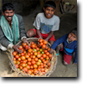 Blue Raster helped the World Bank establish its innovative GeoResults tool that documents, contextualizes, and graphically shares the on-the-ground results of its activities around the world. For the first time, projects are more than just dots on the map.
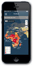 We worked with USAID to create the DHS Program mobile app, providing data on vaccination, childhood mortality, nutrition, and 22 other indicators to users in more than 90 countries. In much of the world, mobile devices outnumber traditional desktops in terms of how users consume information.
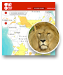 We collaborated with the International Union for Conservation of Nature (IUCN) to create the IUCN Red List Mapper, sharing the story behind threatened species and protected areas around the world. IUCN is the international authority on animal ranges, and the Cloud offerings of ArcGIS Online made it possible to share incredibly large volumes of data.
Teaming up with Blue Raster and ArcGIS technology will help you capitalize on the inherent value of your data and information. Dynamically develop and express the stories you want to share with our quick and hassle-free approach. To learn more about the ArcGIS Accelerate program, call us at (703) 875-0911 or submit the form below: