In 2015, United Nations Member States adopted the 2030 Agenda for Sustainable Development, a shared blueprint for global peace and prosperity now and into the future. Within the core of this agenda are 17 Sustainable Development Goals (SDG) which call all countries to action in a global partnership.
Goal 15 of the Sustainable Development Goals outlines a plan to protect, restore and promote sustainable use of terrestrial ecosystems, sustainably manage forests, combat desertification, and halt and reverse land degradation and biodiversity loss
As part of its initiatives in West Africa, the MIT Media Lab partnered with the Biospheric Sciences Lab at NASA Goddard Space Flight Center and Blue Raster to develop a desktop-based geospatial toolkit for calculating and reporting key indicators within Goal 15 of the SDGs. These key indicators are:
- Forest area as a proportion of total land area
- Proportion of important sites for terrestrial and freshwater biodiversity that are covered by protected areas, by ecosystem type.
- Coverage by protected areas of important sites for mountain biodiversity.
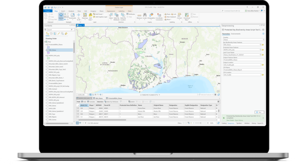
Blue Raster developed these tools in a custom toolbox using ArcGIS Pro and the ArcGIS Python site package, ArcPy to calculate the key indicators for countries in the West African region namely: Nigeria, Ghana, Liberia, Togo, Benin, Guinea, and Botswana. The tool leverages remotely sensed imagery and standardized datasets to inform and provide decision making support to West African stakeholders as well as stakeholders within the academic community supporting the UN’s Sustainable Development agenda.
Blue Raster is long time partner of the MIT Media Lab and had previously partnered with the MIT Media Lab and Green Keeper Africa to develop the Lake Nokoué Environmental Observatory application, an online mapping that provides the public with current and historic information about water quality and invasive species in Lake Nokoué. The online observatory and decision support tool utilizes satellite, aerial and ground data to map water quality readings, as well as the location of water hyacinth and a fish farming practice known as “acadja” over time.
- Posted in
- ArcGIS Pro
- ArcGIS Desktop
- Conservation
- Development
- Economic Development
- Forest
- SDG
- Sustainable Development Goals
Related Posts
- GFW Pro: Managing Deforestation Risk in Commodity Supply Chains
- Forest Products Without Compromise
- Sustainable World Conference in Geneva: Collaborating for a better world
- Blue Raster Pioneering Imagery Management Technology and Delivery Workflows with ArcGIS
- Improving Deforestation Risk Management in Commodity Supply Chain