Since 1953, Natural Lands has dedicated time, energy, and funds to protecting open spaces and promoting biodiversity in Pennsylvania and New Jersey. The nonprofit has worked tirelessly to preserve the two states' forests, wetlands, meadows, and farmlands so that future generations may appreciate and enjoy them for years to come. As a leading conservation organization that uses science-based approaches to protect some of the most valuable environmental areas, Natural Lands is no newcomer to using GIS to track acquired land, manage ecosystems, and engage communities in its conservation efforts.
Due to the ever-evolving capabilities of GIS, Natural Lands knew it would benefit from a partner who could help navigate and streamline its GIS operations and upgrade them to a more powerful GIS platform. Blue Raster was the perfect match.
Introducing ArcGIS Enterprise to Natural Lands
In order to enhance the nonprofit’s efforts, Blue Raster needed to first streamline its GIS operations. To do so, our team reviewed Natural Lands’ existing GIS architecture, datasets, and services, and proposed a migration strategy to ArcGIS Enterprise 10.9.1.
ArcGIS Enterprise was chosen for Natural Lands because of its:
- Advanced spatial analysis tools
- Streamlined data management capabilities
- Ability to easily manage and analyze data related to land acquisition, ecological assessments, and restoration projects
- Ability to communicate conservation work to the public, helping to raise awareness and build support for their efforts

Kicking Off the Migration Process
Phase one of Natural Lands’ technology modernization began with our team establishing a Bastion host with ArcGIS Pro for Enterprise and Geodatabase Administration and proposing a strategy for backing up and exporting existing SQL Server databases and file geodatabases on the nonprofit’s existing server. This ensured a smooth and seamless migration experience, with minimal disruption to Natural Lands’ daily operations.
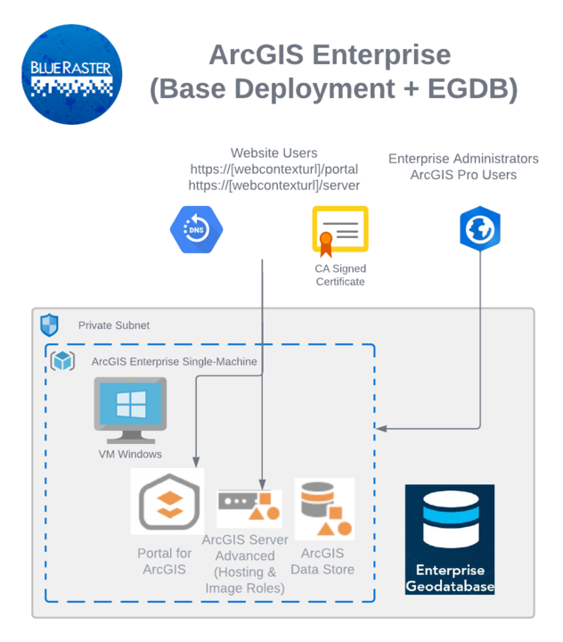
Once the migration was finished, our senior DevOps engineer, Scott Geistmann, installed, configured, and administered ArcGIS Enterprise Server Deployment 10.9.1, along with ArcGIS Portal, federated ArcGIS Server in a Hosting Role with ArcGIS Portal, and ArcGIS Data Store. Our team also set up Azure SQL Database Server and installed ArcGIS Pro, while advising on initial portal settings and configurations and proposing Azure Machine specifications. With these server improvements, Natural Lands was able to:
- See an increase in performance for processors and storage capacity
- Easily use the latest versions of ArcGIS Enterprise and ArcGIS Pro
- Handle an increased workload and userbase
- Access better support options—such as remote monitoring and management—with fewer maintenance requirements
Expert Guidance, Easy User Experience
Blue Raster’s professional support didn’t end with the successful migration to ArcGIS Enterprise. As a trusted GIS solutions provider, we delivered post-migration support and training to Natural Lands to guarantee everyone on the nonprofit’s team felt comfortable and informed when it came to the new enhancements. The training covered a range of topics, which included:
- Managing the ArcGIS Enterprise Server
- Overseeing Azure Cloud services and assets
- Updating and publishing feature and image services
- Administering ArcGIS Portal accounts—including user roles and permissions
With this new platform, Natural Lands can now access heightened GIS capabilities, making it easier for the nonprofit to manage their data and share it with the public efficiently and accurately. "We couldn't be more pleased with our ArcGIS Enterprise installation by Blue Raster. They guided us through the implementation process and provided top-notch support along the way,” shares Megan Boatright, GIS program director, Natural Lands. “Blue Raster’s attention to detail and commitment to meeting our needs ensured a successful outcome—plus, the ability to access our geospatial data and tools from anywhere has been a game-changer."
Be On the Cutting Edge of GIS Capabilities
See how Blue Raster can help you surpass your competition with customized GIS solutions.
Related Posts
- Esri ArcGIS Cloud Specialty: Elevating our clients’ GIS capabilities to the sky
- Blue Raster Pioneering Imagery Management Technology and Delivery Workflows with ArcGIS
- What Are the Discovery, Execution, and Maintenance Phases of ArcGIS Enterprise Cloud Migration?
- Celebrating ArcGIS Enterprise Implementation with Blue Raster’s Scott Geistmann
- Virtualizing ArcGIS in the Cloud
