Our Work

Blue Raster helps you tell your story through interactive
mapping technology. Make your message clear, exciting,
and user-friendly for both mobile and web platforms.

Land Use

Blue Raster Pioneering Imagery Management Technology and Delivery Workflows with ArcGIS

Many organizations prioritize the accessibility of imagery and image-derived products for visualization and analysis among both internal and external users. As such, efficient  management and delivery workflows are crucial for these organizations to fully harness the power of spatial data and maximize their product impact. Use cases for aerial images and raster data include land cover classification, urban planning, natural resource management, emergency response and disaster management, precision agriculture and conservation, environmental monitoring and change detection/climate change analysis.

Blue Raster specializes in utilizing the robust capabilities of GIS and cloud services to facilitate the seamless assembly, analysis, management and dissemination of multiresolution imagery, and raster data from different sources and timeframes. Our expertise helps organizations enhance their spatial data management and analysis capabilities.

Employing ArcGIS for Imagery Hosting, Analysis & Management

Empowered by cutting-edge technology, Blue Raster excels in tapping into the full potential of ArcGIS for image hosting, analysis, and delivery workflows across ArcGIS Enterprise, ArcGIS Pro, and ArcGIS Online. With ArcGIS Image Server and ArcGIS Image for ArcGIS Online, we enable organizations to host and conduct dynamic imagery analysis on an unprecedented scale.

The scalability and performance of ArcGIS Image Server redefines the boundaries of what is achievable in geospatial analytics. Additionally, by integrating imagery into the ArcGIS Online platform, organizations can create compelling and informative maps that facilitate a deeper understanding of their spatial data.

Providing On-Demand Imagery Delivery Services

We specialize in providing swift, on-demand collection and smooth delivery of imagery through versatile means including API keys, custom widgets, online user interfaces, and application plugins. Our expertise ensures that you have the necessary tools and support to cater to diverse requirements and preferences.

Whether you need quick access to specific imagery, or a tailored solution embedded within your applications, Blue Raster stands ready to assist, offering a range of flexible and efficient options to meet your unique needs.

Furthermore, we recognize the importance of seamless delivery workflows in ensuring timely access to critical imagery resources. Our solutions are designed to optimize delivery pipelines, minimizing latency and maximizing efficiency. Whether it's delivering imagery to remote field teams or integrating seamlessly with existing systems, we prioritize speed, reliability, and scalability to meet the dynamic needs of our clients.

Our commitment to innovation extends beyond just technology; it's ingrained in our culture. We're constantly exploring new ways to push the boundaries of what's possible, whether it's through advancements in artificial intelligence, cloud computing, or data visualization. By staying at the forefront of technological innovation, we empower our clients to stay ahead of the curve and achieve their objectives with confidence. Our teams of professionals are here to assist you in developing and deploying your delivery workflows.

Pioneering Collaborative Cloud-Based Imagery Management

For over a decade, Blue Raster has been working with clients and partners to deliver large volumes of imagery to support various geospatial workflows. Our cloud specialty has opened new frontiers for collaborative  management. Maximizing the cloud's scalability, organizations can now store, share, and analyze vast amounts of data in real-time. This not only streamlines internal processes but also facilitates effortless collaboration with external stakeholders.

Across the globe, our clients and partners are employing our services to manage and deliver their imagery to support their projects and organizational goals. Here are some examples:

Learn more about our work here

Contact Us

  • This field is for validation purposes and should be left unchanged.


New Features in the LEARN Tool Expand Functionality for Assessing GHG Emissions from Land Use

As the effects of a warming climate become more apparent, it’s increasingly important to consider ways to mitigate the impact of greenhouse gases on the atmosphere. Forests play a key role in the climate crisis, as about a third of human emitted greenhouse gases are sequestered in trees and forests. Analyzing the impact these forests and tress have using land use and land cover change data is a great way for municipalities to get a read on the effects of greenhouse gas emissions in their own communities.

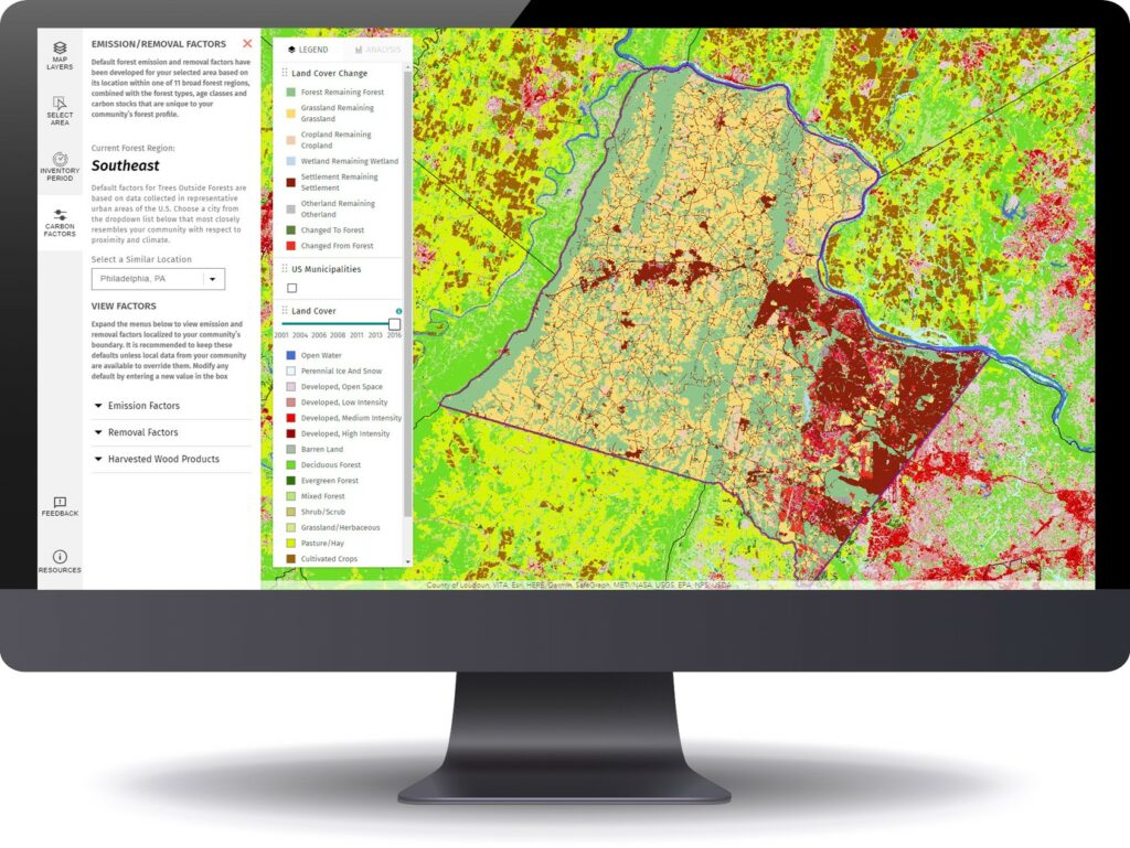
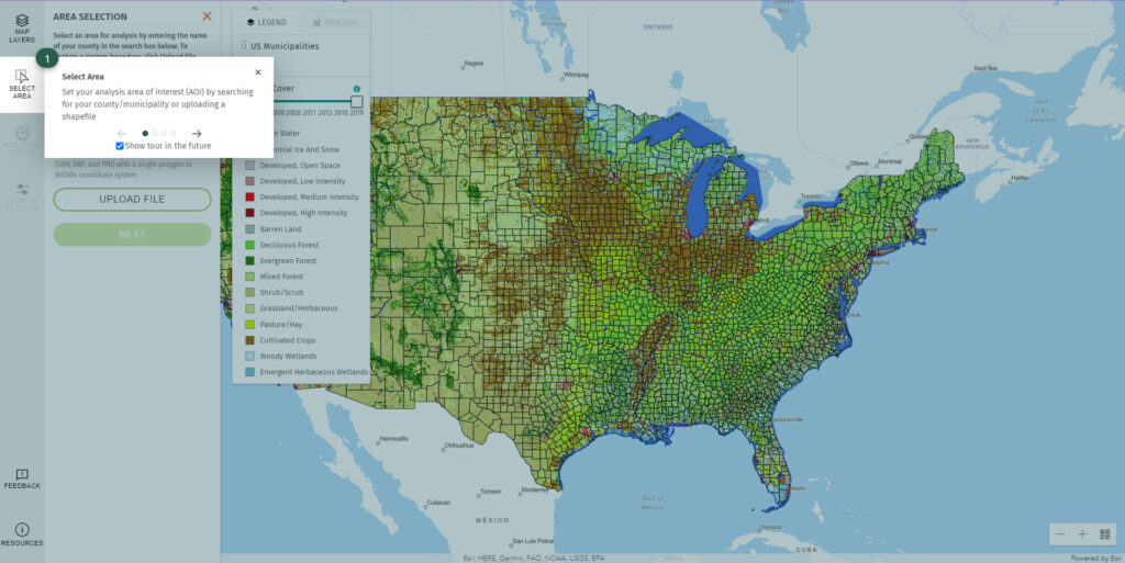
LEARN Tool ScreenShot 6

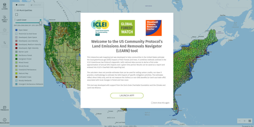
Blue Raster is pleased to release the new build for the LEARN (Land Emissions and Removals Navigator) Tool. Built in partnership with Local Governments for Sustainability (ICLEI) and the World Resources Institute (WRI), the LEARN Tool allows for community inventorying of the effects of land use change on greenhouse gas emissions. This tool empowers policy makers, local governments, and community members to make informed decisions on environmental and climate policy.  Blue Raster developed the LEARN Tool to address a significant gap in existing carbon accounting methods. Traditionally, previously analyses have focused on measuring their emissions from energy and transportation sectors, while the emissions and removals from land-use change and forestry have been overlooked. However, these land-based emissions and removals are responsible for a significant proportion of the carbon footprint, particularly in rural areas.

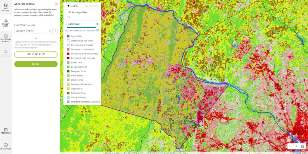
LEARN Tool ScreenShot 1

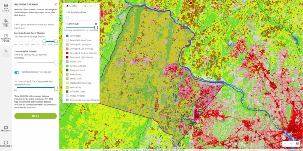
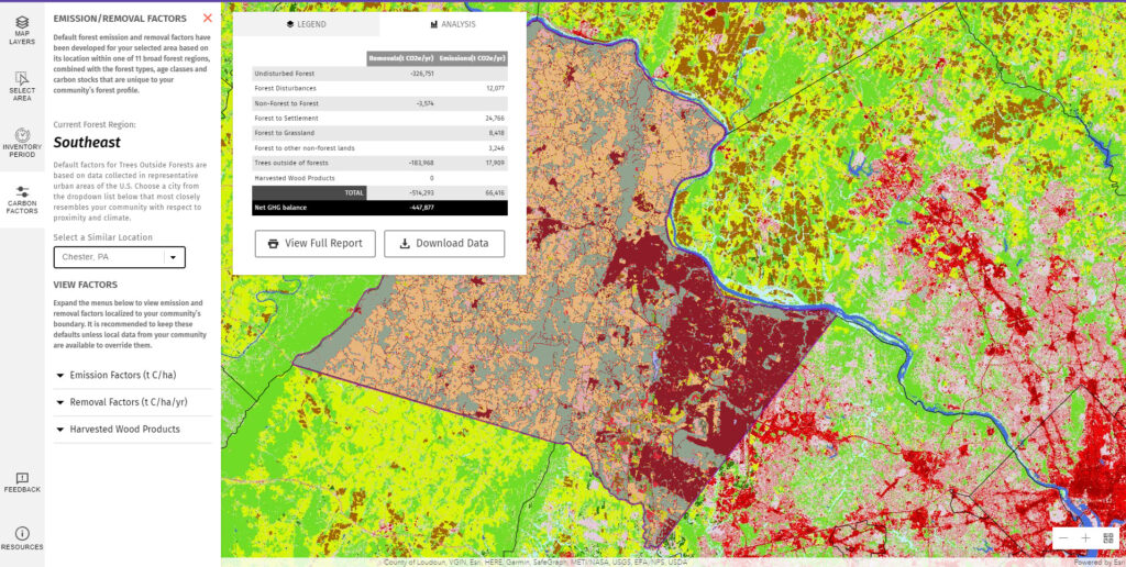
The LEARN Tool simplifies the process of assessing a community's net greenhouse gas balance. Users can quickly select their area of interest by searching for a municipality name or uploading their own shapefile. With intuitive sliders, users can configure their desired land cover and tree canopy data and choose data for forest and land cover change between 2001 and 2019, as well as data for trees outside of forests for the selected time frame. The analysis is generated for the chosen location and time frame, and users can compare their results against other cities and municipalities. The tool provides emission factors, removal factors, and harvested wood products as view factors for the selected comparison area, with the option to download the results as a PDF or CSV file.

The latest version of the LEARN Tool comes packed with new features that improve its functionality. Users now have access to 1m Tree Canopy Data within the Chesapeake Bay Watershed, courtesy of the Chesapeake Bay Program and Chesapeake Conservancy, providing users with valuable insights into how trees and forests impact greenhouse gas inventories. The inventory period configuration screen has also been upgraded with new toggle widgets, offering users greater flexibility in selecting between 30m and 1m data in their analyses. These new features enhance the user experience and expand the tool's capabilities, making it even more valuable for communities looking to reduce their carbon footprint.

Blue Raster is excited to roll out this tool in its final form to benefit communities across the country.


Software used: ArcGIS Enterprise, ArcGIS Image Server, Esri JavaScript API

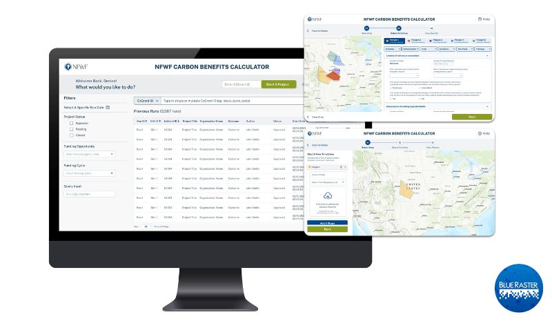
National Fish and Wildlife Foundation Carbon Benefits Calculator

Most of our daily activities create greenhouse gas emissions which exacerbate climate change. Organizations like the National Fish and Wildlife Foundation (NFWF) spearhead efforts to mitigate these negative impacts by funding initiatives that offset emissions and create a greener earth. Blue Raster partnered with NFWF to create a robust Carbon Benefits Calculator. This tool estimates and visualizes the carbon impact of past and planned conservation efforts, restoration, and improved land management activities of NFWF.

NFWF Carbon Benefits Tool

NFWF wanted to innovate and optimize their existing in-house carbon calculator tool that was hosted in Excel. Blue Raster understands the need for a spatially explicit, robust tool that provides real-time calculations and eliminates hard-coded values to improve usability and usefulness. Additionally, this new tool enables NFWF to assess activities in various locations over different time series quickly and easily.

Our team created a web application backed by geoprocessing services in Python scripts. The tool allows a user to upload a spatial polygon for an area of interest to calculate carbon benefits, expanding the previous functionality that only allowed analysis at the county level. These calculations are done with python logic and geoprocessing services that are uploaded to ArcGIS Enterprise. Converting the tool from a spreadsheet-based calculator to a real-time and streamlined web application allowed for faster, easier, and more comparable results.

This tool uses various raster datasets including national land cover and carbon stocks to calculate the different properties and values such as climate, location, size, carbon stock, and land cover of the user submitted area of interest. Then, the tool automatically takes those values from the raster data and calculates the carbon benefits that would result from the selected project. NFWF can use this tool to estimate the carbon benefits of various projects and events such as invasive species clearing, crop and livestock use, thinning, fires, land transformations, over a 30-year period.

Previously, Blue Raster built out the Where We Work web map for NFWF to help illustrate the extensive geographic reach of their mission and impact of their conservation programs. Also, we built a proposal reviewer application and aided in NFWF's ArcGIS Enterprise installation.

We are excited to continue our collaborative efforts and work with a long-time partner by supporting NFWF with the Carbon Benefits Calculator and ongoing conservation efforts.

Ready to find out more?

We are excited to be a part of another non-profit's ongoing conservation and restoration efforts! Contact us today to learn how we can help your organization.

Non_Profit

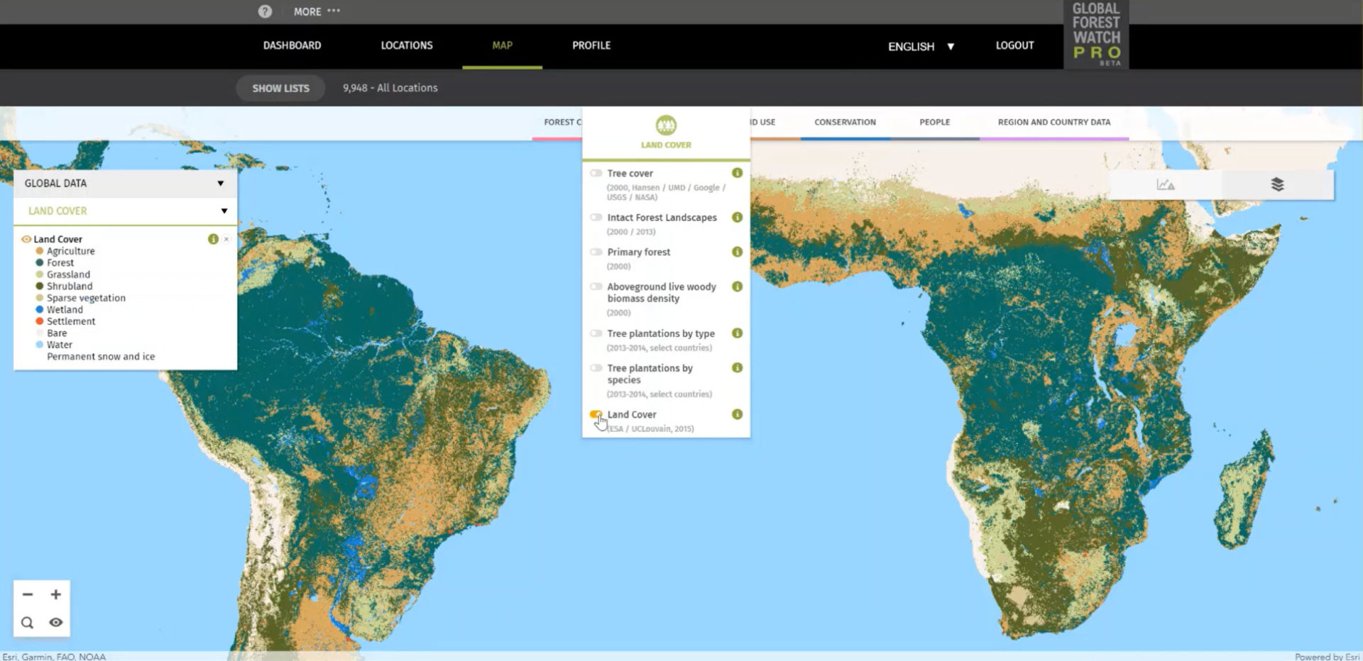
Improving Deforestation Risk Management in Commodity Supply Chain

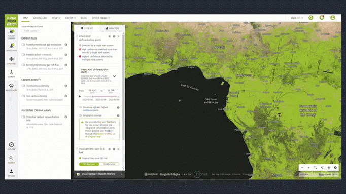
Blue Raster developed Global Forest Watch Pro, a decision support tool that empowers companies to monitor their supply chains for responsible environmental practices. Companies can upload all of their of sourcing areas, farms, and supply sheds for analysis and view interactive maps and diagnostics displaying occurrences of deforestation, alerts for forest fires, land cover types. The site now serves nearly 1,000 users across approximately 350 organizational accounts. Current users are spread across every continent in the world.

GFW Pro map

To support the growing use, Blue Raster recently implemented several updates. The analysis back-end is modernized to make it more scalable and provides more power for processing data faster. The team also moved to a Spark engine and incorporated an AWS Step workflow to allow for higher data processing capacity and improved functionality for the tool.

Promoting Sustainable Forestry Practices with High Resolution Imagery

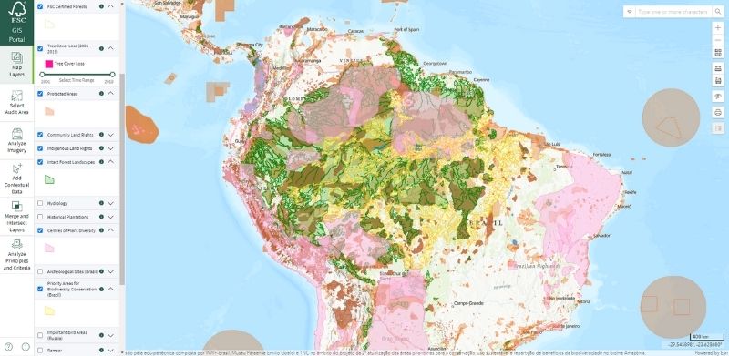
Blue Raster is proud to have developed and supported an audit area tool for the Forest Stewardship Council (FSC). This solution pulls data so that auditors can examine historic and current tree cover before going on site to complete their inspections. Now it’s available with high resolution imagery!

Blue Raster recently integrated high resolution satellite imagery from Planet and Sentinel into the audit area tool. This new imagery, made available by Norway’s International Climate & Forests Initiative, provides 3-meter resolution as compared to the pre-existing 10-meter resolution type used in the tool. This new level of detail in images provides an even clearer picture of forestry practices and realities.

FSC Sustainable Forestry Practices imagery

In addition to the new imagery, the team also updated and reorganized the layer panel to make the maps more user friendly. New tools that measure elevation changes were also added.


Learn more about this project here.


Page 1 of 8