Our Work

Blue Raster helps you tell your story through interactive
mapping technology. Make your message clear, exciting,
and user-friendly for both mobile and web platforms.

Nonprofit/NGO

Blue Raster Pioneering Imagery Management Technology and Delivery Workflows with ArcGIS

Many organizations prioritize the accessibility of imagery and image-derived products for visualization and analysis among both internal and external users. As such, efficient  management and delivery workflows are crucial for these organizations to fully harness the power of spatial data and maximize their product impact. Use cases for aerial images and raster data include land cover classification, urban planning, natural resource management, emergency response and disaster management, precision agriculture and conservation, environmental monitoring and change detection/climate change analysis.

Blue Raster specializes in utilizing the robust capabilities of GIS and cloud services to facilitate the seamless assembly, analysis, management and dissemination of multiresolution imagery, and raster data from different sources and timeframes. Our expertise helps organizations enhance their spatial data management and analysis capabilities.

Employing ArcGIS for Imagery Hosting, Analysis & Management

Empowered by cutting-edge technology, Blue Raster excels in tapping into the full potential of ArcGIS for image hosting, analysis, and delivery workflows across ArcGIS Enterprise, ArcGIS Pro, and ArcGIS Online. With ArcGIS Image Server and ArcGIS Image for ArcGIS Online, we enable organizations to host and conduct dynamic imagery analysis on an unprecedented scale.

The scalability and performance of ArcGIS Image Server redefines the boundaries of what is achievable in geospatial analytics. Additionally, by integrating imagery into the ArcGIS Online platform, organizations can create compelling and informative maps that facilitate a deeper understanding of their spatial data.

Providing On-Demand Imagery Delivery Services

We specialize in providing swift, on-demand collection and smooth delivery of imagery through versatile means including API keys, custom widgets, online user interfaces, and application plugins. Our expertise ensures that you have the necessary tools and support to cater to diverse requirements and preferences.

Whether you need quick access to specific imagery, or a tailored solution embedded within your applications, Blue Raster stands ready to assist, offering a range of flexible and efficient options to meet your unique needs.

Furthermore, we recognize the importance of seamless delivery workflows in ensuring timely access to critical imagery resources. Our solutions are designed to optimize delivery pipelines, minimizing latency and maximizing efficiency. Whether it's delivering imagery to remote field teams or integrating seamlessly with existing systems, we prioritize speed, reliability, and scalability to meet the dynamic needs of our clients.

Our commitment to innovation extends beyond just technology; it's ingrained in our culture. We're constantly exploring new ways to push the boundaries of what's possible, whether it's through advancements in artificial intelligence, cloud computing, or data visualization. By staying at the forefront of technological innovation, we empower our clients to stay ahead of the curve and achieve their objectives with confidence. Our teams of professionals are here to assist you in developing and deploying your delivery workflows.

Pioneering Collaborative Cloud-Based Imagery Management

For over a decade, Blue Raster has been working with clients and partners to deliver large volumes of imagery to support various geospatial workflows. Our cloud specialty has opened new frontiers for collaborative  management. Maximizing the cloud's scalability, organizations can now store, share, and analyze vast amounts of data in real-time. This not only streamlines internal processes but also facilitates effortless collaboration with external stakeholders.

Across the globe, our clients and partners are employing our services to manage and deliver their imagery to support their projects and organizational goals. Here are some examples:

Learn more about our work here

Contact Us

  • This field is for validation purposes and should be left unchanged.


Blue Raster & Smithsonian Promote Internship Program with ArcGIS StoryMaps

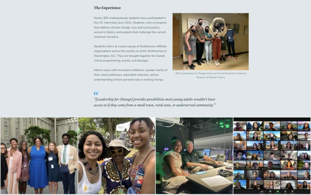
Blue Raster worked to develop an ArcGIS StoryMap to promote the Smithsonian Institution's Leadership for Change Internship Program. The Leadership for Change Internship, helmed by Smithsonian Affiliations, provides paid internship opportunities for students at museums, cultural, and educational organizations that are partners within the Smithsonian Affiliations network. To help showcase the impressive reach of Leadership for Change, Smithsonian Affiliations collaborated with Blue Raster to develop a StoryMap highlighting past internship projects and explaining the program to potential applicants.

What Leads to Successful StoryMap Development?

Blue Raster worked directly with Smithsonian Affiliations to plan and create an ArcGIS StoryMap to meet their goal of promoting the Leadership for Change Internship Program. In planning out the StoryMap content, Smithsonian Affiliations used the StoryMap Accelerator offered by Blue Raster. The StoryMap Accelerator aids development through a series of guided discovery questions that help to outline the narrative and content to be used in the ArcGIS StoryMap.

Highlighting the Internship Experience

Smithsonian Affiliations identified StoryMaps as their preferred platform because it enabled a multimedia showcase of both the opportunities afforded through the Leadership for Change Internship Program and the impressive student internship projects created across the country.

SI Affiliates StoryMap Home Page

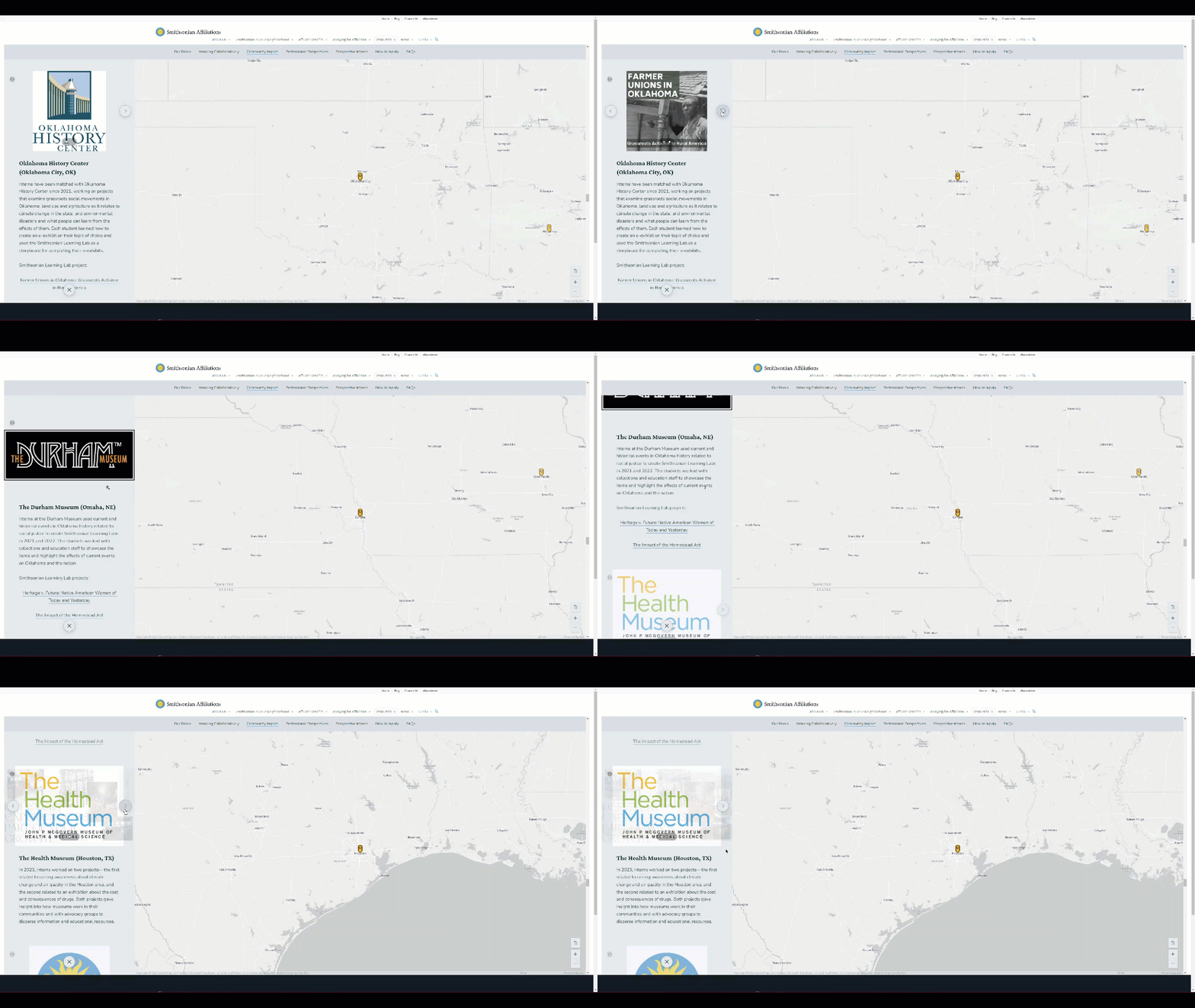
The StoryMap provides a multimedia experience for those looking to learn about Leadership for Change

Smithsonian Affiliations is utilizing the StoryMap as their homepage for the Leadership for Change Internship Program this year. Blue Raster worked within the Smithsonian’s timeline to allow for a launch date right at the beginning of 2024.  The deadline to apply for the Leadership for Change internship program is February 26th, 2024. We encourage everyone to share this great opportunity with young people that may be interested in applying.

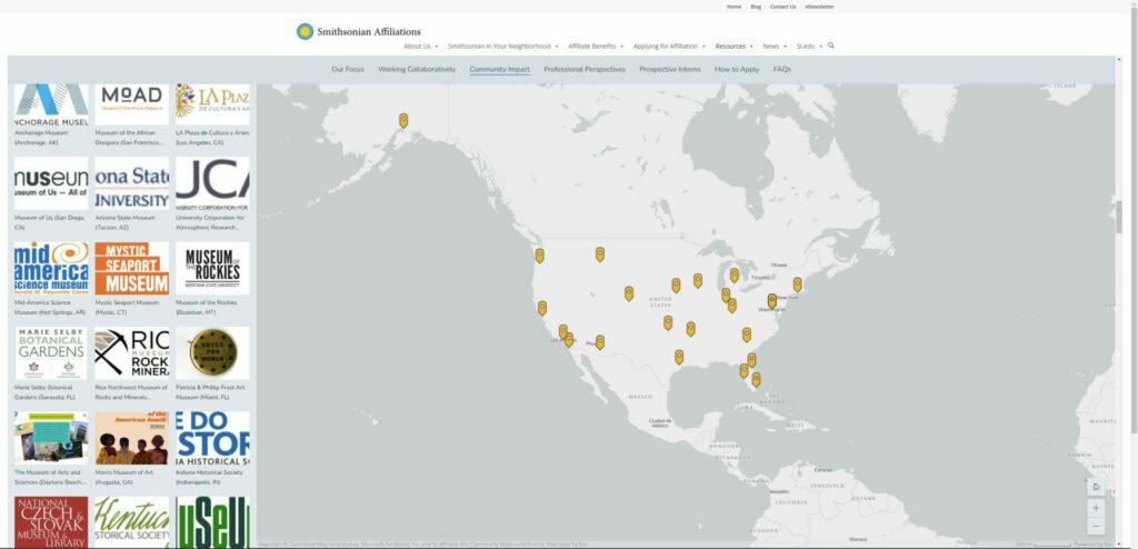
Map Showing national impact of intern projects

The map portion of the StoryMap highlights the nation-wide community impacts of past internship projects

Enrich your Projects with ArcGIS StoryMaps

Blue Raster is here to discuss your project and explore the possibilities of ArcGIS Story Maps. Our talented team of designers and GIS analysts will work closely with you to understand your goals and vision. Blue Raster can turn your ideas into immersive and engaging narratives that leave a lasting impact. Contact Blue Raster now to embark on a journey of storytelling, innovation, and project enrichment.

SI Affiliations StoryMap Overview

Overview of ArcGIS Story Map

Are you ready to tell your story?

Contact Us

  • This field is for validation purposes and should be left unchanged.

Templeton Roots & Shoots Prizes: Honoring International Changemakers Who Are Making A Difference

Blue Raster is proud to announce another project from our long running collaboration with The Jane Goodall Institute.

Among Jane Goodall's many vital programs is Roots & Shoots, with the mission to empower young people to affect positive change in their communities.

In 2023, JGI collaborated with the John Templeton Foundation to award the Templeton Roots & Shoots Prizes.

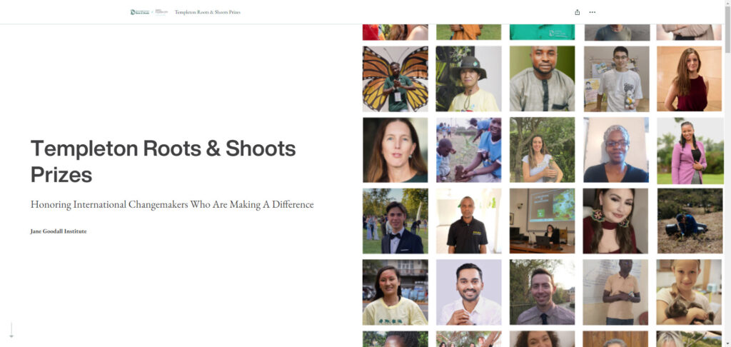
Jane Goodall Templeton StoryMap

From the JGI website: "The Templeton Roots & Shoots Prizes are an extension of the partnership between JGI and the John Templeton Foundation to elevate the extraordinary efforts of visionary youth leaders and their adult mentors worldwide.  Awardees were selected based on their exceptional work with Roots & Shoots at the intersection of science, compassion, and community – specifically those who exemplify curiosity and wonder and the pursuit of knowledge, as well as the expression of compassion towards people, other animals and the environment we share."

When Erin Griffin, Director of Partnerships, Jane Goodall Institute-USA sought a novel way to showcase the 30 winners of the inaugural Templeton Roots & Shoots Prizes she turned to trusted partner Blue Raster and the concept of an ArcGIS StoryMap.

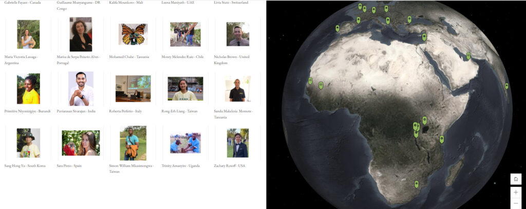
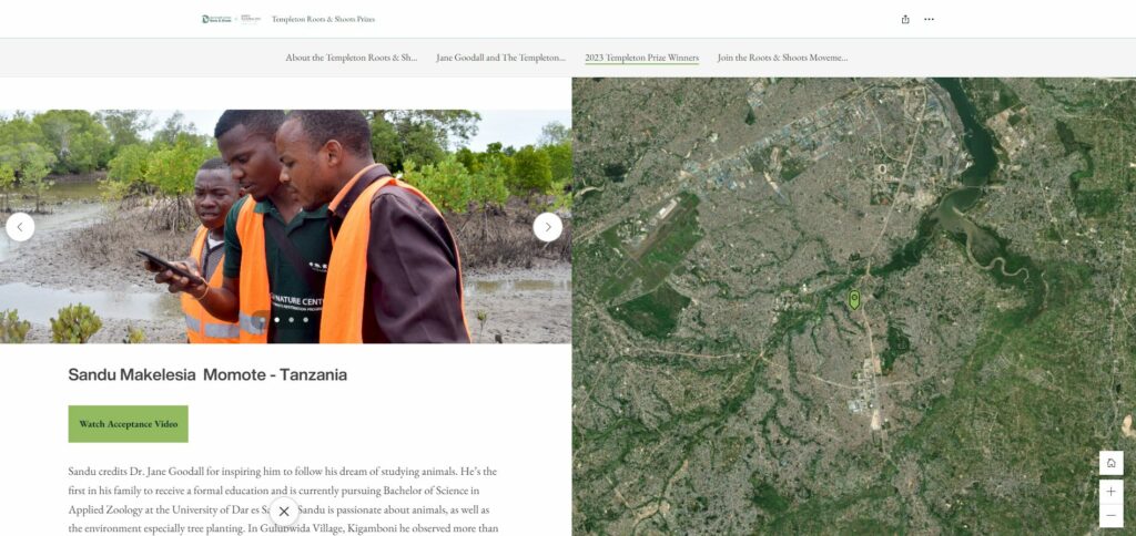
The StoryMap showcases the 2023 winners and features an interactive map, videos and a brief write up of each winner and their vital contributions.

StoryMap screenshot

Blue Raster built several StoryMaps for The Jane Goodall Institute. The platform is ideal for visual story telling, with or without a map based visualization.

Check out the Templeton Roots & Shoots Prizes StoryMap, honoring international changemakers who are making a difference today!

Templeton StoryMap

Ready to tell your story?

Contact Us

  • This field is for validation purposes and should be left unchanged.

Above the Waters: A Cinematic Journey Through the Delaware River Watershed

The Delaware River holds a rich tapestry of history, playing a pivotal role in the development of the United States and serving as a witness to centuries of human activity. Flowing for approximately 330 miles through the eastern United States, the river originates in the Catskill Mountains of New York and eventually empties into the Delaware Bay. Its watershed encompasses parts of New York, New Jersey, Pennsylvania, and Delaware, making it a vital waterway that has shaped the region's cultural, economic, and environmental landscape.

It serves as a source of drinking water, supports diverse ecosystems, and offers recreational opportunities. Efforts to balance conservation and development persist, as communities work together to ensure the sustainable use and preservation of this historic and ecologically significant waterway. Today, the Delaware River continues to play a crucial role in the lives of millions of people. The Delaware River stands as a symbol of the intertwined relationship between human societies and the natural environment, showcasing the ongoing importance of responsible stewardship for future generations.

Telling the Story of the Delaware River Watershed

Blue Raster partnered with Delaware Currents to create and deliver an educational video about the Delaware river watershed. With aerial footage provided by Light Hawk and contributions from Delaware River Basin Commission (DRBC) and Partnership for the Delaware Estuary (PDE), viewers can embark on an immersive journey along the Delaware River learning about its history, challenges and significance.

Embarking on a flight along the Delaware River unveils a captivating journey through time, weaving together the threads of history, culture, and environmental significance that have shaped this iconic waterway and its expansive watershed. This aerial expedition provides a unique perspective, allowing us to appreciate the interconnectedness of the region's past, present, and future.


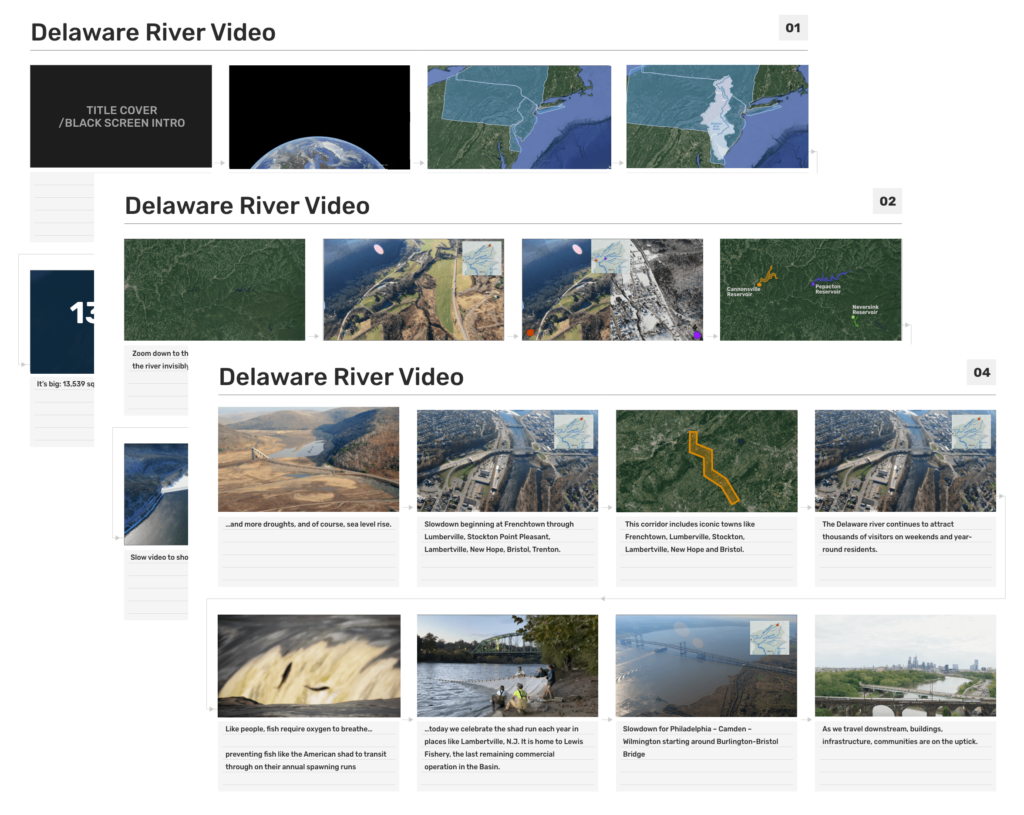
Delaware River Storyboard

As we approach the 20th century, the flight takes us over urban centers and industrial landscapes, bearing witness to the environmental challenges that emerged. Efforts to balance industrial progress with environmental preservation became increasingly critical, leading to the establishment of regulatory bodies like the Delaware River Basin Commission. This commitment to conservation aimed to protect the river's waters and ecosystems for future generations.

The journey concludes as we survey the modern landscape shaped by environmental stewardship and community engagement. The Delaware River stands as a testament to the resilience of ecosystems, the importance of clean water, and the ongoing efforts to balance human needs with environmental sustainability. From the headwaters to the estuary, the flight along the Delaware River highlights not just a waterway but a living, breathing testament to the intertwined history, culture, and ecology of the region—a journey through our history, our watershed.

The Impact of Partnerships in Storytelling

The creation of the video  involved a collaborative effort, bringing together various organizations, contributors, and media partners to produce a visually stunning and informative exploration of the Delaware River. Brought to you by Delaware Currents, the video's production was made possible through the support of key entities and contributors. The Blue Raster team was responsible for editing and production of the video, incorporating GIS element to provide a more spatial context and location-based visualizations. Of particular note, the DRBC played a pivotal role in providing insights into the river's management, regulatory efforts, and environmental conservation while the Partnership for the Delaware Estuary added valuable insights into the ecological importance of the river's estuarine region and its role in sustaining diverse ecosystems. Media partners played a crucial role in amplifying the project's reach, ensuring that the video's content was well researched and reached the necessary audiences through various platforms.

Ready to tell your story?

Contact Us

  • This field is for validation purposes and should be left unchanged.

South Park Arboretum’s Plant Finder uses ArcGIS Experience Builder to Showcase Restoration Efforts

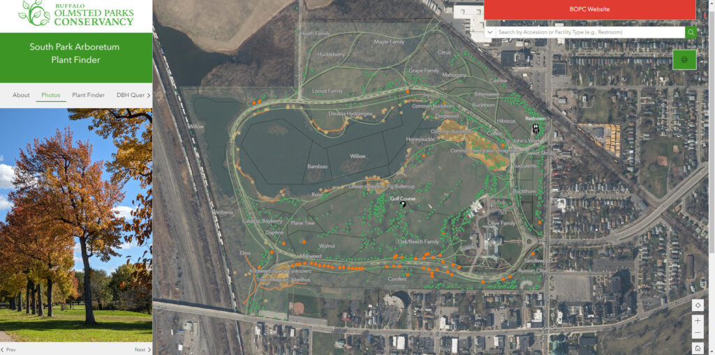
Blue Raster partnered with Buffalo Olmsted Parks Conservancy (BOPC) to develop the South Park Arboretum Plant Finder application using ArcGIS Experience Builder and assist in the data management of South Park Arboretum’s “outdoor museum of trees”. With the launch of their new website on November 10th, visitors to the arboretum will have a new tool in hand that allows them to explore individual plant records, search information about featured plantings, get restoration project updates, and learn how South Park Arboretum staff are mitigating and managing invasive species on the property.

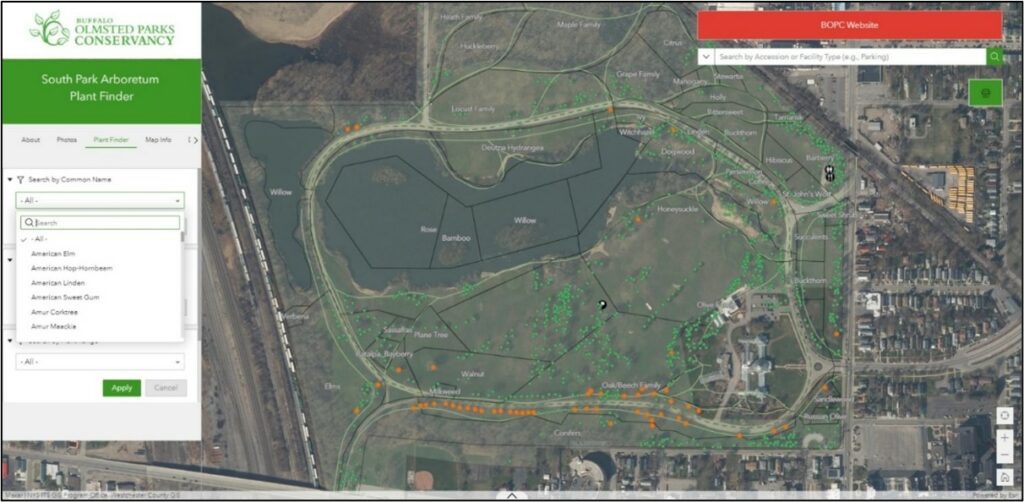
Plant Finder Application Developed with ArcGIS Experience Builder

Plant Finder Application Developed with ArcGIS Experience Builder

Historic Restoration of South Park Arboretum

Located in Buffalo, New York and unique to the historic Olmsted park and parkway system is South Park Arboretum, an arboretum that was on par with the most notable arboreta of the late 19th century and early 20th century. The multi-year, eleven phase restoration of the South Park Arboretum, consisting of 155 acres of historic and culturally significant "Olmstedian" character-defining features, including approximately 400 “Olmsted Original” or heritage trees, is an exceptional feat, requiring significant oversight and planning. The vision behind the restoration is to capture and integrate Olmsted’s original design into the current park by selective plant evaluation for their contribution to the collection including plant removal, cultivation, and care of “Olmsted Original” trees that support the original taxonomical organization that the Olmsted design established in 1895.

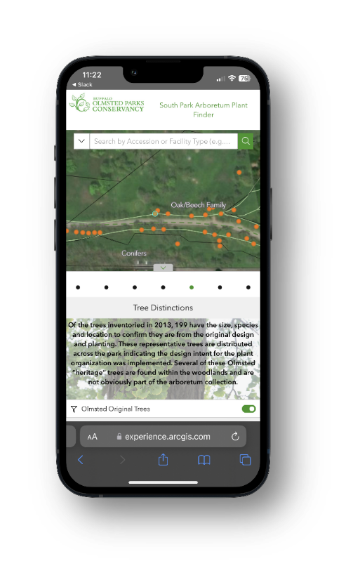
ArcGIS Experience Builder Mobile View

ArcGIS Experience Builder Mobile View of Plant Finder Application

Developing Plant Finder with ArcGIS Experience Builder

Blue Raster established an ArcGIS Online environment for BOPC by leveraging their status as a non-profit for reduced software costs. We then assisted with preparing and publishing data and identifying additional datasets of interest. Blue Raster successfully ingested plant records data into our plant synchronization workflow – which automates updates from BG-BASE, the organization's botanical repository, into GIS. This workflow provides staff with the ability to make data modifications in the field, while pushing the data back to the system of record seamlessly.

After finishing the backend data workflows, Blue Raster designed and developed an ArcGIS Experience Builder application for both internal and public use. The application contains filters, queries, and navigational tabs for users to identify trees of interest, facilities information, featured photos and plantings, reference data such as Olmsted’s original 1895 Planting Plan, and a survey for visitor feedback. As the application was developed with a mobile-friendly design in mind, users can easily use the tool while on the grounds to navigate and find relevant information.

When working to finalize the Plant Finder mapping application to coincide with the launch of the new website, South Park Arboretum’s Director and Curator, Margaret Lapp, had this to say about the efforts to make their data more accessible for staff and the public by utilizing GIS

“Partnering with Blue Raster and BG-BASE has proven invaluable to the Arboretum’s overall restoration and awareness-building efforts. GIS enables South Park Arboretum to integrate collections documentation with geographically referenced information supporting tree care, its coordination and curation alongside public enjoyment and discovery. The launch of the Plant Finder App. is a testament to Frederick Law Olmsted’s democratic and inclusive principles and transcends time in upholding Olmsted’s vision—to create an Arboretum where visitors could observe and learn about plants. BOPC is absolutely delighted to share our plant collection with the community near and far, fostering a spirit of curiosity for the natural world.”

- Margaret Lapp, Director and Curator, South Park Arboretum

Plant Finder Application Developed with ArcGIS Experience Builder

Plant Finder Application Developed with ArcGIS Experience Builder

Learn More About Blue Raster's Work with Public Gardens and Arboreta 

Blue Raster is an Esri Gold Business Partner and Nonprofit Specialty holder. Blue Raster is excited to support Public Gardens clients and bring awareness to some of the most beautiful and historic public spaces. Learn more about Blue Raster’s long history working with Public Gardens on innovative GIS solutions for staff and the public.

Contact Us Today!

  • This field is for validation purposes and should be left unchanged.

Page 1 of 32