Public Safety

WHO Malaria Threats Map: Tracking challenges of malaria control to 2030

Blue Raster is proud to announce the debut of the Malaria Threats Map application, a collaboration with the World Health Organization (WHO) aimed at tracking biological challenges to malaria control and elimination.

Recent trends are emerging that necessitate a need for authorities to adapt plans for control and elimination of Malaria and counter the growing threat.

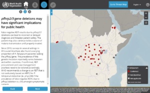
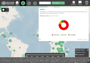
The application is the sole source for linked spatial and analytical data about these three trends:

  • Vector Insecticide Resistance -resistance of malaria mosquitoes to insecticides
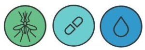
  • Parasite Gene Deletions-Gene deletions among some malaria parasites cause false negative diagnostic test results
  • Parasite Drug Resistance– Resistance of malaria parasites to artemisinin, core compound of the best available antimalarial medicines – threatens antimalarial drug efficacy

The application offers a story-map like feeling by introducing data through curated narratives and is available in English, French and Spanish.

Using technologies such as ArcGIS for Server, ArcGIS API for JavaScript, React, Redux, and HTML5 the application displays detailed information to users and allows them to filter for thousands of historic outcomes.


Phase I of the application was completed in 2017 with plans for a Phase II in 2018.


 Read more about the application on the WHO site.


A New Chapter on Tsunami Design

New design provisions for tsunami loads and effects have been developed by the ASCE 7 Tsunami Loads and Effects Subcommittee (TLESC), and are included in the just-released 2016 edition of the internationally recognized loading standard ASCE 7, Minimum Design Loads and Associated Criteria for Buildings and Other Structures (ASCE/SEI 7-16). This resource and accompanying data was developed over a 34-month period by a subcommittee of almost 30 members, along with the contributions and review of numerous other state, national, and international stakeholders. To provide the authoritative distribution of this tsunami design information, Blue Raster and the Structural Engineering Institute of ASCE have created the ASCE Tsunami Design Geodatabase application.

Offshore Tsunami Amplitude Analysis

The ASCE Tsunami Design Geodatabase application provides insight into the first national, consensus-based standard for tsunami resilience for use in the states of Alaska, Washington, Oregon, California, and Hawaii. Structural engineers are already being asked to incorporate tsunami-resilient designs in various critical building and facility structures in the five western states, The profession and the affected communities now have a comprehensive consensus on loading and design standards for buildings and other structures.

Transect of Elevation

The new tsunami design zone maps define the coastal zones where structures of specified risk would be designed for tsunami resistance. Easy access to this data through the ASCE Tsunami Design Geodatabase application is imperative for the resiliency of our coastal infrastructure.

New Release: APTA Industry Footprint

Following the successful launch of American Public Transportation Association’s (APTA) Industry Footprint, Blue Raster has delivered Version 2. The web application provides users with a comprehensive understanding of the role of public transportation in their communities and throughout the United States. Given that public transportation provides essential mobility to people throughout the country, reduces congestion in crowded cities, and improves air quality, APTA hopes to encourage people to opt for it more often and fight for continued support and funding from state and federal legislators.

The latest version of Industry Footprint includes helpful new features:

  • Addition of bus and rail manufacturers to the map
  • Addition of state legislative upper and lower chambers to the map
  • Updated user interface

Now everyone can view APTA’s Transportation Industry Footprint to get key facts and statistics about where public transportation is available and how it’s being used in their state legislative and congressional district boundaries.

Blue Raster built upon the first version of the tool by integrating the Sunlight Foundation’s Open States API for up-to-date details on state legislators and state legislative districts. The transit information is obtained from TransitFeeds, which offers an extensive archive of standardized transit lines and schedules.

Enhancing Public Access to GIS

The National Alliance for Public Safety GIS Foundation (NAPSG), is committed to enhancing public safety one community at a time and building a more resilient nation across all levels of government. With the help of Blue Raster, NAPSG enhanced their website in two ways:

  • Modernize the resource library turning it into an organized, user-friendly data outlet
  • Created a symbol library establishing a common language for incident information

resourcepage

symbols

The Resources Page is a publicly accessible data platform, allowing communities and local entities access to key resources that aid in decision making. The Resources page is built with Wordpress and features newly organized categories and search functionality, Researchers can now pinpoint what is needed and where to find it quickly rather than spending time scrolling through information.

Built with React JS, Flux and Python, the Symbol Library provides a set of standardized incident symbols that can be used on maps and in GIS applications. Framework and guidelines are included to ensure that all of the downloadable data is used properly and consistently. Complete with its own Library Tool, symbols can be downloaded on an individual level or by topic.


Blue Raster understood our community’s needs and requirements out of the gate. This made designing the solution for our Symbol Library Tool and reorganization of resources on our website a much more streamlined and efficient process. Again the Blue Raster Team exceeded our expectations.
-Rebecca Harned, Senior Program Manager, National Alliance for Public Safety GIS Foundation


NAPSG Redesigns A Roadmap for Public Safety GIS

The NAPSG (National Alliance for Public Safety GIS Foundation), a not-for-profit organization specializing in preparedness, mitigation, response, and recovery in the sphere of public safety, recently launched its redesigned website with the Capability and Readiness Assessment Tool (CARAT). Built in partnership with Blue Raster, Interra Group, and a number of other Geospatial Management Organizations, CARAT provides public safety practitioners with information on building, directing, or enhancing a GIS program.

firefighter

The tool uses the simple continuum – Crawl, Walk, or Run, to help decision makers identify their current GIS capability and conceptualize potential areas where GIS could improve operations. Topics are sorted into four categories: Planning, Preparedness, Response, and Recovery, and case studies are offered to help users implement similar functionality into their work.

NAPSG Capability and Readiness Assessment Tool built by Blue Raster

CARAT’s design makes it possible for anyone, from basic capability to advanced problem solving, to connect with this dynamic knowledge base. The repository of people, tools and experience offers public safety practitioners a comprehensive guide for integrating GIS into their daily operations. To learn more, visit http://napsgfoundation.org/carat/.


Page 2 of 2