Our Work

Blue Raster helps you tell your story through interactive
mapping technology. Make your message clear, exciting,
and user-friendly for both mobile and web platforms.

Uncategorized

Conducting Research and Data Analysis for The Nature Conservancy’s Coastal Restoration Opportunities Project

The Nature Conservancy (TNC) is a global environmental nonprofit that works to conserve the vital bodies of water and land on our planet, and it is also a long-term partner of Blue Raster. From 2021 until 2023, Blue Raster once again collaborated with TNC to help the organization with a project that aims to restore critical coastal habitats.

Determining Goals for TNC’s Coastal Restoration Opportunities Project

TNC required Blue Raster’s support in meeting its main goals for the Coastal Restoration Opportunities project, which included:

  • Delineating, mapping, and quantifying coastal restoration opportunities for five coastal habitats in the United States
  • Establishing natural historical and current habitat occurrences through research, subject matter expert surveys, and literature reviews
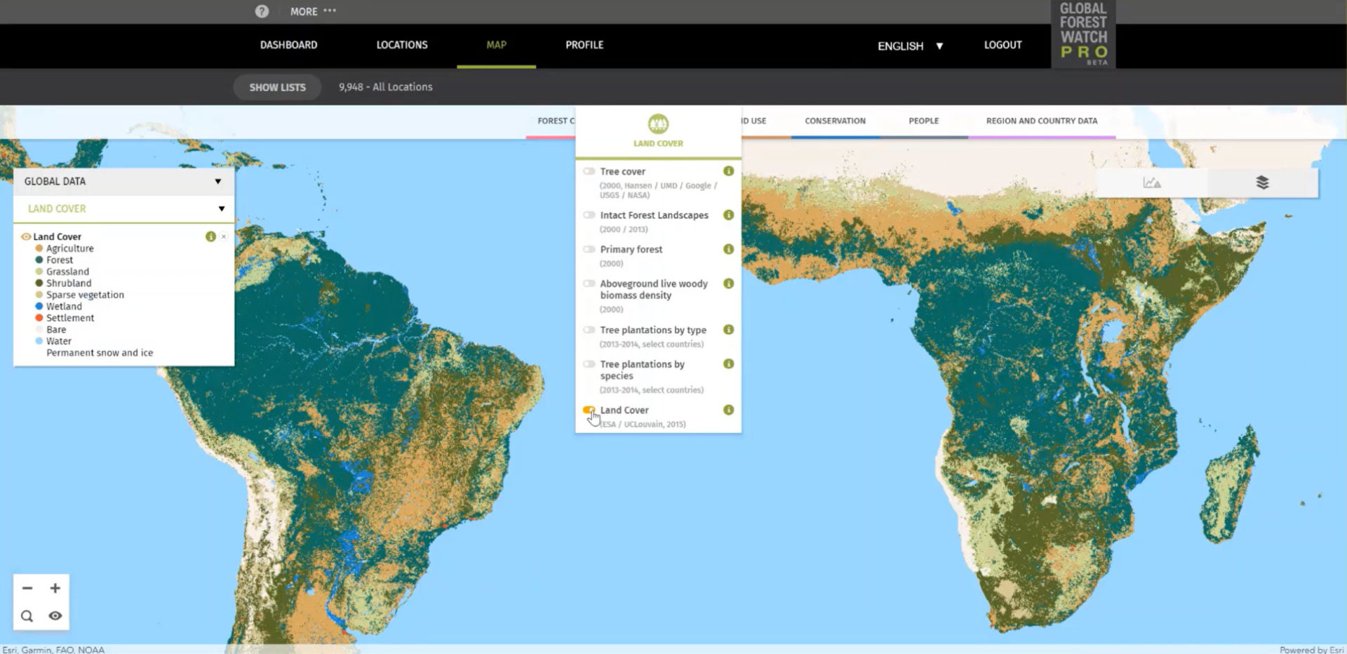
  • Creating interactive restoration opportunities maps

A Mission Rooted in History

Unlike some of the past projects for TNC, this one did not involve an application build-out. Instead, Blue Raster’s Abigail Krump and Jen Kern worked closely with TNC staffer, Bryan DeAngelis, and ocean resiliency expert, Annick Cros, to find, analyze, document, and map valuable datasets for the project. The five main datasets, which are habitats targeted for restoration opportunities, include:

  1. Oyster beds
  2. Salt marshes
  3. Mangroves
  4. Seagrass beds
  5. Kelp

In order to establish a historical baseline for the Coastal Restoration Opportunities project, Krump and Kern had to look at existing datasets from the government, satellite imagery, old scientific papers, and more. Inside the scientific papers, Krump and Kern often found hand-sketched maps or survey notes, which they then transformed into interactive restoration opportunities maps.

Coastal Restoration Opportunities

Impacting the Future of Restoration

The historic data collected by both teams has been published in various scientific journals and is available for scientists and coastal habitat experts to use for their own purposes, but the main goal is for it to be used to support and build cases for funding coastal restoration projects.

And the influence of TNC’s Coastal Restoration Opportunities project hasn’t halted since Blue Raster completed the research, data analysis, and map creation to produce the historical benchmarking resource the nonprofit requested. In fact, the datasets are already being used to support the pending legislation of California Assembly Bill 1407, the Ocean Life Recovery Act. If passed, Assembly Bill 1407 would protect California’s ocean ecosystems, including kelp, eelgrass, and native oysters, by launching essential restoration projects with the necessary backing from the state.

Could your organization’s data help change the world? Find out with research and data analysis support from Blue Raster.

Haverford College Campus Placefinder

Like most colleges, Haverford College has a dynamic campus life that requires significant management and planning to run smoothly. But recently, Haverford College decided to make this planning easier on themselves by using the power of GIS to their advantage. They were looking for a better solution for their campus planning, so they partnered with Blue Raster to create the Campus Placefinder.

The Campus Placefinder is an application built for Haverford’s facilities management team that provides an easy-to-use interface to access information about facilities on campus. The application allows users to interact with floor plans, and see details such as capacity and occupancy for every room on campus. The app also creates graphs that detail the area of rooms by building, department, or division. With drawing and printing capabilities, this application serves as a way for users to note changes to campus buildings as soon as they’re needed, and easily create a printout to distribute.

Haverford

Blue Raster built this application to be user-friendly by using custom filters and a search bar so users can quickly find the space they need. Whether the user is looking for a certain building, department on campus, or primary occupant, Campus Placefinder will find the answer, and immediately take the user to the location on the map. With an admin login, a user can edit room information, so the facilities management department can keep all room information up to date. Because the data is hosted through ArcGIS Online, the changes are then immediately available to all other users.

Through this application Blue Raster helped Haverford College improve their facilities data process which will serve the facilities management department as well as Haverford College’s faculty, staff, and students.

Contact Blue Raster today to learn how you can create GIS solutions to meet your needs!

Improving Deforestation Risk Management in Commodity Supply Chain

Blue Raster developed Global Forest Watch Pro, a decision support tool that empowers companies to monitor their supply chains for responsible environmental practices. Companies can upload all of their of sourcing areas, farms, and supply sheds for analysis and view interactive maps and diagnostics displaying occurrences of deforestation, alerts for forest fires, land cover types. The site now serves nearly 1,000 users across approximately 350 organizational accounts. Current users are spread across every continent in the world.

GFW Pro map

To support the growing use, Blue Raster recently implemented several updates. The analysis back-end is modernized to make it more scalable and provides more power for processing data faster. The team also moved to a Spark engine and incorporated an AWS Step workflow to allow for higher data processing capacity and improved functionality for the tool.

WHO Malaria Threats Map: Tracking challenges of malaria control to 2030

Blue Raster is proud to announce the debut of the Malaria Threats Map application, a collaboration with the World Health Organization (WHO) aimed at tracking biological challenges to malaria control and elimination.

Recent trends are emerging that necessitate a need for authorities to adapt plans for control and elimination of Malaria and counter the growing threat.

The application is the sole source for linked spatial and analytical data about these three trends:

  • Vector Insecticide Resistance -resistance of malaria mosquitoes to insecticides
  • Parasite Gene Deletions-Gene deletions among some malaria parasites cause false negative diagnostic test results
  • Parasite Drug Resistance– Resistance of malaria parasites to artemisinin, core compound of the best available antimalarial medicines – threatens antimalarial drug efficacy

The application offers a story-map like feeling by introducing data through curated narratives and is available in English, French and Spanish.

Using technologies such as ArcGIS for Server, ArcGIS API for JavaScript, React, Redux, and HTML5 the application displays detailed information to users and allows them to filter for thousands of historic outcomes.


Phase I of the application was completed in 2017 with plans for a Phase II in 2018.


 Read more about the application on the WHO site.


Historic Zoning in DC

Blue Raster worked with the DC Office of Zoning (DCOZ) to compile scanned versions of the 1958 zoning data as it evolved over approximately 60 years to present day. The data was georeferenced and converted to digital services and then displayed through an interactive application that allows users to choose a year of interest and see which case records happened on or before that year. By investigating the evolution of the zoning information for a property, insight can be gained into the when and why a change occurred.

By using a responsive design, the information is now available across a number of devices and browsers. Be sure to explore the history of your zone today!

DCOZ Historic Zoning Viewer


Page 1 of 2