Smithsonian Institute

Phase II of eMammal Project ‘Captures’ Attention

Blue Raster is pleased to announce the completion of the second phase of eMammal, a collaboration between researchers at the Smithsonian Institution and North Carolina Museum of Natural Sciences.   The objective of eMammal is to document the effect of recreational use of conservation areas on animal populations.  To help in the effort, citizen scientists have joined forces with the researchers to deploy camera traps near and off trails of popular parks like Shenandoah National Park and Catoctin Mountain Park. They then retrieve and process the images collected using tools created by Blue Raster in the initial phase of the project.

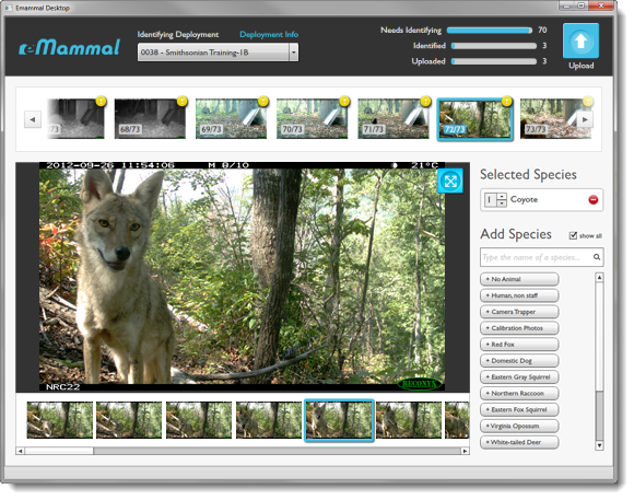
The first season was a huge success with over 1 million photos collected, the species identified, and the images archived and awaiting review by the researchers. With the prospect of another 3 million photos on the way with the coming second season, Smithsonian asked Blue Raster to build an Expert Review Tool that would allow them to review the images and subsequent metadata from the first season.

Using Amazon EC2 Servers and S3 as the system infrastructure, the Expert Review Tool provides scientists with the means to see the collected photos and confirm or change the species identification and individual counts made by the volunteers. The tool allows researchers the ability to monitor the progression of their review process via a dashboard and ‘favorite’ images that can then be posted to the eMammal Facebook page and in return shared with the volunteers and others interested in the project. The tool also includes an interactive map, built on Esri ArcGIS API for JavaScript, which displays the camera trap latitude and longitude points that the volunteers collected using GPS devices.

By verifying the camera trap deployment images and data as well as locations, scientists for eMammal hope to document and map species ranges and population statistics.   With the success of the first Mid-Atlantic season, the collective team at the Smithsonian Institution, North Carolina Museum of Natural Sciences and Blue Raster looks to scale eMammal to be used in other regions across the US and worldwide. The images and data collected will help answer questions about mammal distribution and abundance, aiding the efforts of wildlife conservation.

eMammal – A Citizen Scientist Camera Trapping Project

eMammal is a project where citizen scientists work in collaboration with researchers at the Smithsonian Institution and North Carolina Museum of Natural Sciences to document mammals throughout the mid-Atlantic region, and soon, the entire country. Citizen volunteers place “camera traps”, infrared activated cameras, across the landscape in parks and other natural areas to collect photos of mammals. These photos help researchers answer questions about mammal distribution and abundance and use this information for conservation.

The first phase of this project was the Smithsonian Wild prototype funded through a grant which has evolved into eMammal.  To help manage the new camera trap data, Blue Raster and partner Orion Creative Group built a camera trap management and identification system.  Deployed on Drupal 7, the system manages volunteer and camera trap data for the research team. An Adobe AIR Desktop application allows citizen scientists to identify ‘captured’ animal photos and upload to the image repository in Amazon S3. Then the camera trap photos and metadata are collected by eMammal scientists and analyzed.

eMammal Species ID Tool

“eMammal is at the cutting edge intersection of the new technologies surrounding cloud computing and “big data” and the time honored tradition of citizens volunteering to help conservation efforts,” said Smithsonian Conservation Biology Institute Conservation Biologist, Tavis Forrester, Ph.D.

The next phase of eMammal will be the creation of a robust website where photos will be displayed along with project site information. Crowd sourcing for species identification will also be explored. Keep an eye out in 2013 for these great additions to the eMammal project. Visit http://facebook.com/eMammal to see a sampling of the best photos and keep up to date on our progress.

Smithsonian WILD

Candid Cameras Show Rare Glimpses of Wildlife

As part of a Smithsonian Web 2.0 grant, Blue Raster has developed Smithsonian Wild, an interactive web mapping application for the Smithsonian National Museum of Natural History using ESRI ArcGIS.com, ArcGIS Server Flex API, and Flickr.

Smithsonian WILD

This web site offers the public a unique opportunity to observe over 250 different species in their natural habitats throughout the world.  Motion-activated ‘camera traps’ placed in various regions across the globe capture over 201,000 still images and ‘near-video’ sequences of animals as they pass.  Robert Costello, a national outreach program manager for the Smithsonian National Museum of Natural History, hopes visitors to the site “feel a sense of anticipation and excitement, like the researchers, as they explore photographs of wildlife taken in the absence of human beings and often at very short distances.”

Smithsonian WildSmithsonian Wild also offers detailed descriptions of the diverse animals and regions as well as a world map so the user is always aware where the animal being observed is located in China, Kenya, Malaysia, Panama, Peru, Thailand, or the United States.  Customized searches allow the user to choose the path of this entertaining and educational experience via species, group, or region.  Please visit Smithsonian Wild at http://siwild.si.edu/ today to view these amazing pictures and get your own rare glimpse into the animal world.  To learn more details please go to the Natural History Museum’s blog post.
Smithsonian Wild

Smithsonian – North American Mammals

Smithsonian National Museum of Natural History has asked Blue Raster to recreate its interactive searching tool for North American Mammals.  Migrating from the legacy ArcIMS application to ESRI ArcGIS Server and Flex API with a custom-based map, this web site has been designed to serve as a comprehensive resource for students, teachers, and the general public and will make accessible the Museum’s unparalleled natural history collections, scientific research, permanent and special exhibits, and libraries.  With detailed descriptions, images, and distribution ranges for more than 400 mammals native to the North American continent, this new application allows users to examine the distribution of mammals over the continent through complex and customized searches of animals, locations, and conservation statuses.  The map provides a variety of filters to refine a user’s search, including topography. Users can also create a Field Guide from their search to take into the outdoors. For more information regarding the Smithsonian National Museum of Natural History launch-please visit North American Mammals.
Smithsonian North American Mammals


Page 2 of 2