Our Work

Blue Raster helps you tell your story through interactive
mapping technology. Make your message clear, exciting,
and user-friendly for both mobile and web platforms.

The Earth Genome

Answering the Call for More Sustainable Groundwater Management with GRAT

From replenishing and regulating the human body to nurturing and fueling our environments, water is a valuable commodity that we cannot live without. In areas where rainfall can be unreliable, or drought often occurs—such as the western United States—alternative methods must be used to supply water to impacted communities and their agricultural regions. With the frequency of droughts in California, groundwater pumping is a widely-used tactic to combat the scarcity of natural water placement, but in time the groundwater used must be recharged to avoid an imbalance.

That’s why the Groundwater Recharge Assessment Tool (GRAT) was developed in partnership with The Earth Genome and Sustainable Conservation. It’s a valuable decision support tool that enables Groundwater Sustainability Agencies (GSAs) to identify and prioritize potential groundwater replenishment options to achieve sustainable groundwater supplies. This technical tool was originally created for the Madera and Tulare Irrigation Districts and the Rosedale-Rio Bravo Water Storage District to help model recharge scenarios across different fields using various recharge types. The goal was to help these districts understand where water is, how it can get to crop fields, and how it can be used to prepare for droughts—all while being more sustainable.

Building Out the Application

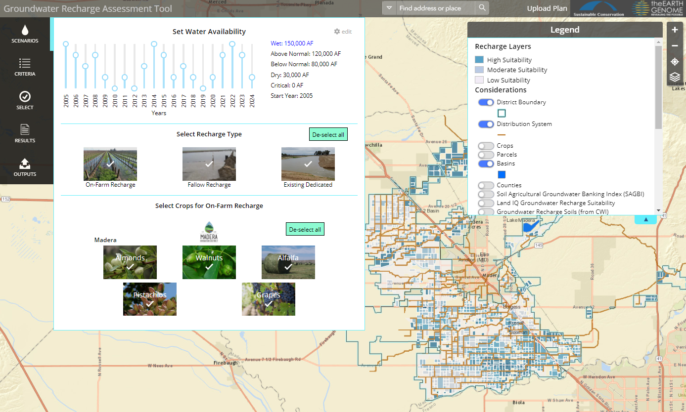
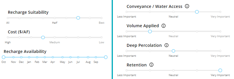
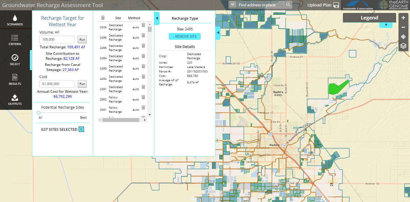
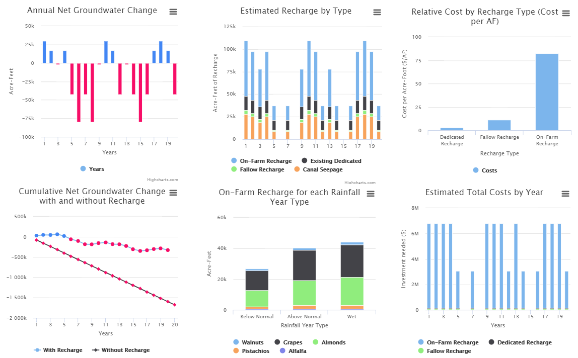
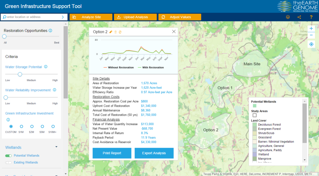
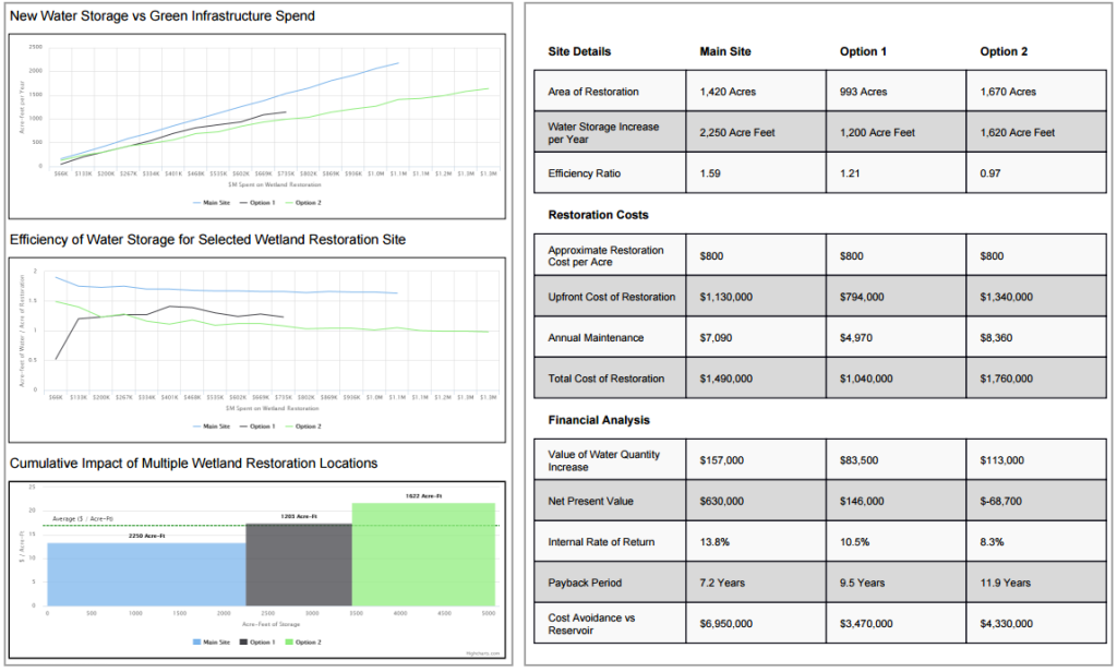
With data from the districts and complex, analytical logic provided by The Earth Genome and Sustainable Conservation, Blue Raster was able to help design and develop GRAT using ArcGIS Enterprise and the ArcGIS API for JavaScript. The application allows users from select California water districts to adjust water availability scenarios, recharge types, and specific crops used in the analysis. The application details site locations, fields’ recharge suitability, and impacted crop types, and visually shows on the map sites where water is placed. A series of charts and graphs provide information on groundwater change, recharge by crop, unused water available for recharge, and costs associated with the proposed recharge.

Blue Raster was responsible for preparing the data for use in the application and converting the analysis logic to an interactive mapping application. Our team formatted the datasets provided by the districts to create the crop layer, apply indices that rank and prioritize sites as well as determine suitability, and allow for different scenarios to be run against the GRAT logic.

Looking Towards the Future of GRAT

With GRAT being utilized by other GSAs in California, various water districts have expressed the need for more map-centric, data-visualized applications. In 2022, we helped launch the Turlock Subbasin GRAT for the East and West Turlock Subbasins. Similar in purpose and design to the original GRAT tool, the Turlock Subbasin GRAT also features enhancements related to proposed projects that could impact how water reaches fields and is placed and introduces new recharge types.

With the concentrated efforts of The Earth Genome and Sustainable Conservation, and using the GRAT platform, additional water districts throughout Central California can implement more effective and environmental solutions for groundwater recharge. The Blue Raster team looks forward to partnering with both organizations to help ensure groundwater balance and effective management now and into the future.

Groundwater Recharge Assessment Tool (GRAT)

Interested in Learning More About GRAT?

Contact us to learn more about this application or to discuss how interactive mapping technology can enhance your data.

Solving the Water Balance Equation for California

Drought has been a significant concern throughout much of the western U.S., threatening the livelihood of farmers and communities across several states. When years of drought stretch on, groundwater pumping often becomes the most viable option for the agriculture sector, leading to a negative water-balance and increasingly sparse water availability. Local water authorities are scrambling to recharge the groundwater supplies for their districts’ agricultural needs.

Fortunately, a new tool for their arsenal is now available – the Groundwater Recharge Assessment Tool (GRAT), developed in partnership with The Earth Genome and Sustainable Conservation. Through a prioritized use of dedicated recharge basins, fallow field recharge, and on-farm recharge sites, it may be possible to balance the water budget and reverse the damage caused by years of over-pumping. On-farm recharge is a relatively new approach and requires an understanding of what crops are being grown, and how flood-year waters could be applied during select weeks of the year when high-flow water is available. Currently much of that water runs off the landscape and eventually into the ocean, but on-farm recharge may provide the key to capturing that water by recharging underlying aquifers.

To calculate the best use of on-farm recharge and the impact on the water budget, GRAT allows irrigation districts to run an unlimited number of wet-year scenarios, ranking of field types based on soil and crop characteristics, and detailed cost calculations.

Setting detailed criteria requirements helps to optimize the selection of sites based on an irrigation district’s individual needs. Weighted indexes are calculated dynamically using a number of geophysical variables linked to each criteria.

GRAT allows the automated selection of sites up to a target recharge volume or cost ceiling, and then the manual removal or selection of additional sites based on local expert knowledge.

Advanced, dynamic charting gives real-time updates of groundwater balance and estimated costs based on selected sites. Once the balance has been reached, the option to save the plan can be used to share results with decision makers throughout the district.

GRAT was co-created in collaboration with Madera Irrigation District and Tulare Irrigation District.  It is also now being rolled out to other interested Groundwater Sustainability Agencies (GSAs) in California, to support their Sustainable Groundwater Management Act (SGMA) reporting requirements.


Turning Concept into Reality: Green Infrastructure

Water is one of the world’s most pressing challenges.  Faced with the opportunity to find better water solutions for global stakeholders, the Earth Genome, backed by the World Business Council for Sustainable Development (WBCSD), enlisted the help of Blue Raster and Arizona State University to create the Green Infrastructure Support Tool (GIST). The interactive web mapping application provides high-level wetland-restoration site analysis and portfolio prioritization to address water scarcity and was recently launched at GreenBiz 2016.

The tool employs criteria-based screening via spatial data and end-user inputs, enabling end users to weigh options across the region and compare relative value and costs. Financial metrics include net present value, area cost curves, and environmental return on investment. Together, they help determine the best “bang for buck” restoration sites to provision water across an entire basin. The application combines environmental data such as wetland areas, biodiversity and land cover with business initiatives that consider both investment and costs for various land-cover restoration options, resulting in a truly spatial decision support system.

GIST Site Definition

Key in the development of GIST was the ability to present data in an easy-to-use way and to incorporate millions of points of disparate environmental data. As a result, corporations, governments, water authorities, resource engineers or anyone interested in potential water restoration are able to create their own development sites with corresponding financial analysis. The reporting engine supports comparing multiple sites, determining the optimal green infrastructure investment, based on landscape characteristics and hydrologic modeling.

GIST Analysis


The ability to create these custom reports is made possible by on-the-fly statistical/histogram calculations leveraging the ArcGIS Image Server extension. The GIST also uses the ArcGIS JavaScript API and Highcharts to supply the data and charting throughout the application.


“Blue Raster was a terrific partner. The Earth Genome exists to unite data, science, visualization and end users to solve some of the planet’s most wicked problems. Blue Raster was essential in pulling off GIST, what we believe is a breakthrough tool that puts environmental data, translated via world class science, into the hands of real decision makers. I’m most pleased with the work Blue Raster did on the visual interface. The tool is elegant yet simple: anybody can use it to find the opportunities that make most financial sense for their organization.”

Earth Genome – Glen Low
Co-Founder, The Earth Genome