Following a catastrophic event, the assessment and removal of debris and clean-up efforts of those impacted can create a ripple effect of challenges that communities are forced to overcome. To aid in an efficient approach, crews need assistance quantifying the damages incurred and coordination of how best to begin to confront the disposal of debris. After a referral from ROK Tech, CDR Maguire GIS Manager Deepali Datre reached out to Blue Raster to begin work on deploying the Esri Debris Management Solution with a custom enhancement to support online and offline use.

In this data collection phase of disaster response, Blue Raster and CDR Maguire:
- Customized and extended the Esri Emergency Debris Management Solution to work offline
- Configured complex and innovative Survey123 forms
- Authored and deployed custom Python and JavaScript scripts
- Recorded information including vehicles in operation, field monitors, type of debris accumulated, method of disposal, and total weight removed per truck load
- Calculated total weight removed using the truck’s empty and full weight measurements obtained from the weight scales at the final dump location
- Isolated categorical information including truck certifications, loading tickets by address or parcel, and the amount and type of material removed from each designated site
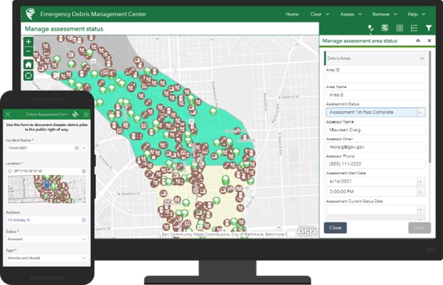
To manage and visualize the data for CDR Maguire, Blue Raster configured an ArcGIS Experience Builder Reviewer Tool. Utilizing this tool, field contractors can submit field survey forms to develop initial damage reports. The Experience Builder Dashboard provides real-time data to increase oversight and efficiency. These methods provide CDR Maguire with accurate data collection for FEMA reimbursement requirements. Throughout this project, the CDR Maguire team was knowledgeable and a collaborative partner to ensure that a workable solution was created.
Example of ArcGIS Emergency Debris Management Solution, courtesy Esri
While this solution was initially developed to assist in the removal of debris from the Boulder County Marshall Fire, this technology has already been employed to address a similar situation following a wildfire in Texas. The applications of this solution translate to a multitude of circumstances in which the efficiency of response can allow for a swift reaction to any type of natural or man-made catalyst.
- Posted in
- Disaster Response
- ArcGIS Experience Builder
- ArcGIS Online
- Esri
- Field Mobility
- Infrastructure
- Mobile
- Public Safety
- Survey123
Related Posts
- Driving Forward with VDOT’s Integrated Directional Signing Program
- Transitioning from Web AppBuilder to Experience Builder: Get Ready for a New Experience
- Field Trial Success: Farming Sustainability With Esri Collector and ArcGIS Online
- TrailsMV Mobile Application: Explore Martha’s Vineyard’s Nature Trails
- Esri ArcGIS Cloud Specialty: Elevating our clients’ GIS capabilities to the sky
