Global Forest Watch – Commodities is proud to announce the integration of the PALM Risk Tool (Prioritizing Areas, Landscapes and Mills), a groundbreaking tool aiming to eliminate deforestation surrounding palm oil production across Indonesia, Malaysia and elsewhere. With a global data set of nearly 800 palm oil mills, corporations have for the first time the resources needed to commit to deforestation-free palm oil sourcing.
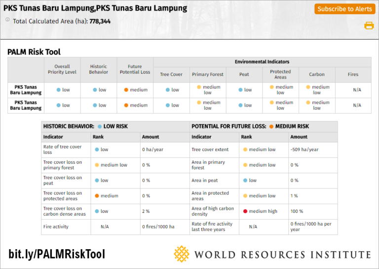 To make this tool successful in real-time, the application utilizes satellite-based data alongside regularly updated mill data. Users can select one or multiple mill sites, and analyze data surrounding this location for fire activity, tree cover loss, and high-carbon peatlands. Based on this analysis, rankings are calculated to create a more focused and efficient approach to sustainable palm oil production.
The maps utilize ArcGIS for Server while the code base integrates ArcGIS JavaScript API, Highcharts, and React JS, all working together to power an application that is accessible and reliable. In order to support the advanced analysis done on-the-fly, the application uses the ArcGIS Image Server extension and compute-histograms tools.
 “Companies have made ambitious commitments to remove deforestation from their supply chains, yet significant challenges exist to turning these commitments into action. The PALM risk tool helps address this challenge. Commodity traders and buyers can use the tool to identify the mill areas of highest priority in their supply chain in order to intervene and in turn, get the biggest bang for their buck. The tool leverages the powerful data of Global Forest Watch together with dynamic analysis in ArcGIS, allowing companies to analyze their own supply chain — as well as the first-ever mill dataset hosted by GFW — to begin moving towards their zero-deforestation goals.”
-Sarah Lake, Corporate Engagement Research Analyst, Global Forest Watch