Our Work

Blue Raster helps you tell your story through interactive
mapping technology. Make your message clear, exciting,
and user-friendly for both mobile and web platforms.

Tag: ArcGIS Server Flex API

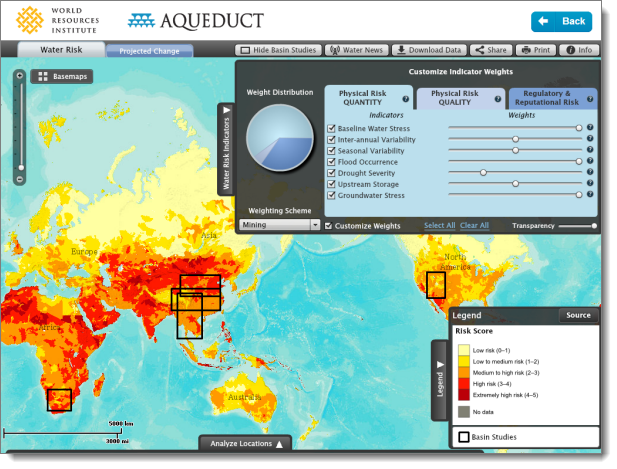
Aqueduct – Mapping Water Risk Around the Globe

Blue Raster and the World Resources Institute (WRI) recently launched the latest version of Aqueduct Atlas, helping businesses around the world understand the impacts of a sustainable water supply.

The platform creates customizable, multi-variable maps that display twelve indicators of water risk in a given area, including groundwater stress levels, drought intensity, and flood occurrence. It also considers less obvious risks like legislation and regulatory limits to water access.

This information helps companies, investors, and other decision-makers:

  • Prioritize investments that will increase water security
  • Learn how water stress will affect their operations
  • Assess risk and target new opportunities worldwide

To map their priorities, users can adjust the weight of the water risk variables. The maps also have settings for nine water-intense industry sectors, including energy, agriculture, and chemical. Geocoding allows users to plot facilities, suppliers, and potential new market locations.

Aqueduct Water Risk Atlas

Built on ArcGIS Server 10.1, the tool takes advantage of the new “dynamic layers” capability to allow rapid rendering of more than 25,000 polygons to depict the topology of catchment areas.

Major companies around the world are already using Aqueduct to inform operations:

  • McDonalds is requiring hundreds of its suppliers to use Aqueduct to assess local water risk
  • Procter & Gamble used Aqueduct to understand how water risk may affect its global facilities
  • Bank of America Merrill Lynch used Aqueduct to illustrate water risks and opportunities for investors

“Recent history is littered with companies that failed to anticipate emerging threats. Water scarcity is one such threat,” said Andrew Steer, President of WRI. “Thankfully, forward-thinking business leaders are starting to get it. They understand that water risk is one of the top issues that they face.”

Aqueduct has received extensive media coverage, including in the New York Times, The Guardian, Fast Company, Bloomberg, and Greenbiz.

Aqueduct allows users to easily see water risk around the world. Come check out this new decision-support tool.

Increasing Forest Transparency in the Congo Basin

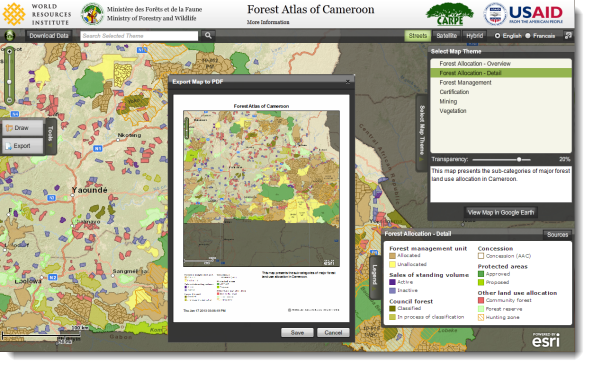
Current information relating to land rights, agriculture, and forestry in Cameroon is now easily accessed with the development of the Cameroon Interactive Forest Atlas, produced by Blue Raster in collaboration with the World Resources Institute.

The Atlas combines the use of remote sensing, mapping, and ground-truthing to monitor and manage forests. Stakeholders can access timely and accurate information about land use allocation within the national forest estate (forest concessions, protected areas, council forests, community forests, etc.) through the Forest Atlas. The goal of the project is to place forest information securely into public hands to support transparent and participatory decision making towards sustainable forest management in Cameroon.

Forest Atlas of Cameroon

For Cameroon, WRI aimed to play a role in supporting environmental protection and promote responsible population development, economic growth, and use of local resources by providing a clearer picture when discussing local environmental issues and greater socio-economic issues for the nation.

In supporting that goal, Blue Raster was charged with creating a multilingual user-friendly application for accessing this detailed information on the local forestry infrastructure.  Using GIS data, the Cameroon Interactive Forest Atlas displays information on concessions and boundaries, better explains the legality of logging in specific regions, and reveals areas of responsible mining and agriculture.  For analysis, the data can be overlaid on satellite imagery giving the user both a current and clear visualization of the area.

“The Forest Atlases are an essential contribution towards improving the management and monitoring of forest lands across the Congo Basin.  Through the online and offline Atlas applications, users can easily access up-to-date forest information without any technical training – significantly lowering barriers for turning information into action”, comments Matthew Steil, Manager, People and Ecosystems at World Resources Institute.

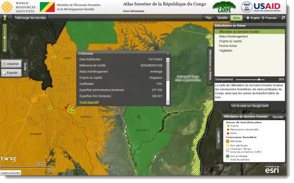
Forest Atlas of the Republic of Congo

In addition to the interactive web application, an Offline Atlas is available for use in the field or for those without access to a reliable internet connection.  This downloadable version, as well as charts, maps, and a poster of the region, can be utilized remotely, giving users the mobility they require.  Blue Raster continues to work with WRI and Ministry of Forestry to create similar Atlas applications for other nations, including:

With support from USAID, WRI promotes responsible economic growth alongside environmental protection in developing regions.  Through continued collaboration between WRI and Cameroon Ministry of Forests and Fauna, Blue Raster will continue to contribute to this project by updating it regularly, giving users access to the most current and accurate information available to promote the objectives of WRI in the Congo Basin.

The following press releases are available for additional information:


Page 1 of 6