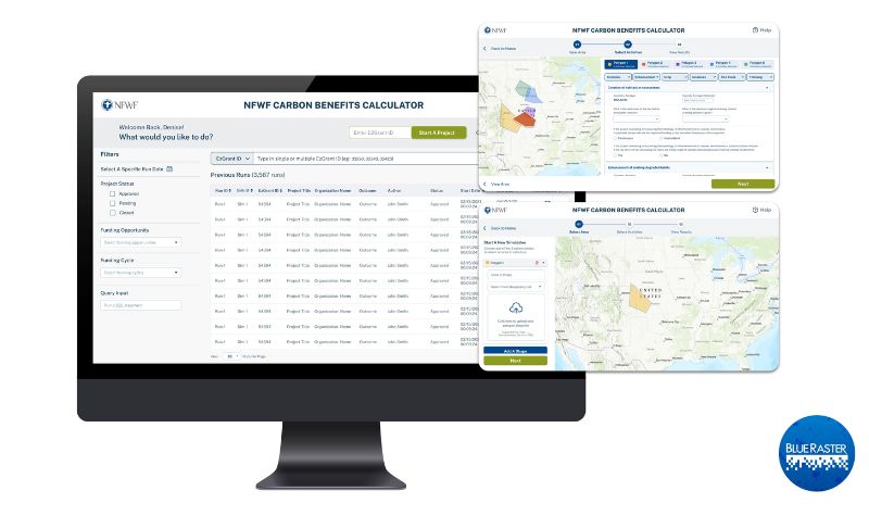
Most of our daily activities create greenhouse gas emissions which exacerbate climate change. Organizations like the National Fish and Wildlife Foundation (NFWF) spearhead efforts to mitigate these negative impacts by funding initiatives that offset emissions and create a greener earth. Blue Raster partnered with NFWF to create a robust Carbon Benefits Calculator. This tool estimates and visualizes the carbon impact of past and planned conservation efforts, restoration, and improved land management activities of NFWF.

NFWF wanted to innovate and optimize their existing in-house carbon calculator tool that was hosted in Excel. Blue Raster understands the need for a spatially explicit, robust tool that provides real-time calculations and eliminates hard-coded values to improve usability and usefulness. Additionally, this new tool enables NFWF to assess activities in various locations over different time series quickly and easily.
Our team created a web application backed by geoprocessing services in Python scripts. The tool allows a user to upload a spatial polygon for an area of interest to calculate carbon benefits, expanding the previous functionality that only allowed analysis at the county level. These calculations are done with python logic and geoprocessing services that are uploaded to ArcGIS Enterprise. Converting the tool from a spreadsheet-based calculator to a real-time and streamlined web application allowed for faster, easier, and more comparable results.


This tool uses various raster datasets including national land cover and carbon stocks to calculate the different properties and values such as climate, location, size, carbon stock, and land cover of the user submitted area of interest. Then, the tool automatically takes those values from the raster data and calculates the carbon benefits that would result from the selected project. NFWF can use this tool to estimate the carbon benefits of various projects and events such as invasive species clearing, crop and livestock use, thinning, fires, land transformations, over a 30-year period.
Previously, Blue Raster built out the Where We Work web map for NFWF to help illustrate the extensive geographic reach of their mission and impact of their conservation programs. Also, we built a proposal reviewer application and aided in NFWF's ArcGIS Enterprise installation.
We are excited to continue our collaborative efforts and work with a long-time partner by supporting NFWF with the Carbon Benefits Calculator and ongoing conservation efforts.
Ready to find out more?
We are excited to be a part of another non-profit's ongoing conservation and restoration efforts! Contact us today to learn how we can help your organization.


