Our Work

Blue Raster helps you tell your story through interactive
mapping technology. Make your message clear, exciting,
and user-friendly for both mobile and web platforms.

Tag: Flickr

NFWF maps 12K Conservation Grants with ArcGIS

To help illustrate the extensive geographic reach of their mission and impact of their conservation programs, Blue Raster built the Where We Work web map for the National Fish and Wildlife Foundation (NFWF). The mapping application allows supporters to visualize where NFWF is working and learn more about individual grants of interest. Matt Foster, Monitoring and Biodiversity Officer at NFWF, has this to say about the map – “The interactive map showing NFWF projects over the past 30 years is a great asset.  It really helps to convey the breadth of NFWF work in the U.S. and around the world and describes the wide range of actions that we support.”

NFWF Grant Mapper

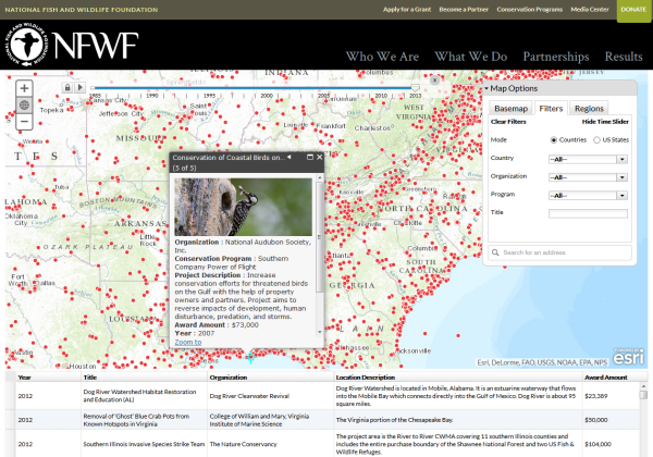
Built on ArcGIS for Server using the ArcGIS API for JavaScript, NFWF’s Where We Work map allows filtering based on time, location, and various other grant attributes including the associated conservation program. The Flickr API provides images for the various projects.

The National Fish and Wildlife Foundation (NFWF) is a Congressionally-chartered foundation, specifically charged with the administration of monies to “further the conservation and management of fish, wildlife, plants, and other natural resources” of the United States (National Fish and Wildlife Foundation Establishment Act, 16 U.S.C. §3701 et seq.). Since 1984, NFWF has become one of the world’s largest conservation grant-makers with more than 12,100 grants totaling over $2.1 billion.

WildFinder Advances Knowledge of Species Biodiversity

To promote understanding of global species biodiversity and conservation, World Wildlife Fund partnered with Blue Raster to launch an updated version of WildFinder.  This online mapping application provides conservationists, educators, students and concerned global citizens with enhanced ability to study the global distribution of more than 26,000 species.

WildFinder gives users the ability to visualize and investigate the world’s most comprehensive dataset of the geographic distributions of birds, mammals, reptiles and amphibians. Scientists have used WildFinder to conduct research that otherwise would have required a time-consuming search of hundreds of references.  This interactive application provides the ability to search for wildlife by location, species name (common or scientific) and ecoregions.  Users can explore a variety of thematic ecoregion maps such as terrestrial biomes, species endemism and richness, as well as freshwater and terrestrial rarity, providing geographic context to user queries.

New features in this latest version of WildFinder include increased visualization and context for both species and ecoregions through photos from Flickr and Arkive, new thematic maps, details on ecoregions and updated threat status information for species. The application applies the technologies of ESRI ArcGIS Server, Oracle, and Adobe ColdFusion as well as the Flickr and ARKive APIs.


Page 1 of 2