Our Work

Blue Raster helps you tell your story through interactive
mapping technology. Make your message clear, exciting,
and user-friendly for both mobile and web platforms.

Tag: Oil Palm

Supporting Sustainable Palm Oil in Indonesia

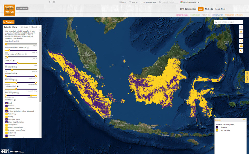
The World Resources Institute (WRI) is launching two powerful online mapping applications that offer unprecedented capabilities to support industry and government efforts to achieve more sustainable palm oil production in Indonesia.  The Suitability Mapper helps users find potential sites for sustainable palm oil production, using a customizable map. It empowers companies and government planners to use a standard, easily replicable method to find potential sites for sustainable palm oil production and plan field assessments for further investigation.  The Forest Cover Analyzer allows users to view change in forest cover over time in areas of their choice, using up-to-date satellite data.  It provides a unique set of monitoring tools to help buyers, investors, and governments strengthen incentives for avoiding deforestation when developing new plantations.

“Palm oil holds tremendous opportunities for people and business in Indonesia—and should be produced in a way that avoids destruction of vibrant lands and forests,” said Andrew Steer, President of WRI. “These dynamic new online tools will enable companies to better identify the best places for palm oil production and assess deforestation and other factors that are critical for long-term sustainability of this industry.”

Suitability Map in GFW Commodities


Preserving Rainforests with Project POTICO

To preserve endangered rainforests in Indonesia, the World Resources Institute (WRI) has launched Project POTICO (Palm Oil, Timber, Carbon Offsets), a revolutionary approach to ecosystem management.  Working with spatial analysis tools developed by Blue Raster, Project POTICO aims to divert planned oil palm plantations away from virgin tropical forests to already degraded lands, a swap that will prevent deforestation, reduce greenhouse gas emissions, and encourage sustainable agricultural development.

Using the Suitability Mapper, Project POTICO is mapping degraded lands in West Kalimantan, Indonesia, to identify areas with high potential for sustainable oil palm expansion.  This interactive web application produces a customized map of potentially suitable locations based on user inputs and a methodology developed by the WRI and its local partner Sekala.  The custom maps can be used by government officials for land-use planning and zoning decisions and by oil palm companies to prioritize areas for project-specific field assessments. To create these custom maps, the application uses Esri ArcGIS Server Flex API and Pixel Bender for geoprocessing directly in the browser.

Blue Raster also developed the Forest Cover Analyzer, which supports Project POTICO’s efforts to monitor changes to the forest cover.  Using this application, government agencies and nongovernmental organizations can compare current and historic satellite imagery of Indonesian forests, and determine if oil palm companies are using degraded lands and meeting the standards of the Roundtable on Sustainable Palm Oil.  In addition to using Esri ArcGIS Server Flex API, the application uses the Flickr API, allowing users to explore over 190 field points and panoramic images collected to verify maps.

The beta versions of these two websites were presented at the Roundtable on Sustainable Palm Oil conference in Malaysia November 2011 and feedback collected from this event will be used to inform revisions to the public website to be launched in 2012.  For more information on the project please contact beth.gingold@wri.org.