Tag: PhoneGap

Mapping the Global Adoption of Digital Media

The explosion of digital media has created new ways to distribute news and information with global audiences. Events in almost any location can be shared immediately with citizens in the remote corners of the developing world.  Although this digital revolution holds promise for organizations that support freedom of expression and balanced news coverage, it also presents challenges, such as bridging the digital divide between prosperous and impoverished communities.

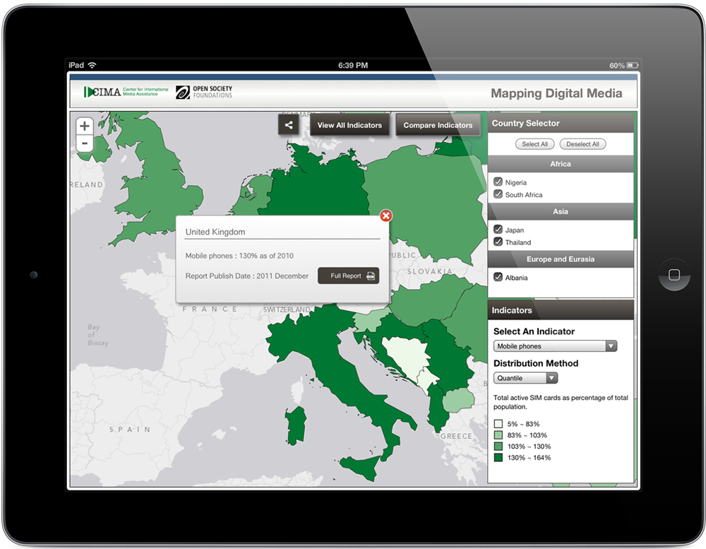
The Center for International Media Assistance (CIMA) at the National Endowment for Democracy partnered with Blue Raster to develop an interactive map featuring 10 digital media indicators from Open Society Foundations‘ Mapping Digital Media project. The project examines the global opportunities and risks created by the transition from traditional to digital media. Covering 60 countries, the project includes data on how these changes affect news about political, economic, and social affairs.

Using this interactive web map, visitors can view indicators of digital media penetration and usage by country.  Selected indicators include television consumption, digital broadcasting, internet penetration, broadband, mobile phone and social media usage.  The indicator data is drawn from the Mapping Digital Media project reports, which were researched and written by teams of in-country academics and journalists.  Users can quickly view all 10 indicators from these reports or compare specific indicators across countries of interest.  The tool also encourages users to share new information via social media.  By making the Mapping Digital Media tool available to the public, CIMA hopes to expand the conversation about its mission to strengthen the support, raise the visibility, and improve the effectiveness of independent media development throughout the world.

The application, accessible on both desktop and mobile devices, was built utilizing ArcGIS Online, the Esri JavaScript API and HTML5.  Blue Raster also used Adobe PhoneGap to create an iPad version of the map, which is available for download from the Apple App Store.

CIMA - Mapping Digital Media

App Store

On the Go: USAID MEASURE DHS Data Available in New Mobile App

With pressure to base policies and programs on meticulously collected data, there is a need to make USAID funded Monitoring and Evaluation to Assess and Use Results Demographic and Health Surveys (MEASURE DHS) reports more readily available.  However, many developing countries have no access to a tangible library of DHS reports, nor a reliable internet connection to visit the MEASURE DHS website to access these surveys.

Luckily, the rapid increase in the mobile phone and smartphone usage  has given the MEASURE DHS team hope.  The popularity of these devices can grant anyone access to DHS reports, from policy makers in Washington, D.C. to remote communities in rural Africa.  In fact, according to Pingdom’s STATcounter, 15% of Africa’s internet browsing in May 2012 came from mobile devices, an increase of more than 150% from 2010.

With the help of MEASURE DHS technology partner, Blue Raster, the DHS Mobile application was developed.  MEASURE DHS mobile covers over ninety countries, including data on vaccination, childhood mortality, nutrition, HIV testing and prevalence, literacy rates, twenty other indicators.  It displays trends within a single country through Quickstats, and allows users to compare and contrast the most common indicators through a series of tables, charts and maps.  It also provides basic information about the individual surveys, such as sample size, timing, and topics included, and links to download the final reports, Key Findings, and fact sheets.

Recognizing the need to build an application that is available on multiple mobile platforms, Blue Raster, an Adobe Partner, utilized Adobe PhoneGap to compile both iOS and Android applications.  PhoneGap Build allowed Blue Raster to capitalize on their experience in web-standard technologies such as HTML5, CSS3 and Javascript to rapidly build and deploy the app.  Spatial data is delivered to the app using the ArcGIS 10.1 platform.  Basemap tiles are accessed from ArcGIS Server and ArcGIS Online, and the Esri Javascript API was used to link the geometry and data.

The app also stores all the indicator and survey data locally on the device, and periodically checks for updates.  This functionality truly enables users to connect with the data, despite the absence of consistent internet, and allows policymakers and program managers to visit field sites without having to create massive, tangible copies of data or abandon the data completely.

The DHS mobile application is free and available for Apple iOS (iPhone and iPad) and Android smartphones and tablets.  Blue Raster will work with the MEASURE DHS team to enhance the application with new features and continue to improve the user experience in the coming months.  For suggestions in improving the DHS Mobile application, please email mobile@measuredhs.com.


iTunes App Store Google Play


Page 2 of 2