Blue Raster partnered with Buffalo Olmsted Parks Conservancy (BOPC) to develop the South Park Arboretum Plant Finder application using ArcGIS Experience Builder and assist in the data management of South Park Arboretum’s “outdoor museum of trees”. With the launch of their new website on November 10th, visitors to the arboretum will have a new tool in hand that allows them to explore individual plant records, search information about featured plantings, get restoration project updates, and learn how South Park Arboretum staff are mitigating and managing invasive species on the property.

Plant Finder Application Developed with ArcGIS Experience Builder
Historic Restoration of South Park Arboretum
Located in Buffalo, New York and unique to the historic Olmsted park and parkway system is South Park Arboretum, an arboretum that was on par with the most notable arboreta of the late 19th century and early 20th century. The multi-year, eleven phase restoration of the South Park Arboretum, consisting of 155 acres of historic and culturally significant "Olmstedian" character-defining features, including approximately 400 “Olmsted Original” or heritage trees, is an exceptional feat, requiring significant oversight and planning. The vision behind the restoration is to capture and integrate Olmsted’s original design into the current park by selective plant evaluation for their contribution to the collection including plant removal, cultivation, and care of “Olmsted Original” trees that support the original taxonomical organization that the Olmsted design established in 1895.

ArcGIS Experience Builder Mobile View of Plant Finder Application
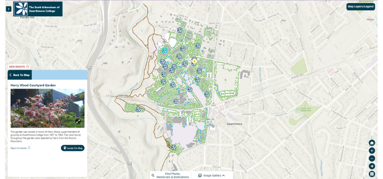
Developing Plant Finder with ArcGIS Experience Builder
Blue Raster established an ArcGIS Online environment for BOPC by leveraging their status as a non-profit for reduced software costs. We then assisted with preparing and publishing data and identifying additional datasets of interest. Blue Raster successfully ingested plant records data into our plant synchronization workflow – which automates updates from BG-BASE, the organization's botanical repository, into GIS. This workflow provides staff with the ability to make data modifications in the field, while pushing the data back to the system of record seamlessly.
After finishing the backend data workflows, Blue Raster designed and developed an ArcGIS Experience Builder application for both internal and public use. The application contains filters, queries, and navigational tabs for users to identify trees of interest, facilities information, featured photos and plantings, reference data such as Olmsted’s original 1895 Planting Plan, and a survey for visitor feedback. As the application was developed with a mobile-friendly design in mind, users can easily use the tool while on the grounds to navigate and find relevant information.
When working to finalize the Plant Finder mapping application to coincide with the launch of the new website, South Park Arboretum’s Director and Curator, Margaret Lapp, had this to say about the efforts to make their data more accessible for staff and the public by utilizing GIS
“Partnering with Blue Raster and BG-BASE has proven invaluable to the Arboretum’s overall restoration and awareness-building efforts. GIS enables South Park Arboretum to integrate collections documentation with geographically referenced information supporting tree care, its coordination and curation alongside public enjoyment and discovery. The launch of the Plant Finder App. is a testament to Frederick Law Olmsted’s democratic and inclusive principles and transcends time in upholding Olmsted’s vision—to create an Arboretum where visitors could observe and learn about plants. BOPC is absolutely delighted to share our plant collection with the community near and far, fostering a spirit of curiosity for the natural world.”
- Margaret Lapp, Director and Curator, South Park Arboretum

Plant Finder Application Developed with ArcGIS Experience Builder
Learn More About Blue Raster's Work with Public Gardens and Arboreta
Blue Raster is an Esri Gold Business Partner and Nonprofit Specialty holder. Blue Raster is excited to support Public Gardens clients and bring awareness to some of the most beautiful and historic public spaces. Learn more about Blue Raster’s long history working with Public Gardens on innovative GIS solutions for staff and the public.