Our Work

Blue Raster helps you tell your story through interactive
mapping technology. Make your message clear, exciting,
and user-friendly for both mobile and web platforms.

Tag: World Bank

GIS for Community Engagement with the World Bank

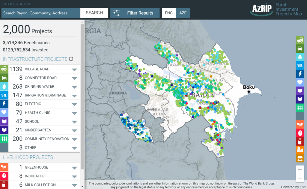
With over 2,000 projects benefiting 3.5 million people, the Azerbaijan Rural Invest Project (AzRIP) launched by the World Bank has been extremely successful in advancing the lives of everyday people by improving infrastructure in rural areas. Since its launch in 2005, the World Bank has assisted in a variety of projects including improving road conditions, health clinics and schools, and access to clean water. With so many projects across the 56 Rayons of Azerbaijan, Blue Raster was eager to help them create a map that had two goals: provide the Azerbaijani citizens a window into AzRIP's activities within the community and help investment teams make more focused, data-driven decisions.

A Commitment to Success

The World Bank has a commitment to success: each project works towards eradicating extreme poverty and promoting shared prosperity. The development of this web application is crucial to increase the community engagement of those benefiting from the investments, and we need to know what works when it comes to impacting everyday lives.

The application allows users to easily search by the type of investment project, with symbology that immediately translates the spread of certain types of investment projects and how these exist within communities and across borders. Also important was the ability to search by Rayon, year, and number of beneficiaries, to help understand the progression of these projects over time.

The Right Product

Because the projects are continuously evolving, Blue Raster worked with the World Bank to find a GIS solution providing organizational access to and ongoing management of the map. The Map is built utilizing ArcGIS Online, a complete, cloud-based mapping program that delivers these institutional requirements.  ArcGIS API for JavaScript provides the web framework for robust data visualization and data editing.

Throughout the development and launch of the application, Blue Raster assisted with international launch events attended by top government officials and stakeholders.  We love to meet the people who can use the application in their everyday lives and show them the power of mapping.

World Bank Georesults: Interactive Maps for Project Storytelling

Blue Raster and the World Bank Institute teamed up to create Georesults, an online mapping tool that allows users to learn about World Bank projects from an on-the-ground perspective via images, videos, and stories.

With this innovative tool, World Bank staff are able to document, contextualize, and share development solutions via interactive multimedia, an accessible alternative to conventional project reports that are often long and technical.

Georesults is an extension of the World Bank’s Mapping for Results initiative, founded in 2010, which aims to better monitor the impact of and offer local perspectives on Bank-financed aid projects at the sub-national level. Georesults’ interactive depictions of progress in local communities will help the World Bank track the effectiveness of its work and promote transparency and accountability.

“Inspired by our close collaboration with project managers and their teams, we ideated and are piloting this new approach of showing progress of World Bank results, connecting people to Georesults (beta) via the Mapping Platform,” said Aleem Walji, Director of Innovation Labs in WBI.”

Storytelling alternatives within the Georesults system include sequences of text and photos to illustrate events; before-and-after images that reveal results; and video clips offering an intimate peek into on-the-ground action. Users can browse project sites by location on a world map or search by project ID.

The concept is based on Esri Story Maps, a platform for joining online mapping with interactive content. The application uses ArcGIS Online, Esri JavaScript API, Flickr, and YouTube. No programming or content management systems are required, so that World Bank staff can populate the system by uploading content to arcgis.com and tagging images using existing multimedia platforms.

The World Bank has taken this app offline.


Page 1 of 2