Blue Raster has been working with public gardens, arboreta, and cemeteries since 2010.
We develop solutions for internal staff workflows and powerful tools for researchers
and the public to explore your plant records.
Blue Raster has been working with public gardens, arboreta, and cemeteries since 2010. We are experts in design, visualization, and analysis of data through highly interactive applications built on the ArcGIS Platform. We develop solutions for internal staff workflows and powerful tools for researchers and the public to explore your plant records. However you currently manage your data (BG-BASE, IrisBG, Excel, GIS, etc.) we can integrate with your setup. Whether your garden is large or small your story is important to us and our dedicated team is experienced in implementing professionally designed tools and workflows to share with the world.
■ ArcGIS Setup, Support & Training
■ GIS Data Creation & Conversion
■ Plant Records Mapping
■ Work Order Management
■ Web and Mobile App Design & Development
■ Drone Basemaps & Asset Inspection
■ Analysis and Visualization
■ BG-Base to ArcGIS Real-Time Sync
Blue Raster understands the importance of using an application at the source. For public and staff workflows that often is outside amongst the gardens and collections. Whether designing an experience for an App Store application or a mobile browser, how the application functions in a mobile setting is key. Blue Raster designs and develops powerful yet intuitive applications optimized for mobile use. Some highlights of recent work include:
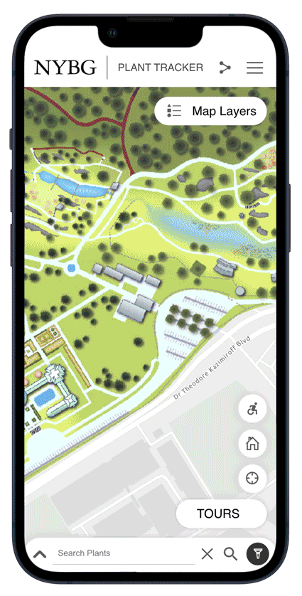
New York Botanical Gardens - Plant Tracker (responsive web app)
Plant Tracker is a powerful search tool for the public and staff alike. Whether on the grounds or at home, Plant Tracker users can browse, search, and filter NYBG's vast collection of 140,000 living and non-living records across 25+ garden location and almost 700 sub locations.
Complete with photos of the plant species, key points of interest and visitor amenities, as well as staff-curated tours, Plant Tracker enhances the experience of guests on the grounds or remotely. PlantTracker replaces the legacy Garden Navigator application and provides an enhanced user experience with a map-centric and mobile-first design.
Read More
Green-Wood Cemetery Mobile (Native iOS & Android App)
Spanning almost 500 acres in densely populated Brooklyn, New York, Green-Wood Cemetery is one of America's first rural cemeteries. Founded in 1838 and today a National Historic Landmark and accredited arboretum, Green-Wood attracts over 500,000 visitors annually. People come to see the beauty of the trees and monuments, and immerse themselves in the history of many famous people buried there.
To help visitors navigate the grounds, Blue Raster developed the Green-Wood mobile app. Using React Native allowed for rapid development for both iOS and Android platforms, and the map and search functionality was developed using Esri's ArcGIS API for JavaScript.
This fun-to-use and informative application allows users to view profiles of landmark monuments and structures, learn about the diverse plant and animal species that live on the grounds, and discover stories of the famous and infamous people buried there. Additionally, the map allows users position themselves on the grounds and find an area of interest. Filter the map points by popular categories and link out to the expanded profiles.
Read More
United States National Arboretum Mobile (Native iOS & Android App)
Blue Raster has been working with the U.S. National Arboretum since launching the Arboretum Botanical Explorer (ABE) in 2012. To complement ABE and enhance the user experience for visitors on the grounds, Blue Raster developed the mobile version of ABE and launched in Spring 2017. Developed using AppStudio for ArcGIS, the application is available from the Apple and Google Play stores. The mobile app allows users to locate themselves on the grounds, easily find information about ongoing exhibits, as well as locate visitor services such as parking, restrooms and water fountains. Roam the grounds freely or take advantage of many pre-defined tours sized just right for the time you have, complete with individual stops, photos and descriptions. For those looking to dig even deeper, individual plants records are displayed on the map and searchable by Name or Accession Number, and extensive scientific data are included for much of the collection.
 BG-BASE
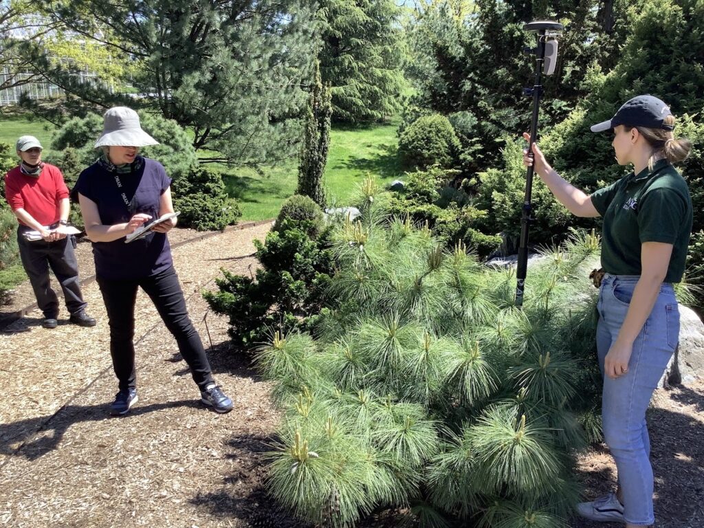
Blue Raster works with multiple gardens to implement a live sync between BG-BASE and ArcGIS. Using the API developed by BG-BASE, certain plant record updates or new accessions appear in GIS immediately. Using ArcGIS Field Maps, changes to plant location, condition or measurement information can be pushed to BG-BASE directly from the field. This reduces data entry in multiple platforms, reduces error in entry, and allows data to be live in both systems in real-time.
Work Order Assignments
For internal use at public gardens and cemeteries, Blue Raster has developed a workflow to capture work order assignments in the field and push on a schedule to ArcGIS Workforce for assignment and completion. Whether it is plant maintenance or monument restoration, assignments on individual trees or headstones, or at the garden or lot level can be created in minutes. Email notifications can be configured based on assignment priority or due date. Related table structure in GIS shows the work order history of a plant or monument.
Real-Time Dashboards
Knowing the status of completed or in-progress work orders at any moment is key insight. Blue Raster can help take your work order assignments and configure ArcGIS Dashboards to filter the records by assignment type, maintenance crew, date completed, and more. Indicators, lists, charts and graphs, along with an interactive map make these dashboards valuable for real-time reporting or generating weekly, monthly or annual reports.
Blue Raster are experts at designing and developing highly interactive, map-centric web applications tailored for your unique garden. Rely on Powerful Technology - With Blue Raster's UI/UX designers and agile Developers, no job is too difficult or large. We integrate powerful technologies like JavaScript frameworks and mobile device emulators. At Blue Raster we believe in building an efficient process for all stages of development - from research, wireframing and prototyping all the way through development, testing and launch.
 United States National Arboretum Explorer (ABE)
Launched first in 2012 and redesigned in 2019 the Arboretum Botanical Explorer (ABE) at the U.S. National Arboretum offers something for everyone! For the public, browse the entire collection easily by common or scientific names. For more advanced plant queries use the structured search to filter data by names, origins and location, and special characteristics. The table results and individual plant popups contain a wealth of information great for researchers and staff with daily workflows. Beautiful images and the plant gallery, and points of interest and garden collections on the map round out the experience.
Read More
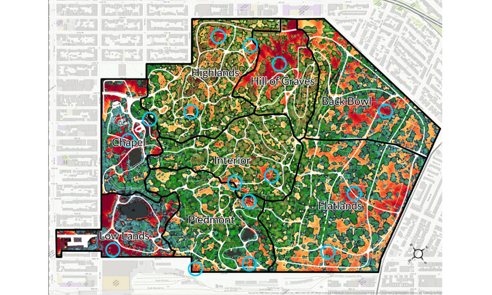
Flora at Mount Auburn Cemetery
At America's oldest Garden Cemetery the burial grounds and horticultural display deeply matter. Founded in 1831 in Cambridge, Massachusetts, Mount Auburn Cemetery spans 175 beautiful acres. Flora was developed for the public to engage both remotely and onsite. Multiple Tours offer insight into sustainable landscape practices, the lives of celebrated botanists and gardeners, or famous African American buried there. The plant search displays records on the map by Common, Scientific, or Family name, as well as habits and garden locations. And the map offers the ability for the user to navigate, see points of interest or trees of distinction, and turn on 360 cemetery imagery to view headstones and monuments if you can't be there in person.
The Scott Arboretum of Swarthmore College (Beta)
Blue Raster is actively working with Scott Arboretum to develop a Plant Explorer application. Build using the ArcGIS API for JavaScript, the application features an image gallery of points of interest, plant and heritage tree searches, staff-curated tours, and displays for memorials and dedications. Check back here for more updates and a link to the application once it goes live!


Let our dedicated team of GIS and application developer professionals help you today!