Tag: ArcGIS API for JavaScript

Exploring George Washington’s Mount Vernon in 3D

George Washington’s Mount Vernon home is a well-loved national treasure, meticulously studied by researchers, restored by preservationists, and visited by a million guests every year. It is the best-documented historic site in the nation, with a trove of information available about everything from the original builders and craftsmen of the house to the individual trees that lived on the grounds in George Washington’s day. Blue Raster shares this information to Mount Vernon’s patrons and stakeholders through an easy and intuitive website, in a partnership with the Mount Vernon Ladies’ Association (MVLA) and Quinn Evans Architects.

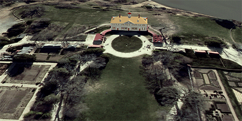
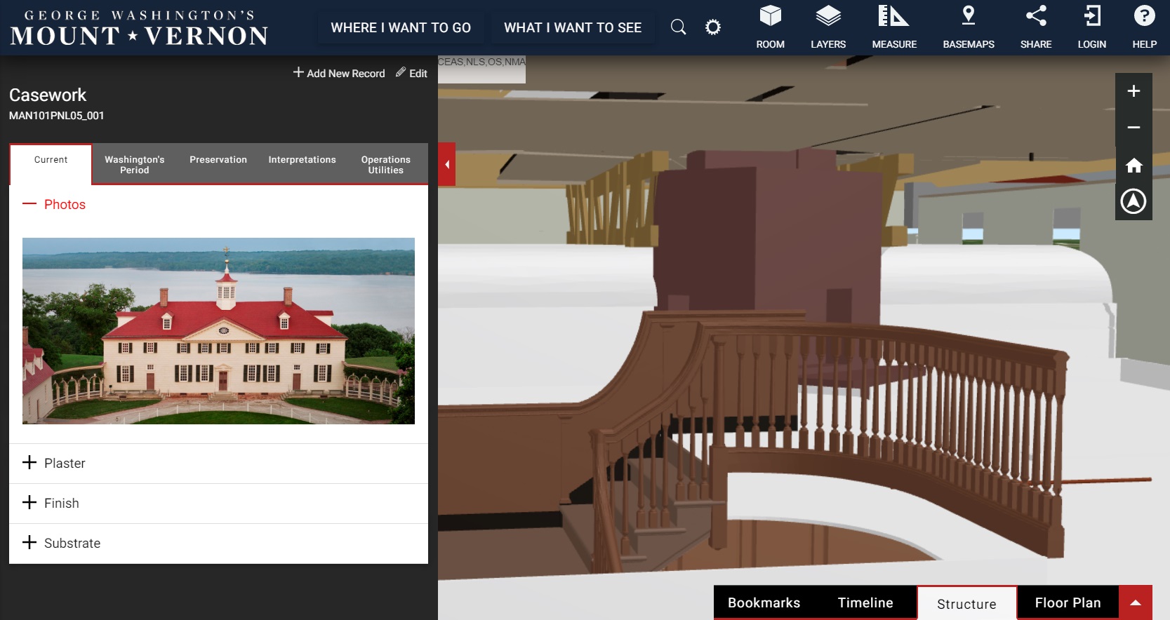
Blue Raster developed a prototype online 3D GIS portal for viewing the available spatial, structural, and background information associated with a historic building information model (HBIM) created by Quinn Evans Architects. This includes location information and 3-D modeling and will include details and documents associated with individual elements of the buildings and landscape once the content management system is complete. The tool will make the extensive historical documentation of the estate accessible to scholars, educators, and the public while improving its conservation and maintenance.

mt_vernon_outside

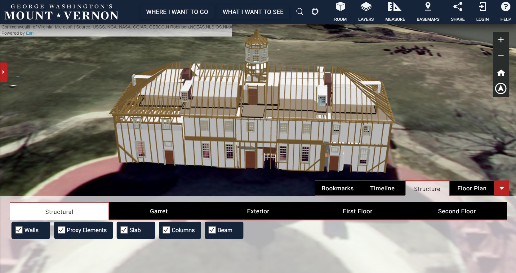
The web application leverages Esri’s ArcGIS API for JavaScript 4.0 and makes use of its WebScene class, allowing the user to virtually explore the estate while investigating documents and historical artifacts. Blue Raster also designed a custom user interface for the application, aligned with the Mount Vernon style guide. Users will now be able to view Mount Vernon and learn about its history in ways never possible before.

mt_vernon_inside

Be sure to take a look at this new 3D web application today, and explore the Mt Vernon property, inside and out!

Esri DevSummit 2017: The Science of Where

The Blue Raster team of GIS and developer superheroes had an inspiring week at the Esri Developers Summit in Palm Springs, California. The DevSummit is where we collaborate with developers and mapping experts from all over the world and learn about the latest ArcGIS platform capabilities, explore enhancements to advanced analysis of big data, and discover the most creative graphics and visualizations that bring data to life. Additionally, it gives us the opportunity to work one-on-one with Esri experts to dive deep into the software and brainstorm a variety of solutions best fit for our products.

Standout technological upgrades from our experts:

  • ArcGIS Enterprise - the next evolution of ArcGIS Server which includes a variety of compentents designed to work together as a dedicated web GIS infrastructure, including the support of Server and Enterprise architectures in AWS CloudFormation
  • Python - from the new ArcGIS Python API to publishing Geoprocessing tools, the integration of Python scripting is becoming a vital component to the processing and organization of spatial data
  • JavaScript - the latest tips and tricks for utilizing the ArcGIS API for JavaScript to handle big data, 3D visualizations, and more.

One of our lead developers, Lucas Cotner, believes that the DevSummit is fundamental in learning the latest technology and interacting with the GIS Community:

"The energy and expertise brought to Palm Springs never ceases to amaze me. There is a constant transfer of knowledge from the Esri staff to all the other attendees, each experts in their own ways. Our team is excited about exploring new solutions, as well as contributing and participating with things we have learned in the past year."

Several of our team members had the opportunity to present at DevSummit and bring some knowledge to the table. Eric Ashcroft presented during Esri’s Small Business Lightning Talks about “Best Practices in Agile Development and Program Management.” Christine Movius gave an awesome presentation about “How to Supercharge Your ArcGIS App’s Speed Using AWS CloudFront and Google Accelerated Mobile Pages (AMP).” Lucas Cotner and Christina Phang amazed the crowd with their presentation on our work with Global Forest Watch’s Map Builder, and how to create configurable map atlases using ArcGIS Server and ArcGIS Online.

And of course, the team had a lot of fun in Palm Springs and throughout the DevSummit participating in the infamous dodgeball tournament with two teams participating this year, Kitten Mittens and Paw Patrol. We also had a wonderful day of team bonding at the top of Mount San Jacinto State Park, 8,500 feet above Palm Springs with beatiful hiking and snowball fights.

Thank you to all our friends who came to our Blue Raster social at Oscar’s Café & Bar. We can’t wait for next year’s DevSummit!


Page 5 of 8