Tag: mobile

DHS Program Mobile App v2.0 Released

Blue Raster is excited to announce the release of the The DHS Program Mobile App v2.0. A more intuitive interface, offline data download feature and enhanced cartography are a few of the upgrades creating excitement around v2.0.

Here’s a first look at what’s new in this release.
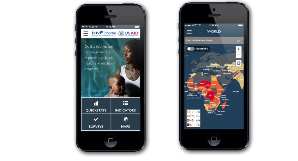
DHS-Mobile-2015-as-released_Compilation

125 indicators

Now when you use the app, you have access to 101 additional indicators — providing more than three times as much data than was previously accessible in v1.0. Behind the scenes, data is being supplied by the STATcompiler database through The DHS Program API. This ensures that you always have up-to-date data, even as new countries and indicators are added or adjusted.

Beautiful, clear design

We updated the look and feel of the app to give you a more compelling, intuitive user experience. We also revamped the maps to feature the latest in cartographic design allowing for better interpretation and clarity.

Take data offline

In v1.0, you could display trends for a single country through Quickstats and compare and contrast 25 preloaded indicators through a series of tables, charts and maps. Now v2.0 features the ability to download Quickstat data packages by country, making complete sets of data accessible even when offline. Through a combination of SQLite, Adobe PhoneGap, HTML5, AngularJS, and JavaScript, Blue Raster and The DHS Program are able to provide far more indicators offline to Android and iOS users.


Get the app for your device today.

Development Alert! Awareness of Infrastructure Projects

The World Resources Institute (WRI) and the Jamaica Environment Trust (JET) announced today the launch of the newest tool from WRI’s Access initiative, Development Alert!. Built by Blue Raster, the free, mobile-friendly site provides the public with greater access to information about development projects affecting the environment and public health. The site plots approved and proposed large-scale development projects along with overlays of protected areas, fisheries, forest reserves and land cover so users can easily identify projects in or around environmentally sensitive areas.

Development Alert Homepage


Development-Alert-On-iPhone-Map

In Jamaica, Development Alert! is helping promote transparency and public involvement in projects including the trans-shipment port in Goat Islands. The project is expected to flatten the Goat Islands to develop a $1.5 billion trans-shipment port.

Using the map of Jamaica in Development Alert!, members of the public can see that this project is not only located in a protected area but is also within a forest reserve and Special Fisheries Conservation Area.

See the Goat Islands Project in Action.


Carole Excell, Project Director, The Access Initiative“The dynamic new website Development Alert! Jamaica is the result of a close collaborative approach with Blue Raster. What has been accomplished is an innovative new advocacy tool for environmental defenders. It’s a first not only in Jamaica but in the entire Caribbean. We could not have asked for better partners in this project and hope to bring this website to other countries around the world.”

Carole Excell, Project Director of The Access Initiative at WRI


The site is developed on WordPress for easy content management by JET, and is integrated with ArcGIS Online and ArcGIS Server via the JavaScript API for mapping capabilities. Learn more and visit Development Alert!.


Page 6 of 9