Hailed as one of the country's most beautiful college campuses, Swarthmore College features more than 4,000 plant varieties and 425 acres of cultivated, flowering hills. As part of the breathtaking campus, the Scott Arboretum of Swarthmore College hosts numerous learning programs, extends incredible volunteer opportunities, and supports educational courses offered at the college. One of the arboretum’s central goals is to cultivate and display plants specific to the region and inspire visitors with ideas for their own gardens. Considering the volume of plants, frequency of plant updates, and educational purposes of the arboretum, a robust plant record management system and a publicly accessible application for exploration are integral to supporting Scott Arboretum’s ongoing mission.
In 2021, Blue Raster partnered with Scott Arboretum to establish a synchronization process between GIS and the arboretum’s botanical repository, BG-BASE. Another outcome was to update and modernize the arboretum’s public plant and dedication search site. Blue Raster created GIS data representing surveyed plant locations, garden features, points of interest, and other reference data for visitor amenities. The team also facilitated the expansion of field GIS for plant mapping by leveraging ArcGIS Field Maps to streamline and improve the efficiency of data collection and updates. The workflow enables internal staff and plant managers to modify and update plant records in the field while edits are committed to near real-time, allowing them to flow seamlessly into internal and public applications. The BG-BASE-ArcGIS sync exploits the powerful capabilities of Field and Web GIS in tandem with Python scripting for a continuous connection between the botanical system of record, GIS data, and associated information products.
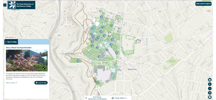
Finally, the new Arboretum Explorer application, developed in the latest version of the ArcGIS Maps SDK for JavaScript, is an interactive site for researchers, staff, and visitors to explore both the arboretum and campus attractions and filter and search for plants and memorials. The application enhances the user experience of engaging with the botanical database, enabling Scott Arboretum to thoroughly operate and present information to users. Arboretum Explorer is a dynamic application that highlights the arboretum’s garden collections, allowing users to identify dedicated benches and plaques, and other tools for navigating the historic gardens. As a mobile-friendly app, the Arboretum Explorer is a great resource for visitors to navigate and explore the collections while onsite.
"The Blue Raster team is incredibly knowledgeable, innovative, and amenable. They have the innate ability to take a basic concept and masterfully turn it into a functional, creative, and user-friendly end product."
- Mary Tipping, Curator and Plant Recorder, Scott Arboretum at Swarthmore College
Blue Raster has been supporting public garden, arboreta, and cemetery customers for over ten years, developing custom applications and providing training to increase the use of GIS for staff and public workflows. Click here to learn more about Blue Raster’s work with public gardens.