Cloud

Making Coastal Habitat Mapping Possible with Clark Labs

coastal habitat monitoring

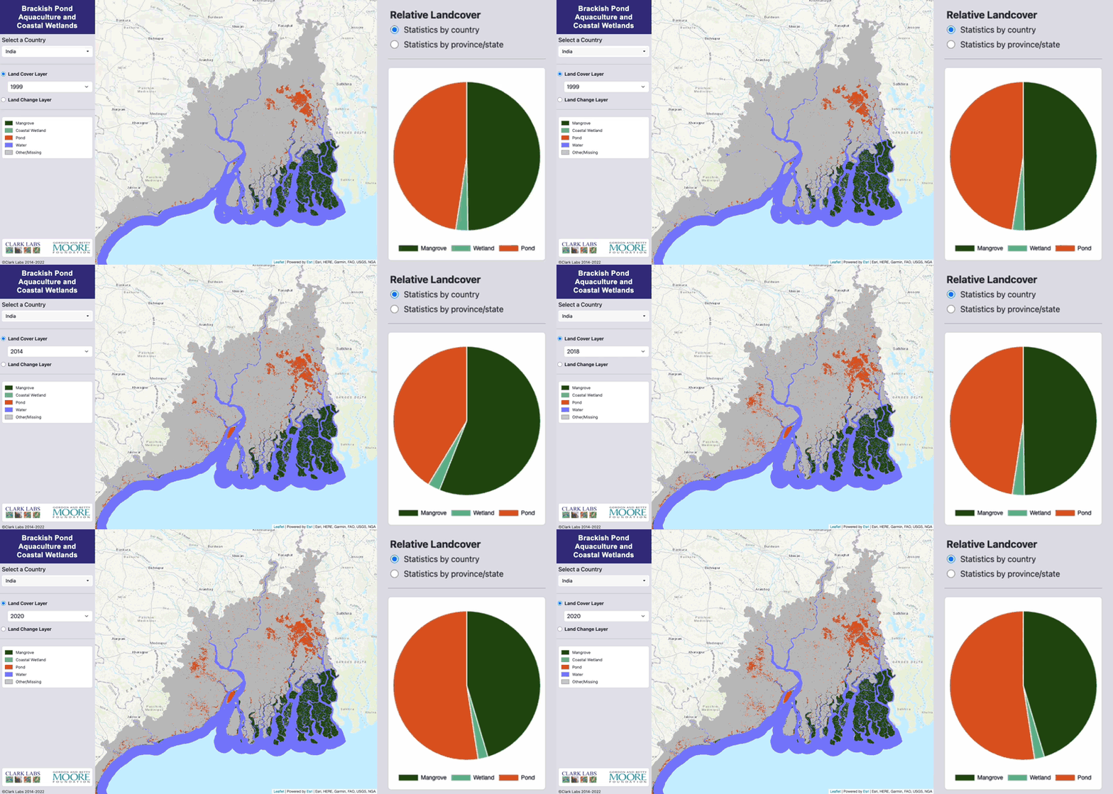
Blue Raster is helping Clark Labs, an entity of Clark University in Worcester, Massachusetts, with critical enhancements to its coastal habitat web mapping application that tracks and maps mangroves, pond aquaculture, and coastal habitats from all around the globe. Created in partnership with the Gordon and Betty Moore Foundation in support of the Foundation’s Oceans and Seafood Markets Initiative, the Brackish Pond Aquaculture and Coastal Wetlands interactive map will help to protect and conserve coastal habitats and marine life from overconsumption.

Task 1: Enhancements and Infrastructure Maintenance

The coastal habitat monitoring application was originally built using open-source technology; however, our expertise was requested to enhance the application to meet current industry standards using Esri technology. To start the process, we began with Amazon AWS Cloud and GeoServer infrastructure maintenance and enhancements. This task required stabilizing and improving the infrastructure for the coastal habitat web map application. To do so, our team completed the following requirements:

  • Ensured the SSL certificate was set up and renewed automatically.
  • Reviewed hosting security and software versions to confirm the site is secure.
  • Migrated the download function to CloudFront for improved user experience.

Clark Labs also wanted to simplify the aquaculture application, so our team implemented new services for improved data management, reduced cost, and better performance. This also included migration from GeoServer to ArcGIS Online to streamline management.

Task 2: Data Updates

After the infrastructure maintenance and application enhancements were made, the application was handed off to the backend team at Blue Raster. Data updates were established on an as-needed basis to the coastal habitat web map application, with Blue Raster providing guidance for updating Clark Labs' web map data content when a data update is available and ready for publishing. The application depends on Landsat imagery data to complete change detections for its interactive map, so it’s crucial for tracking purposes that the conversion data is updated accurately.

Task 3: Code Maintenance

Our Blue Raster developers also played a role in the code maintenance for the coastal habitat web map. They were responsible for reviewing existing web applications and publishing practices code to determine what could be reused and enhanced for Clark Labs’ application. Our developers revised existing software scripts where it was applicable, enacted performance improvements to the front-end user experience, and reviewed existing designs and flagged any updates that required alterations.

What's Next for the Coastal Habitat Web Map

Currently, the Blue Raster team is in the process of transferring the Brackish Pond Aquaculture and Coastal Wetlands web map from open-source technology to Esri technology, but the improved infrastructure, data updates, and current code maintenance will help us ensure that the web map application is functioning properly and providing users with a better-quality experience.

Explore Clark Labs’ Interactive Web Map for Brackish Pond Aquaculture and Coastal Wetlands >

Blue Raster Joins List of Pre-qualified Vendors for the North Carolina Department of Information and Technology

Blue Raster named a pre-qualified vendor for the purpose of providing GIS, cloud, and IT support to the North Carolina Department of Information Technology

Arlington, VA – April 21, 2023 - Blue Raster has been named a pre-qualified vendor for Geographic Information Systems (GIS) IT Specialty Services by the North Carolina Department of Information Technology (NCDIT). The contract is intended to develop a relationship between pre-qualified vendors and the state to provide information technology specialty services through subsequently issued Statements of Work for state agencies, community colleges, institutions, counties, municipalities, public schools, and other local government entities. Under this contract, Blue Raster has been approved to provide GIS, IT application development, cloud implementation, and cloud integration services.

To achieve pre-qualification, Blue Raster had to undergo an extensive and competitive application process in which specialty projects completed by each candidate were compared against current and hopeful pre-qualified vendors. The list was chosen out of over 70 new applicants.

“We are excited to expand our GIS and cloud capabilities to North Carolina via NCDIT,” says Michael Lippman, co-founder of Blue Raster. “We look forward to supporting innovation and geospatial solutions for the state, building upon the work we already support in the state with the City of Wilmington.”

As an approved vendor, Blue Raster looks forward to the opportunity to provide exceptional services to agencies across North Carolina under this contract.

About Blue Raster
Blue Raster develops award-winning, interactive web mapping applications that help its clients around the globe solve, clarify, and visualize many of the world’s critical challenges. Established in 2002 in Arlington, Virginia, Blue Raster works with the largest global organizations and government agencies in the fields of conservation, health, government, global affairs, and education.

Blue Raster partners with leading geospatial and information technology companies, including Esri, the world leader in geographic information system (GIS) software, and employs an experienced development and design team with expertise in web, graphic, and spatial technologies. To learn more, please visit blueraster.com.

Esri ArcGIS Cloud Specialty: Elevating our clients’ GIS capabilities to the sky

Blue Raster is thrilled to be a member of the Esri ArcGIS Cloud Services Specialty. This specialty designates Blue Raster as an expert in deploying and managing ArcGIS in cloud environments such as Amazon Web Services (AWS) and Microsoft Azure. The Cloud Specialty program is designed to help Esri connect customers with recognized Partners that can best provide ArcGIS cloud solutions. Partners that meet the criteria for this specialty must demonstrate a track record of delivering value to their customers in implementing, managing, and designing cloud infrastructure in the Esri ArcGIS environment.  

Esri Cloud Services Specialty

To attain this specialty, Esri assessed Blue Raster’s expertise in the following areas of ArcGIS Cloud services: cloud deployments, system architecture and design, migrations, and managed services. Our deployments of ArcGIS Enterprise in the cloud include routine monitoring and maintenance to allow us to fine tune the system as needed, ensuring reliability and performance. Our system architecture and design experience encompasses single machine and multi machine architectures in both AWS and Azure that are customized to our clients’ specifications. We support all types of migrations including on-premises to cloud provider migrations, ArcGIS Online to ArcGIS Enterprise, and integration with third party providers.

Our portfolio of managed services includes the utilization of a wealth of Esri products and tools in the ArcGIS family such as ArcGIS Enterprise, Data Store, GIS Server, GeoAnalytics Server, GeoEvent Server, Notebooks, Image Server, Pro, Monitor, and Enterprise Geodatabases. Implementing these tools empowers us to provide a number of managed cloud services to our clients including design consultation, server construction, Esri software installation, infrastructure troubleshooting, distributed systems configuration, geographic redundancy configuration, OS patching, Esri security patching, routine Esri patch deployment, DevOps services, and user training services, among others. Blue Raster is primed and ready to meet our clients’ needs in all areas of the Esri ArcGIS cloud.

ArcGIS Cloud Solutions by Blue Raster

With over 10 years of experience providing ArcGIS Cloud consulting services, Blue Raster is proud to be a trusted resource for a variety of cloud solutions, including: 

    • Cloud ArcGIS Enterprise implementation 
    • Data migration 
    • System architecture and design 
    • Enterprise migration 
    • Security 

We use our cloud expertise to assist a variety of clients with a range of projects. Our dedicated DevOps team supports our cloud projects from requirements gathering through completion. Keep checking our blog posts for our latest projects as we continually grow and evolve our cloud-based service offerings.  

Are you looking to expand your ArcGIS capabilities in the cloud?
Contact us today to learn more about how we can help!

National Fish and Wildlife Foundation Carbon Benefits Calculator

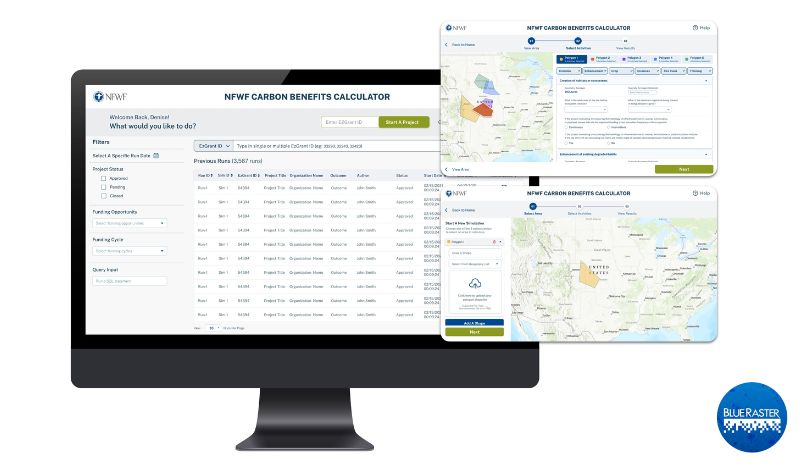
Most of our daily activities create greenhouse gas emissions which exacerbate climate change. Organizations like the National Fish and Wildlife Foundation (NFWF) spearhead efforts to mitigate these negative impacts by funding initiatives that offset emissions and create a greener earth. Blue Raster partnered with NFWF to create a robust Carbon Benefits Calculator. This tool estimates and visualizes the carbon impact of past and planned conservation efforts, restoration, and improved land management activities of NFWF.

NFWF Carbon Benefits Tool

NFWF wanted to innovate and optimize their existing in-house carbon calculator tool that was hosted in Excel. Blue Raster understands the need for a spatially explicit, robust tool that provides real-time calculations and eliminates hard-coded values to improve usability and usefulness. Additionally, this new tool enables NFWF to assess activities in various locations over different time series quickly and easily.

Our team created a web application backed by geoprocessing services in Python scripts. The tool allows a user to upload a spatial polygon for an area of interest to calculate carbon benefits, expanding the previous functionality that only allowed analysis at the county level. These calculations are done with python logic and geoprocessing services that are uploaded to ArcGIS Enterprise. Converting the tool from a spreadsheet-based calculator to a real-time and streamlined web application allowed for faster, easier, and more comparable results.

This tool uses various raster datasets including national land cover and carbon stocks to calculate the different properties and values such as climate, location, size, carbon stock, and land cover of the user submitted area of interest. Then, the tool automatically takes those values from the raster data and calculates the carbon benefits that would result from the selected project. NFWF can use this tool to estimate the carbon benefits of various projects and events such as invasive species clearing, crop and livestock use, thinning, fires, land transformations, over a 30-year period.

Previously, Blue Raster built out the Where We Work web map for NFWF to help illustrate the extensive geographic reach of their mission and impact of their conservation programs. Also, we built a proposal reviewer application and aided in NFWF's ArcGIS Enterprise installation.

We are excited to continue our collaborative efforts and work with a long-time partner by supporting NFWF with the Carbon Benefits Calculator and ongoing conservation efforts.

Ready to find out more?

We are excited to be a part of another non-profit's ongoing conservation and restoration efforts! Contact us today to learn how we can help your organization.

Non_Profit

Celebrating ArcGIS Enterprise Implementation with Blue Raster’s Scott Geistmann

ArcGIS Enterprise is a perfect fit for deployment to a cloud platform enabling mapping and visualization, analytics, and data management. It is the foundational tool in an organization’s suite of Esri applications such as ArcGIS Pro and distributed collaborations with ArcGIS Online. Blue Raster assists its customers with Enterprise implementations in order to expand their spatial data analysis and data storage capabilities while unlocking new, more efficient workflows utilizing cloud native technologies. Having an Esri Enterprise System Design Professional on our team provides our clients with confidence and peace of mind.

ArcGIS Enterprise System Design Professional

Blue Raster is proud to celebrate our own Scott Geistmann for achieving the Esri Enterprise System Design Professional (ESDP2201) Certification. He is one of fewer than 40 experts who achieved the most recent Esri certification in the ArcGIS Enterprise system design. The certification exam covers 4 primary skill areas – Physical Architecture, Solution Architecture, Deployment and Troubleshooting, and Architectural Concepts. In order to acquire this expert-level certification, Scott mastered the four core skill areas above as well System Design, ArcGIS Monitor, System Log Parser, and eGDB Health tools. Attaining this certification is no easy feat. We applaud Scott for his hard work in ascertaining the content of hundreds of training modules and building countless simulated test environments to apply key concepts in preparation of the certification exam.

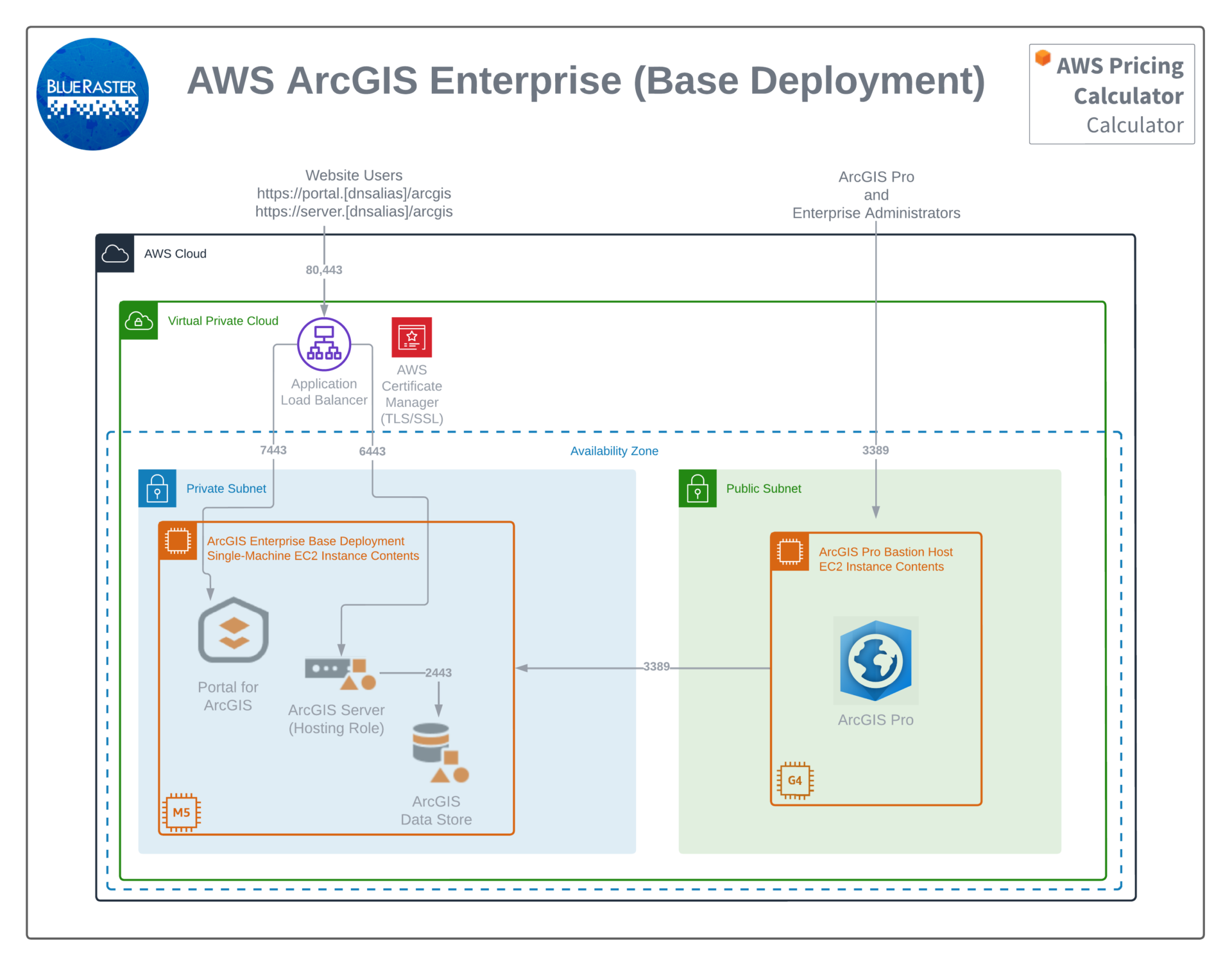
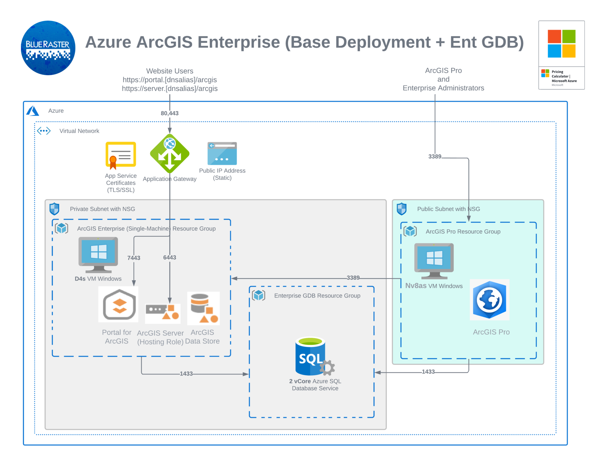
With the proliferation of cloud-based infrastructure over this most recent era of computing, Scott has taken the ball and ran with it. As Blue Raster’s resident enterprise implementation and server architecture expert, Scott provides key expertise to our customers. Scott assists customers by evaluating their current systems, weighing considerations of which upgrades to make, and mapping how to best design each customer’s system according to their unique needs. He has designed proprietary methodologies governing his approach to structuring and implementing customer systems in AWS, Microsoft Azure, and Google Cloud which can be seen in the graphics below. This approach has proved invaluable in implementing more automated processes and standardization in customer systems.

AWS ArcGIS Enterprise Implementation
Azure ArcGIS Enterprise Implementation

Being in the Esri ecosystem since ArcGIS version 9.3, Scott has seen and experienced the full evolution of ArcGIS version 10 and is now looking forward to working with ArcGIS version 11 which is slated to release in 2022.

Scott

Scott’s certification as an Enterprise System Design Professional is part of Blue Raster’s pursuit of Esri's ArcGIS Cloud Specialty Program. This program certifies service providers in system architecture design, managed services, and ArcGIS Enterprise solutions in order to guide customers in their implementations of Esri’s Geospatial Cloud. Three Esri Cloud certifications are required under the scope of the Cloud Specialty Program – the Enterprise Geodata Management Professional, Enterprise Administration Professional, and Enterprise System Design Professional. Blue Raster team members, in addition to Scott, are currently working in preparation for these certifications by following individualized Esri training courses. We at Blue Raster look forward to joining this specialty and sharing our expertise and best practices with our customers.


Page 2 of 3