ArcGIS Hub

Asian American Pacific Islander Community Hub

The Asian American Unity Coalition (AAUC) is an organization that provides a framework for over 70 different Asian American and Pacific Islander (AAPI) organizations to work together to connect, coordinate, and collaborate. To help empower and connect its members, AAUC set out to create a single ArcGIS Hub Site to share critical information and events, provide networking opportunities for AAPI organizations and individuals, and tell the story of the community’s diverse culture and heritage.

AAPI Community Hub

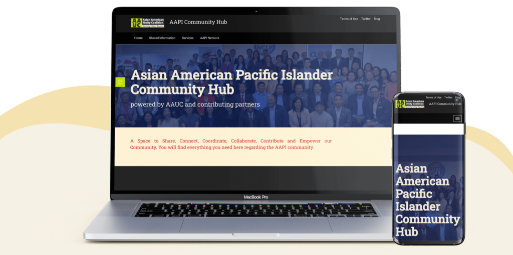
Blue Raster worked with AAUC to design, set-up, and deploy the AAPI ArcGIS Hub pilot prototype to bring together data about organization locations, resources, events, and initiatives. The resulting Asian American Pacific Islander Hub includes Blue Raster designed maps and data functionality in an easily consumable fashion.

Maps in the AAPI Hub

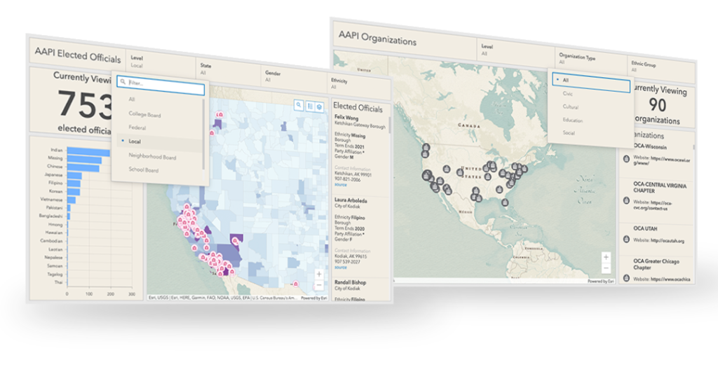
Visualizations include a map showing the locations of AAPI organizations nationwide. Users can click on any organization’s pin on the map to get details and a link to that group’s website. Another map shows the AAPI population by voting district to illustrate the ethnic make up of areas to aid in political advocacy activities. The Hub also includes other features like stories of community heritage that are offered in both native and English languages. The AAPI Community Hub is a powerful tool for AAUC and the AAPI community to share, connect, coordinate, collaborate, contribute and empower the community.


Innovation 2.0: Draper Innovation Index launches new version

Following up on the previous versions of the Draper Innovation Index (DII), Blue Raster is proud to announce the launch of the Draper Innovation Index Global 2.0. According the the Draper Hero Institute (DHI) the ArcGIS Hub site “will be the first index of its kind to be updated monthly to reflect the most current state of the ever-evolving state of economic opportunities, economic freedom for innovators, entrepreneurs, and investors around the globe.”

A collaboration between DHI and Blue Raster, the Draper Innovation Index consists of ArcGIS Dashboards, StoryMaps and Hub.

What is new in this Draper Hero Institute update:

  • The DII Global’s Government Quality category now incorporates the Economist Intelligence Unit’s Democracy Index, which evaluates nations based on five indicator categories: electoral processes and pluralism, government functioning, political participation, political culture and civil liberties. First published in 2006, the Democracy Index draws on survey questions and expert analysis and is updated quarterly. It classifies nations into four categories: full democracies, flawed democracies, hybrid regimes, and authoritarian regimes.
  • The DII’s new Country Sentiment Index, a proprietary DII algorithm, incorporates three main components:
  • S&P Dow Jones’ Global Equity Indices, which measures changes in equity markets, in a specific country or region;
  • Currency fluctuations in relation to the price of Bitcoin;
  • The World Uncertainty Index (WUI), created by International Monetary Fund and Stanford University economists in 2018 as “the first effort to construct a panel index of uncertainty for a large set of developed and developing countries.”

Tim DraperThese additions enable the DII Global to better accomplish its core mission, providing a global look at which countries and regions have the freest economies and the best, most supportive environments for innovation, entrepreneurship, and investment,” said DHI Founder Tim Draper. “This knowledge is more important now than ever, as the competition for employers, skilled workforce, and capital has only become fiercer since governments now need to compete globally for innovators.

Make sure to revisit the DII Global each month to see how rankings continue to shift based on the most current data.

Tracking Trends of Innovation and Entrepreneurship with The Draper Innovation Index

Draper Hero Institute, Esri and Blue Raster team up to launch the Draper Innovation Index

Founded by legendary Silicon Valley venture capitalist and entrepreneur Timothy C. Draper, Draper Hero Institute (DHI) provides applicable and modern resources for future entrepreneurs globally and ensures inclusiveness and opportunities for all.

A key example of one of those modern resources is the recently launched Draper Innovation Index.

The Draper Innovation Index is a Hub for ArcGIS site that contains several ArcGIS Dashboards and a StoryMap that displays key success factors, metrics, and indicators that support the performance of local startups and facilitate the creation of new jobs and economic prosperity, such as employment creation, VC funding, startup culture, tax regulations, and IP creation. Additionally, it provides innovation data from an entrepreneurial/VC perspective as opposed to others that exist from an academic point of view.

Draper Innovation Index

When Esri looked for a partner to take over the project after they had built the initial Hub, Dashboards and StoryMaps collection of tools called the Draper Innovation Index – they tapped longtime collaborators and Esri Gold Partner Blue Raster on the shoulder.

The Draper Innovation Index (DII) was initiated by Draper Hero Institute as an index consisting of a series of data indicators on the state of entrepreneurial activity, environment, and drivers – nationally and globally. Under the leadership of Program Manager Phil Satlof ; GIS Analyst Mary Bracho and Visual Designer Manny Fleurival adapted and enhanced the Hub and tools and participated in the global launch event on March 25th, which was covered by the Wall Street Journal.


With our goals to create a global index to foster the development of innovative technology and economic growth, Blue Raster and their team seamlessly achieved our vision. They transformed the complex data metrics and analysis into a user-friendly, visually aesthetic interactive tool. With the successful launch of our global index, we are excited to share this leading-edge tool with the world.” — Vivian Lufkin Executive Director, Draper Hero Institute”

We are now preparing for the launch of the USA Index on May 27th! Check index.draperhero.org for more news.

Draper Innovation Index

City of Lynnwood ArcGIS Hub Support


Lynnwood Hub

Blue Raster recently worked with the City of Lynnwood, Washington to support their Connect Lynnwood ArcGIS Hub launch. Our team assisted in the design and creation of the Connect Lynnwood Hub Site and their 10 Minute Walk (10MW) Initiative. Part of the Esri Geospatial Cloud, ArcGIS Hub provides a two-way engagement platform to connect government and citizens. The Pew Research Center found that “65 percent of Americans search online for information about their government. Yet, less than 10 percent report finding what they need.” Through ArcGIS Hub, local officials like those at the City of Lynnwood are able to easily publish data and story maps to allow their citizens to get more involved with their community.

Lynnwood Hub mobile


Connect Lynnwood Splash Page

Using an ArcGIS Hub Site, our team designed a custom splash page to serve as a home-base for Connect Lynnwood. The page features Lynnwood initiatives, events, open data, and other information about the city. An open data search allows community members to enter keywords or phrases to get content results instantly. The splash page also includes multiple featured maps covering a variety of topics including general history, major projects  and more! The page also features Lynnwood’s Initiatives, such as the 10 Minute Walk Campaign. Lastly, an events calendar enables Lynnwood to create, manage, and share events to inform community members of upcoming opportunities for involvement. When clicking on an event, users can RSVP and also easily share the event with other community members via Facebook or Twitter. The Lynnwood event manager can also stay connected with RSVP’ed attendees by sending  updates and sharing information that might interest them.


Initiative Page

The City of Lynnwood launched their 10 Minute Walk Campaign as their first ArcGIS Hub Initiative. On the Initiative page, community members can learn about the campaign and sign up to become “park walk champions.” As park walk champions, community members record their walks around the city’s numerous parks, and complete surveys that will be used by the City of Lynnwood to assess park and green-space accessibility. By leveraging ArcGIS Hub, the city is able to easily and effectively two-way engage with its citizens.

Check out the City of Lynnwood’s ArcGIS Hub here! Then, learn more about Blue Raster’s ArcGIS Hub Accelerate offerings!

Page 2 of 2