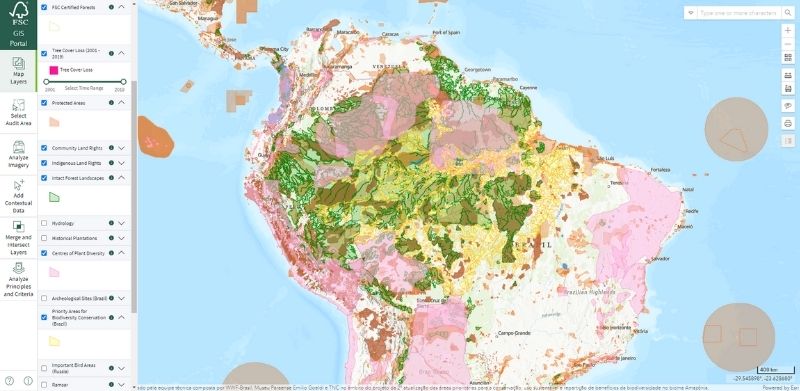
Blue Raster is proud to have developed and supported an audit area tool for the Forest Stewardship Council (FSC). This solution pulls data so that auditors can examine historic and current tree cover before going on site to complete their inspections. Now it’s available with high resolution imagery!
Blue Raster recently integrated high resolution satellite imagery from Planet and Sentinel into the audit area tool. This new imagery, made available by Norway’s International Climate & Forests Initiative, provides 3-meter resolution as compared to the pre-existing 10-meter resolution type used in the tool. This new level of detail in images provides an even clearer picture of forestry practices and realities.
In addition to the new imagery, the team also updated and reorganized the layer panel to make the maps more user friendly. New tools that measure elevation changes were also added.
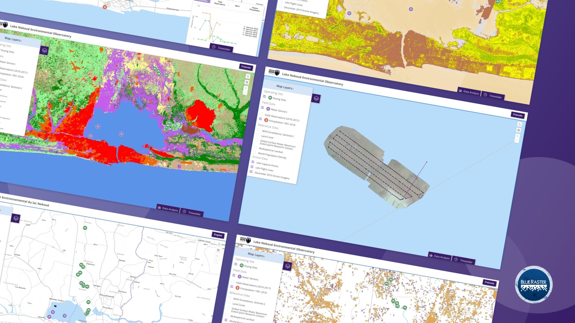
The water hyacinth is an invasive aquatic plant found in Lake Nokoué in the southern area of Benin. This plant grows rapidly, forming thick layers on the water, shading out other plants. As it decays, it depletes oxygen levels, impacting the fish and other aquatic life in the lake. In addition to the ecological impacts, the hyacinth also has economic impacts, clogging up transportation routes. The hyacinth fiber has a high-performance absorption power for all types of liquids, from dyes to crude oil and heavy fuel oil. Green Keeper Africa created a transformation path that takes harvested hyacinths and converts them into an absorptive product that can soak up oil spills.
Building an Economic Engine
In order to produce the absorption solutions, Green Keeper Africa works with local communities to collect and prepare the hyacinth for production. The company needed more visibility into the growth patterns to be able to set pricing each season and direct harvesters to the most abundant areas.
Blue Raster developed an application that uses an algorithm to detect water hyacinth in satellite imagery. The application also gathers data from water sensors currently being prototyped by MIT as well as other ground data and water quality readings. Green Keeper uses this view of real time and historic data to fairly set prices and plan for harvest areas they need to support.
Beyond Hyacinth Tracking
This application can help promote additional sustainable and profitable uses of Lake Nokoué. Acadja is a fishing method where dense masses of branches are set in an area to attract fish in large numbers for harvesting. The Blue Raster application can use footage from drones to map the placement of the Acadjas, overlaying that information with other data to track environmental impacts and/or present alternate locations or methods that may result in more fish with less environmental impact.
Contact us to learn more about how Blue Raster can customize applications for you!
Manassas Park is an independent jurisdiction in Northern Virginia, approximately 30 miles southwest of Washington, DC. The city borders Prince William County and the City of Manassas. It is primarily residential in nature within close proximity to interstate and railway transportation into the heart of the Greater Metropolitan Washington DC area. modernize IT
The city had an aging, homegrown solution for their GIS data and wanted to modernize the system so that it would meet the current and future needs of City operations including tax assessment, public works, emergency response, parks and recreation, and zoning to name a few. Being a small city with an even smaller staff, the system needed to be easy to use and maintain for a team that did not include GIS professionals.
Creating a Town Square for Data
Blue Raster implemented Esri tools, including ArcGIS Online, Experience Builder, and ArcGIS Dashboards, to aggregate all data into a single cloud-enabled solution. Doing so meant users across city operations had access to data that could inform them of their planning and day-to-day operations.
Economic Dashboards show tax assessment growth over time as well as show revenue generated from meals tax and business licensees by neighborhood.
The parks department now has a single view into their multiple data sources. They can now access and view membership for the city-run waterpark, visitor numbers for that waterpark, and community center reservations in a single application.
The police can now overlay data from multiple ticketing systems (parking, civil disturbance, and traffic) to get a holistic view of where violations are happening.
Fire and rescue can now see 911 data to get a sense of any patterns in where and when calls come in.
First Step Toward Cloud
The city manager is using this GIS project as a pilot to show what can be done when the City utilizes the power of cloud technology. Pointing to the success of these applications, he hopes to gain buy in and funding for modernizing other areas of the City’s IT infrastructure to a cloud-based system.
Read the Esri case study about the use of ArcGIS Velocity in Manassas Park:
Contact us to learn how we can help you modernize your data and IT infrastructure to help make critical decisions about public safety, recreation, economic investments, and more. Read about we helped other state, county, and city organizations with their efforts to modernize IT.
Blue Raster is a proud member of the Esri Nonprofit Specialty. Partners receive this Nonprofit Specialty designation for their alignment with and their knowledge and expertise of Esri’s Nonprofit Organization Program. Additionally, we demonstrate experience with projects in many nonprofit industries: conservation, humanitarian, disaster response, food security, community development, racial equity and social justice, health research, and more.
The Esri Nonprofit Program provides nonprofit organizations low cost licenses and access to a Esri's vast offerings of location intelligence tools and training. We are proud to support a wide variety of nonprofit clients in using these location intelligence tools to help inform decisions and shape programs that meet the needs of their constituents. Receiving the Esri Nonprofit Specialty designation is an exciting next step in furthering our mission to help nonprofit and NGO clients achieve their goals.
Nonprofit Experience
Blue Raster has deep expertise developing platforms for managing and disseminating geospatial data and analysis to support conservation efforts with the Esri ArcGIS platform. Since our founding in 2002, we've had the honor of working with over 70 nonprofits and NGOs. For example, we work with leading nonprofit conservation organizations including the World Resources Institute, the Jane Goodall Institute, The Nature Conservancy, World Wildlife Fund, Wildlife Conservation Society, NatureServe, National Audubon Society, Stimson Center, and more.
Blue Raster continues its commitment to bringing the latest in geospatial technologies to leading conservation, global development, humanitarian & disaster response, social justice, and health research & advocacy organizations.
“We look forward to expanding our work in the nonprofit sector as part of this Esri specialty,” commented Michael Lippmann, Principal/Founder of Blue Raster. “Our team thrives on helping organizations make connections between data to better communicate and power their impact.”
Are you a nonprofit looking to better utilize your data?
Contact us today to learn more about the Esri Nonprofit Organization Program!
The Forest Stewardship Council (FSC) is an association committed to promoting environmentally appropriate, socially beneficial, and economically viable management of the world’s forests. Using 10 guiding principles, FSC is the gold standard for certifying responsible forestry practices.
Many of the principles and criteria measured by FSC are assessed by satellite imagery. However, much of the work was still happening with pen and paper on printed maps. FSC wanted to combine this imagery with other data to aid in pre-audit evaluations to streamline and standardize the work that has to be done in the field. This would provide auditors with preparation and additional context for what they see in person.
Using the Blue Raster developed solution, auditors can select an their Audit Area from FSC's dataset of certified forest boundaries, upload a boundary file they have received, or draw a polygon directly on the map. The auditor also begins a digital workflow that details what aspects of the forest are being examined, what data will be used, and what reports and statistics need to be created.
Annual tree cover loss data from the University of Maryland is automatically pulled and overlaid on the image,allowing auditors to toggle between time periods to see if the change is in line with FSC principles. Users can also perform a basic change detection by selecting before and after images, calculating a vegetation index on both, and comparing the results to identify areas with loss or gain in vegetation. Reports are automatically populated for viewing on a dashboard or for printing.
The use of the solution expanded when the COVID pandemic limited travel and allowed auditors to continue evaluating areas remotely, creating temporary reports until they could physically get to the location. FSC is looking at ways to expand the functionality beyond auditor preparation. This system could be used to document chain of custody and detect fraud in the audit system by confirming that the harvested amount reported could have been harvested from a single location, ensuring that totals are not being laundered.
This GIS Portal is another great tool that helps the forest industry meet our current needs for forest products without compromising the health of the world’s forests for future generations.