Blue Raster helps you tell your story through interactive
mapping technology. Make your message clear, exciting,
and user-friendly for both mobile and web platforms.
On Friday April 19th the White House announced the launch of Conservation.gov, an information hub supporting locally led efforts to conserve and restore our nation’s lands, waters, and wildlife. Designing this brand new website was an exciting project that Blue Raster was proud to support. Launched just in time for Earth Day 2024, Conservation.gov is home to a wide variety of resources that support conservation, including the American Conservation and Stewardship Atlas (currently a beta version).
Conservation.gov Welcome Banner
To celebrate and announce the launch of Conservation.gov the White House released a press statement, including a quote from John Podesta, Senior Advisor to the President for International Climate Policy, who said:
“With the launch of Conservation.gov and its tools like the American Conservation and Stewardship Atlas, Americans can explore how they can take action to support conservation in their own communities.”
Conservation.gov Interactive Map
Blue Raster supported this project by designing the website and pages using ArcGIS Hub. Blue Raster provided the visual designs, page layouts and graphic elements for the site, as well as configuring some of the included interactive elements such as the Find Financial Assistance tool. In supporting this project Blue Raster worked closely with our Esri partners, and an interagency partnership co-led by the Department of the Interior (DOI), United States Department of Agriculture (USDA), National Oceanic and Atmospheric Administration (NOAA), and Council on Environmental Quality (CEQ).
This prototype tool currently aggregates financial assistance information from select programs in Grants.gov
Inspired by our work on Conservation.gov? Contact us to discover how Blue Raster can tailor GIS solutions to enhance your organization's impact.
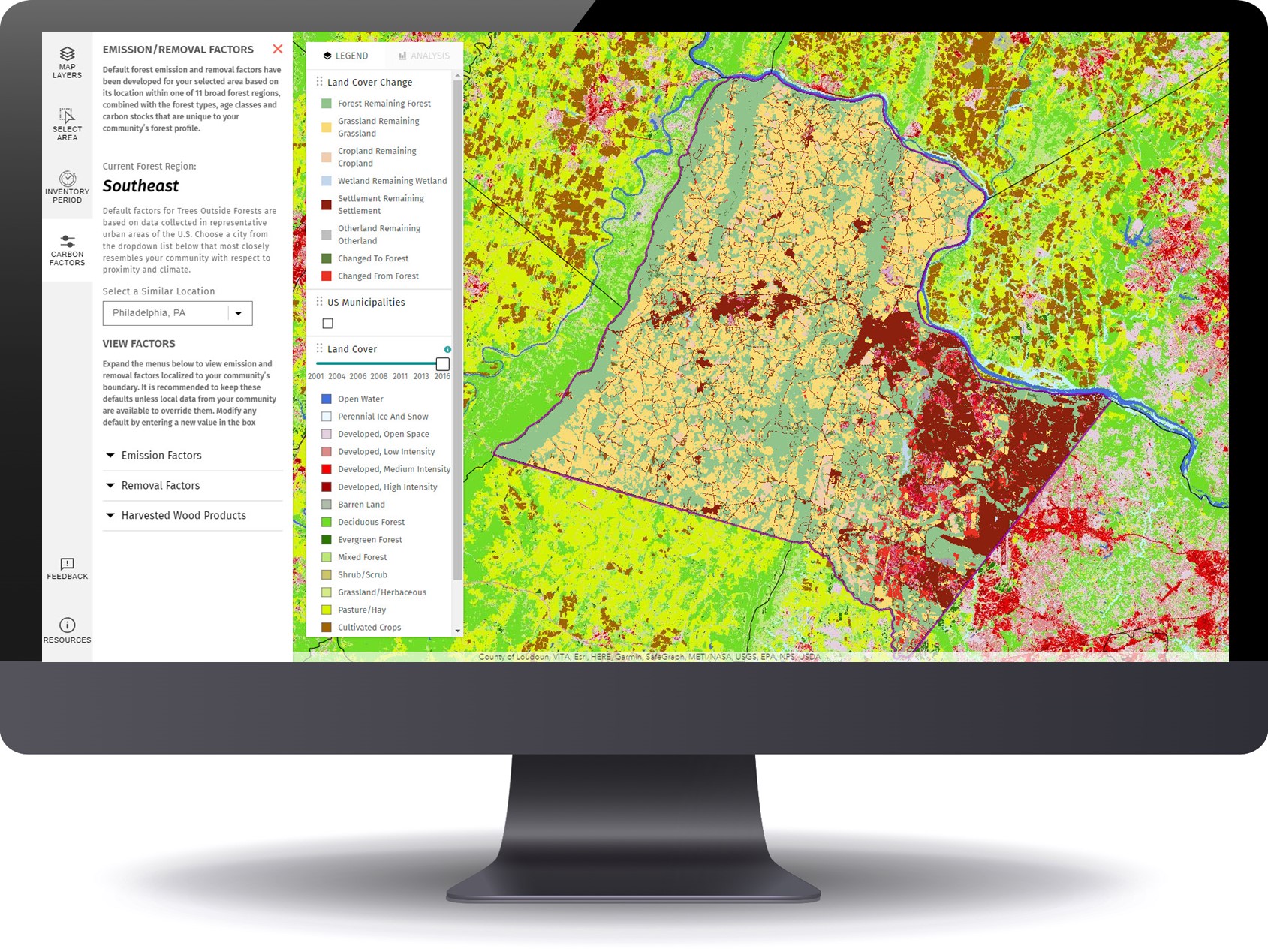
Many organizations prioritize the accessibility of imagery and image-derived products for visualization and analysis among both internal and external users. As such, efficient management and delivery workflows are crucial for these organizations to fully harness the power of spatial data and maximize their product impact. Use cases for aerial images and raster data include land cover classification, urban planning, natural resource management, emergency response and disaster management, precision agriculture and conservation, environmental monitoring and change detection/climate change analysis.
Blue Raster specializes in utilizing the robust capabilities of GIS and cloud services to facilitate the seamless assembly, analysis, management and dissemination of multiresolution imagery, and raster data from different sources and timeframes. Our expertise helps organizations enhance their spatial data management and analysis capabilities.
Employing ArcGIS for Imagery Hosting, Analysis & Management
Empowered by cutting-edge technology, Blue Raster excels in tapping into the full potential of ArcGIS for image hosting, analysis, and delivery workflows across ArcGIS Enterprise, ArcGIS Pro, and ArcGIS Online. With ArcGIS Image Server and ArcGIS Image for ArcGIS Online, we enable organizations to host and conduct dynamic imagery analysis on an unprecedented scale.
The scalability and performance of ArcGIS Image Server redefines the boundaries of what is achievable in geospatial analytics. Additionally, by integrating imagery into the ArcGIS Online platform, organizations can create compelling and informative maps that facilitate a deeper understanding of their spatial data.
Providing On-Demand Imagery Delivery Services
We specialize in providing swift, on-demand collection and smooth delivery of imagery through versatile means including API keys, custom widgets, online user interfaces, and application plugins. Our expertise ensures that you have the necessary tools and support to cater to diverse requirements and preferences.
Whether you need quick access to specific imagery, or a tailored solution embedded within your applications, Blue Raster stands ready to assist, offering a range of flexible and efficient options to meet your unique needs.
Furthermore, we recognize the importance of seamless delivery workflows in ensuring timely access to critical imagery resources. Our solutions are designed to optimize delivery pipelines, minimizing latency and maximizing efficiency. Whether it's delivering imagery to remote field teams or integrating seamlessly with existing systems, we prioritize speed, reliability, and scalability to meet the dynamic needs of our clients.
Our commitment to innovation extends beyond just technology; it's ingrained in our culture. We're constantly exploring new ways to push the boundaries of what's possible, whether it's through advancements in artificial intelligence, cloud computing, or data visualization. By staying at the forefront of technological innovation, we empower our clients to stay ahead of the curve and achieve their objectives with confidence. Our teams of professionals are here to assist you in developing and deploying your delivery workflows.
For over a decade, Blue Raster has been working with clients and partners to deliver large volumes of imagery to support various geospatial workflows. Our cloud specialty has opened new frontiers for collaborative management. Maximizing the cloud's scalability, organizations can now store, share, and analyze vast amounts of data in real-time. This not only streamlines internal processes but also facilitates effortless collaboration with external stakeholders.
Across the globe, our clients and partners are employing our services to manage and deliver their imagery to support their projects and organizational goals. Here are some examples:
Blue Raster is proud to announce another project from our long running collaboration with The Jane Goodall Institute.
Among Jane Goodall's many vital programs is Roots & Shoots, with the mission to empower young people to affect positive change in their communities.
In 2023, JGI collaborated with the John Templeton Foundation to award the Templeton Roots & Shoots Prizes.
From the JGI website: "The Templeton Roots & Shoots Prizes are an extension of the partnership between JGI and the John Templeton Foundation to elevate the extraordinary efforts of visionary youth leaders and their adult mentors worldwide. Awardees were selected based on their exceptional work with Roots & Shoots at the intersection of science, compassion, and community – specifically those who exemplify curiosity and wonder and the pursuit of knowledge, as well as the expression of compassion towards people, other animals and the environment we share."
When Erin Griffin, Director of Partnerships, Jane Goodall Institute-USA sought a novel way to showcase the 30 winners of the inaugural Templeton Roots & Shoots Prizes she turned to trusted partner Blue Raster and the concept of an ArcGIS StoryMap.
The StoryMap showcases the 2023 winners and features an interactive map, videos and a brief write up of each winner and their vital contributions.
Blue Raster built several StoryMaps for The Jane Goodall Institute. The platform is ideal for visual story telling, with or without a map based visualization.
The Delaware River holds a rich tapestry of history, playing a pivotal role in the development of the United States and serving as a witness to centuries of human activity. Flowing for approximately 330 miles through the eastern United States, the river originates in the Catskill Mountains of New York and eventually empties into the Delaware Bay. Its watershed encompasses parts of New York, New Jersey, Pennsylvania, and Delaware, making it a vital waterway that has shaped the region's cultural, economic, and environmental landscape.
It serves as a source of drinking water, supports diverse ecosystems, and offers recreational opportunities. Efforts to balance conservation and development persist, as communities work together to ensure the sustainable use and preservation of this historic and ecologically significant waterway. Today, the Delaware River continues to play a crucial role in the lives of millions of people. The Delaware River stands as a symbol of the intertwined relationship between human societies and the natural environment, showcasing the ongoing importance of responsible stewardship for future generations.
Telling the Story of the Delaware River Watershed
Blue Raster partnered with Delaware Currents to create and deliver an educational video about the Delaware river watershed. With aerial footage provided by Light Hawk and contributions from Delaware River Basin Commission (DRBC) and Partnership for the Delaware Estuary (PDE), viewers can embark on an immersive journey along the Delaware River learning about its history, challenges and significance.
Embarking on a flight along the Delaware River unveils a captivating journey through time, weaving together the threads of history, culture, and environmental significance that have shaped this iconic waterway and its expansive watershed. This aerial expedition provides a unique perspective, allowing us to appreciate the interconnectedness of the region's past, present, and future.
As we approach the 20th century, the flight takes us over urban centers and industrial landscapes, bearing witness to the environmental challenges that emerged. Efforts to balance industrial progress with environmental preservation became increasingly critical, leading to the establishment of regulatory bodies like the Delaware River Basin Commission. This commitment to conservation aimed to protect the river's waters and ecosystems for future generations.
The journey concludes as we survey the modern landscape shaped by environmental stewardship and community engagement. The Delaware River stands as a testament to the resilience of ecosystems, the importance of clean water, and the ongoing efforts to balance human needs with environmental sustainability. From the headwaters to the estuary, the flight along the Delaware River highlights not just a waterway but a living, breathing testament to the intertwined history, culture, and ecology of the region—a journey through our history, our watershed.
The Impact of Partnerships in Storytelling
The creation of the video involved a collaborative effort, bringing together various organizations, contributors, and media partners to produce a visually stunning and informative exploration of the Delaware River. Brought to you by Delaware Currents, the video's production was made possible through the support of key entities and contributors. The Blue Raster team was responsible for editing and production of the video, incorporating GIS element to provide a more spatial context and location-based visualizations. Of particular note, the DRBC played a pivotal role in providing insights into the river's management, regulatory efforts, and environmental conservation while the Partnership for the Delaware Estuary added valuable insights into the ecological importance of the river's estuarine region and its role in sustaining diverse ecosystems. Media partners played a crucial role in amplifying the project's reach, ensuring that the video's content was well researched and reached the necessary audiences through various platforms.
Freshwater ecosystems contain an incredible 10% of the world’s known species and support the livelihoods of billions of people including many Indigenous Peoples and local communities. However, since 1970, freshwater plants and animals have declined by 84% due to threats like poor fisheries management, watershed degradation and overuse. The Nature Conservancy is partnering directly with local communities around the world to apply traditional knowledge and co-create new, science-based conservation strategies.
To tell the story of its partnership with these Indigenous People and Local Communities, The Nature Conservancy employed the services of long-time partner, Blue Raster to develop a series of Storymaps to shed light on TNC Freshwater Community-Led Conservation Program’s work with freshwater communities and indigenous people, highlighting their efforts to propagate and enhance community-led conservation initiatives across Africa and Latin America.
TNC's collaboration with communities in Africa is focused on three critical regions: the Bas Ogooué wetland area in Gabon, the upper catchment of the Okavango Basin in Angola, and the remarkable Lake Tanganyika, which borders Tanzania, Zambia, the Democratic Republic of the Congo, and Burundi. In Latin America, TNC's collaboration with communities extends to the Andean Amazon region in Ecuador, Colombia, and the Tapajos River Basin in Brazil. These ecosystems are not only home to remarkable biodiversity but also provide essential resources and cultural heritage for indigenous peoples. By partnering with local communities, TNC aims to strengthen their capacity to manage and protect their ancestral lands sustainably.
Blue Raster's expertise in utilizing ArcGIS StoryMaps has allowed TNC's conservation efforts to be communicated effectively, enabling users to engage deeply with the stories being shared. By combining rich media, interactive maps, and engaging narratives, the StoryMaps create a powerful medium for storytelling. The StoryMaps developed by Blue Raster incorporate compelling graphics, audio soundscapes, maps developed and published in ArcGIS Online and high-resolution images, capturing the essence of the fisheries, landscapes, communities, and wildlife that TNC works tirelessly to protect. These visuals not only enhance the aesthetic appeal but also serve as a means to evoke emotions and foster a sense of connection with the featured regions. Developed in English, the StoryMaps created are also available in African French, Latin American Spanish, and Brazilian Portuguese translations.
These maps not only offer a geospatial perspective of TNC's work but also provide users with an opportunity to explore the geographical context and understand the intricate relationships between freshwater habitats and communities. Through the interactive maps, readers can visualize the conservation initiatives, the areas of focus, and the significance of indigenous and local community participation. By utilizing ArcGIS StoryMaps as a powerful storytelling tool, TNC can effectively communicate its vision for the future, emphasizing the importance of continued partnerships and collaborative efforts with indigenous people and local communities. The immersive nature of the StoryMaps helps stakeholders envision a future where freshwater ecosystems thrive, and IPLCs actively contribute to their protection.
The collaboration between Blue Raster and The Nature Conservancy is a testament to the power of technology and partnerships in conservation efforts. Through the creation of immersive StoryMaps, TNC's work with freshwater communities and indigenous people in Africa and Latin America is brought to life. By amplifying these stories in local languages, Blue Raster and TNC empower communities to take an active role in preserving their natural heritage and build a future where people and nature thrive in harmony. Together, they are forging a path towards a more sustainable and equitable world.
“The Freshwater Community-Led Conservation Program is excited about our story map, made in partnership with Blue Raster. We hope those who engage will learn about the important efforts of the local communities, partners and TNC staff in freshwater fisheries and biodiversity conservation and feel invited to participate. The story map platform both allowed us to tell the efforts of our program as a cohesive unit across our work in Latin America and Africa and allowed us to highlight the unique impacts specific to local communities and partners.”
- Allison Aldous, Director of the Freshwater Community-Led Conservation Program
 Conservation.gov Welcome Banner
 Conservation.gov Interactive Map
 This prototype tool currently aggregates financial assistance information from select programs in Grants.gov
 Providing On-Demand Imagery Delivery Services