Esri

New Era for Plant Mapping at New York Botanical Garden with PlantTracker

New York Botanical Gardens Plant Tracker App displayed in a laptop and iPhone.

Established in 1891 and covering 250 acres in the Bronx, New York Botanical Garden is the largest urban public garden in the United States. With the beauty of the collections, landscapes, and gardens it's no wonder why over one million people visit the garden annually. Looking to upgrade their public mapping presence and expand internal use of GIS, NYBG and Blue Raster partnered to develop PlantTracker. Replacing a previous tool, PlantTracker is the online catalog of NYBG's living collections used to find plants, navigate the grounds, get plant information, view photographs, and take curated tours. 

NYBG Plant Tracker App displayed on an iPhone

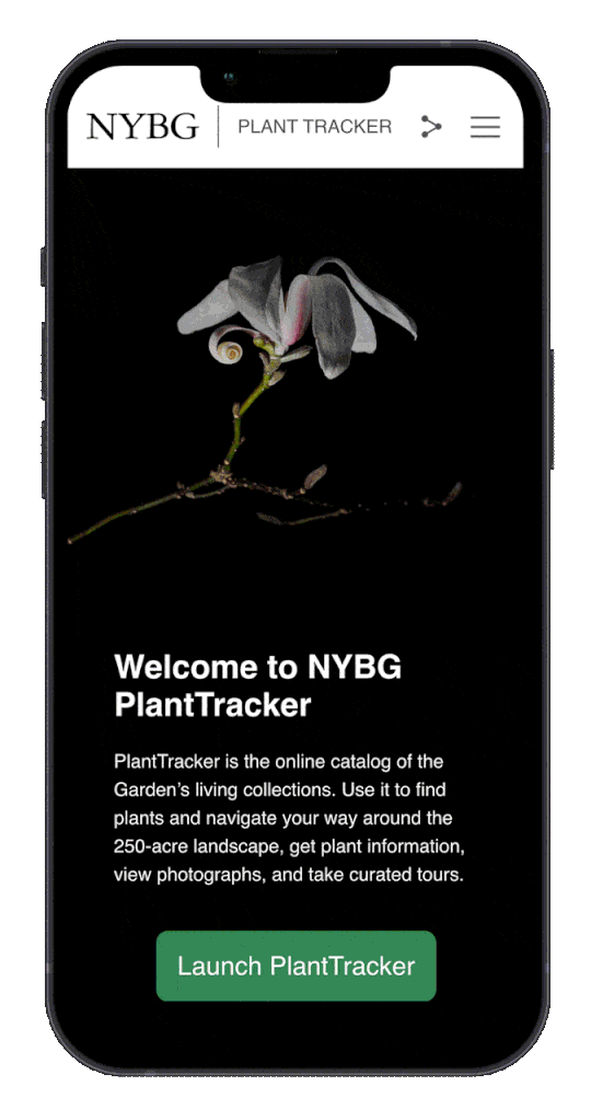
PlantTracker aides the public onsite and from home and also daily workflows of NYBG staff and the institutions educational programs rely on the tool. Funded through an IMLS Grant, PlantTracker replaces the legacy Garden Navigator application and provides an enhanced user experience with a map-centric and mobile-first design.

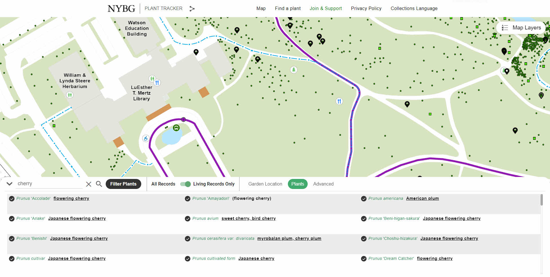
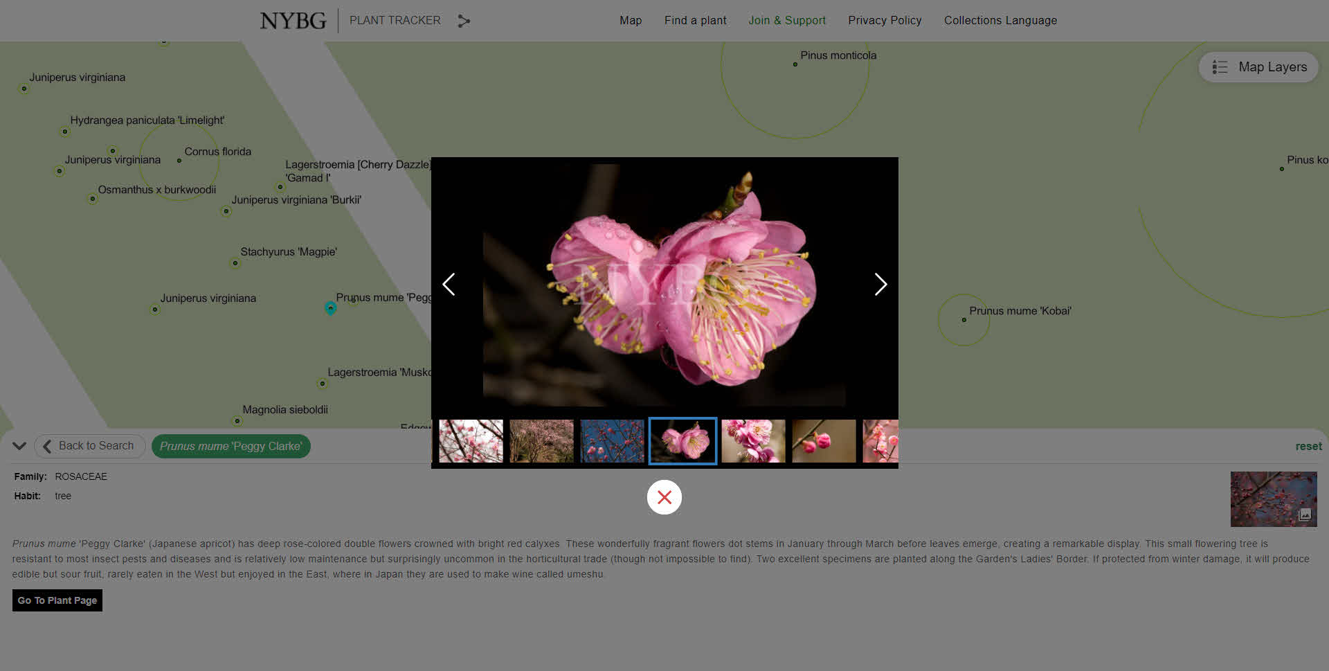
Blue Raster first deigned a GIS architecture environment and installed and configured ArcGIS Enterprise. Next, Blue Raster had to create many spatial datasets for use in GIS by converting existing CAD files and tables. This included working with exports of plants managed through BG-Base, totaling over 143,000 living and historical records. The GIS Team at Blue Raster improved the spatial accuracy of almost 700 location codes used for mapping and outlining the main garden locations. Plant photo workflows were also upgraded by integrating with the Asset Bank API.

In addition to PlantTracker, GIS upgrades allowed the opportunity to integrate Esri mobile workflows for staff. Configuration with ArcGIS Field Maps and Workforce for ArcGIS expands plant mapping workflows, allowing workers to update existing location, condition and measurement data in the field. Blue Raster works closely with BG-Base to sync both systems through a series of Python scripts that run nightly and as often as every five minutes. This means NYBG can continue to use BG-Base as the system-of-record for their collections, but take full advantage of GIS for mapping applications and field workflows.

NYBG has embraced GIS in a big way. In short time, a lot has been done to improve public and staff workflows around mapping. Explore NYBG PlantTracker to see for yourself!

NYBG Tour
NYBG Gallery
NYBG Details
planttracker

Learn more about Blue Raster's work with public gardens, cemeteries, and arboretums here.

Contact us today!

Driving Forward with VDOT’s Integrated Directional Signing Program

While driving on the highway you likely find yourself looking at signs lining the road to determine your next meal, gas stop, or a place to stay. You probably do not consider that there is a directional signing program that manages the accuracy of these signs, but you trust the information and services they provide. 

In Virginia, Blue Raster partnered with Directional Signing Program (DSP) to put in place Esri workflows that help ensure you can trust these signs. Using ArcGIS Online, Field Maps, Survey123, Workforce, and Dashboards, the signing program at VDOT has never been more interactive and in real-time. The Integrated Directional Signing Program (IDSP) includes over 16,000 signs across the State and is comprised of:

  • Logo Guide Signs - Blue highway signs with gas, food and lodging company logos
  • Tourist-Oriented Directional Signs - Blue highways signs with directional information, no company logos
  • Supplemental Guide Signs - Cultural, recreational, education and historic guide signs
  • General Motorist Service Signs - Generic symbols representing Gas, Food, Lodging, Hospitals and Camping
  • Historic Markers - Signs depicting historic information about places, people or events

directional sign

Blue Raster's workflows for field GIS allow DSP and other VDOT contractors to inventory and update the status of every sign in the IDSP. The initial inventory of all 16,000 signs was completed in just 5 weeks with the help of Field Maps and offline capabilities. Since then, routine inspections for condition and retroreflectivity, construction inspections, or maintenance work orders for signs has been managed in GIS with Esri's field applications. Data from the field crews feed a series of dashboards configured to show key metrics and status to VDOT in real-time.

Beyond just VDOT, the IDSP is made up of the customers on the signs and the public. Through hosted web maps and Survey123 forms, there is now the ability for both customers and the public to view an interactive map of all the signs in the IDSP (with current image), provide general feedback on the program, and report sign issues or knockdowns.

directional signing program

Integrating ArcGIS into the IDSP allows for significant improvements to data collection, understanding of assets, efficiency, reporting and tracking goals. Continued work with DSP and VDOT includes developing StoryMaps around the Historic Marker Program, leveraging Business Analyst to attract new customers and understand interchange saturation and vacancies, and better use of imagery including 360 degree capture. All of this work makes the IDSP better, and provides a better experience to drivers in Virginia.

Esri State and Local Specialty:
Enabling Digital Communities Nationwide

Blue Raster is proud to be a Partner in the Esri State and Local Specialty program. The State & Local Government Specialty program is designed to help Esri customers identify providers with ArcGIS expertise and substantial experience in working with local, state, county, and city governments. Partner companies must demonstrate a track record of delivering value to these organizations.

State and Local Experience

Blue Raster supports the development of platforms and applications that help state and local organizations manage, use, and disseminate geospatial data and analysis to for better decision making regarding policy, budgets, planning, and more. Using the full Esri platform, we provide a full range of services setting up ArcGIS Enterprise, ArcGIS Hub site, and Operations  Dashboards to optimizing Field GIS tools like Field Maps, Survey 123, ArcGIS Workforce, and ArcGIS Collector. Our state and local support has spanned the nation from coast to coast including small towns, to major metropolitan areas.
Our solutions, leveraging all aspects of the ArcGIS platform have supported:

  • Emergency Response
  • Fire Services
  • Law Enforcement
  • Fish & Wildlife
  • Planning & Development
  • Transportation
  • COVID Response
Blue Raster - State and Local Government Specialty

Blue Raster solutions and services are available to state and local agencies via the GSA schedule as well as a number of state contracts including Virginia's eProcurement Portal (eVA ID #VS000009118), Maryland CATS+, and Pennsylvania Disaster Emergency Suppliers.

Michael Lippmann
“We’re proud to have our state and local experience and expertise recognized with our place in the specialty program,” said Michael Lippmann Principal/Founder of Blue Raster. “We’re looking forward to expanding out work with communities to ensure data is being used and understood in ways that can make a direct impact on how citizens live, work, and play.”

We’re here to serve any state and local organization looking to better utilize their data
Contact us today to learn more about the Esri State and Local Specialty Program!

State and Local Government Logos

Esri Nonprofit Specialty: Enabling Nonprofits to Use GIS for Greater Impact

Esri Nonprofit Specialty

Blue Raster is a proud member of the Esri Nonprofit Specialty. Partners receive this Nonprofit Specialty designation for their alignment with and their knowledge and expertise of Esri’s Nonprofit Organization Program. Additionally, we demonstrate experience with projects in many nonprofit industries: conservation, humanitarian, disaster response, food security, community development, racial equity and social justice, health research, and more.

Esri Nonprofit Specialty

The Esri Nonprofit Program provides nonprofit organizations low cost licenses and access to a Esri's vast offerings of location intelligence tools and training. We are proud to support a wide variety of nonprofit clients in using these location intelligence tools to help inform decisions and shape programs that meet the needs of their constituents. Receiving the Esri Nonprofit Specialty designation is an exciting next step in furthering our mission to help nonprofit and NGO clients achieve their goals.

Nonprofit Experience

Blue Raster has deep expertise developing platforms for managing and disseminating geospatial data and analysis to support conservation efforts with the Esri ArcGIS platform. Since our founding in 2002, we've had the honor of working with over 70 nonprofits and NGOs. For example, we work with leading nonprofit conservation organizations including the World Resources Institute, the Jane Goodall Institute, The Nature Conservancy, World Wildlife Fund, Wildlife Conservation Society, NatureServe, National Audubon Society, Stimson Center, and more.

Nonprofit logos

Blue Raster continues its commitment to bringing the latest in geospatial technologies to leading conservation, global development, humanitarian & disaster response, social justice, and health research & advocacy organizations.

“We look forward to expanding our work in the nonprofit sector as part of this Esri specialty,” commented Michael Lippmann, Principal/Founder of Blue Raster. “Our team thrives on helping organizations make connections between data to better communicate and power their impact.”

Esri Nonprofit groups

Are you a nonprofit looking to better utilize your data?

Contact us today to learn more about the Esri Nonprofit Organization Program!

Nonprofit Specialty

Explore Innovation and Entrepreneurship in the USA with The Draper Innovation Index U.S.

Following the launch of the Draper Innovation Index (read about it here) in March, Blue Raster is excited to announce the launch of the US focused Draper Innovation Index U.S. (DII U.S.) available at index.draperhero.org.

Built using ArcGIS Hub, ArcGIS Dashboards, and ArcGIS StoryMaps, the DII US includes three major scenarios: Balanced, Tech Innovation Environment and Regulatory and Tax Environment. These scenarios weight six sub-indices, providing a look at state performance in a variety of categories.

Continuing the partnership that launched the global Draper Innovation Index, the Draper Hero Institute, Blue Raster and Esri collaborated on the project.


“The ability to drill-down and understand the Draper Innovation Index at a more granular sub-national level is essential to understanding which states could be a good environment for innovation and economic investment,” said Salim Sawaya, Lead for location intelligence technology provider Esri’s Nonprofit & Global Organizations Team. “Esri and our partner Blue Raster continue to support the Draper Hero Institute find and use authoritative datasets for their US states index so that investors and innovators can leverage the power of location intelligence through GIS to identify the states that hold the most potential or promise.”


About Draper Hero Institute

Founded by legendary Silicon Valley venture capitalist and entrepreneur Timothy C. Draper, Draper Hero Institute (DHI) provides applicable and modern resources for future entrepreneurs globally and ensures inclusiveness and opportunities for all.


Page 6 of 17