Our Work

Blue Raster helps you tell your story through interactive
mapping technology. Make your message clear, exciting,
and user-friendly for both mobile and web platforms.

Development

Blue Raster Pioneering Imagery Management Technology and Delivery Workflows with ArcGIS

Many organizations prioritize the accessibility of imagery and image-derived products for visualization and analysis among both internal and external users. As such, efficient  management and delivery workflows are crucial for these organizations to fully harness the power of spatial data and maximize their product impact. Use cases for aerial images and raster data include land cover classification, urban planning, natural resource management, emergency response and disaster management, precision agriculture and conservation, environmental monitoring and change detection/climate change analysis.

Blue Raster specializes in utilizing the robust capabilities of GIS and cloud services to facilitate the seamless assembly, analysis, management and dissemination of multiresolution imagery, and raster data from different sources and timeframes. Our expertise helps organizations enhance their spatial data management and analysis capabilities.

Employing ArcGIS for Imagery Hosting, Analysis & Management

Empowered by cutting-edge technology, Blue Raster excels in tapping into the full potential of ArcGIS for image hosting, analysis, and delivery workflows across ArcGIS Enterprise, ArcGIS Pro, and ArcGIS Online. With ArcGIS Image Server and ArcGIS Image for ArcGIS Online, we enable organizations to host and conduct dynamic imagery analysis on an unprecedented scale.

The scalability and performance of ArcGIS Image Server redefines the boundaries of what is achievable in geospatial analytics. Additionally, by integrating imagery into the ArcGIS Online platform, organizations can create compelling and informative maps that facilitate a deeper understanding of their spatial data.

Providing On-Demand Imagery Delivery Services

We specialize in providing swift, on-demand collection and smooth delivery of imagery through versatile means including API keys, custom widgets, online user interfaces, and application plugins. Our expertise ensures that you have the necessary tools and support to cater to diverse requirements and preferences.

Whether you need quick access to specific imagery, or a tailored solution embedded within your applications, Blue Raster stands ready to assist, offering a range of flexible and efficient options to meet your unique needs.

Furthermore, we recognize the importance of seamless delivery workflows in ensuring timely access to critical imagery resources. Our solutions are designed to optimize delivery pipelines, minimizing latency and maximizing efficiency. Whether it's delivering imagery to remote field teams or integrating seamlessly with existing systems, we prioritize speed, reliability, and scalability to meet the dynamic needs of our clients.

Our commitment to innovation extends beyond just technology; it's ingrained in our culture. We're constantly exploring new ways to push the boundaries of what's possible, whether it's through advancements in artificial intelligence, cloud computing, or data visualization. By staying at the forefront of technological innovation, we empower our clients to stay ahead of the curve and achieve their objectives with confidence. Our teams of professionals are here to assist you in developing and deploying your delivery workflows.

Pioneering Collaborative Cloud-Based Imagery Management

For over a decade, Blue Raster has been working with clients and partners to deliver large volumes of imagery to support various geospatial workflows. Our cloud specialty has opened new frontiers for collaborative  management. Maximizing the cloud's scalability, organizations can now store, share, and analyze vast amounts of data in real-time. This not only streamlines internal processes but also facilitates effortless collaboration with external stakeholders.

Across the globe, our clients and partners are employing our services to manage and deliver their imagery to support their projects and organizational goals. Here are some examples:

Learn more about our work here

Contact Us

  • This field is for validation purposes and should be left unchanged.


Expanding Nutritious Food Access with the Healthy Corners Mobile App

What if you lived in a neighborhood where you didn’t have a local supermarket with affordable and nutritious food offerings? This is a very realistic scenario for many low-income communities in Washington, DC, but a local nonprofit—DC Central Kitchen (DCCK)—is aiming to solve this issue.

The organization provides culinary job training for individuals facing barriers to employment while simultaneously bringing nourishing foods and meals to communities that lack fairly-priced and wholesome options. Partnering with DC schools, community agencies, and corner stores, DCCK is continuing to find inventive and impactful ways to combat hunger and create healthy food access—and Blue Raster had the opportunity to be part of this mission.

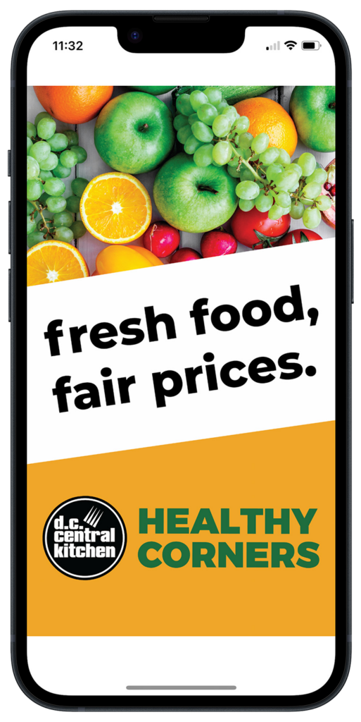
Introducing the Free Healthy Corners Shopper App

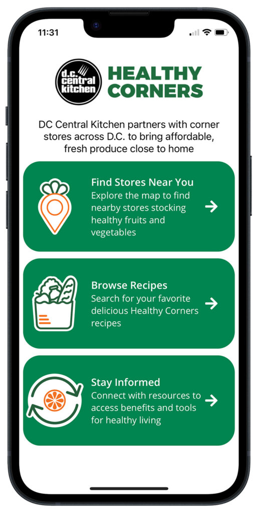
In 2022, DCCK came to Blue Raster with the Healthy Corners Shopper app—originally developed by students at the University of California, Berkley—with the goal to display corner stores in DC neighborhoods that offer fresh, affordable produce to residents through the Healthy Corners program.

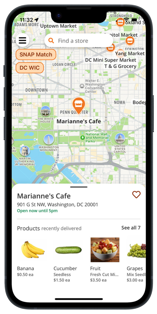
DCCK wanted a user-friendly application that would clearly show customers product availability by location and offer free recipes, resources, and more to inspire better eating. In addition to showing the location of inexpensive produce, the app also notes which stores in the Healthy Corners program offer a “SNAP Match” coupon program for SNAP/EBT customers and/or serve as DC WIC-approved vendors.

An App that Serves Up Real Change

Working off the original application structure, Blue Raster made the Healthy Corners Shopper app production-ready using the cross-platform framework React Native with an innovating backend in Airtable—a low-code platform for building applications.

Since 2020, DCCK’s Healthy Corners program has assisted in selling over 1.2 million units of healthy food options in DC corner stores (Source: https://dccentralkitchen.org/healthy-corners), and the Healthy Corners Shopper app is only helping that number rise. Interested individuals can download the app for free on their Android or iOS device—with exciting, new features coming soon thanks to the continued collaboration of DCCK and Blue Raster.

Strengthening Food Security in DC

Learn more and explore DCCK’s Healthy Corners Shopper app here, or contact Blue Raster today to discuss our hands-on process for creating custom mobile applications.

Exploring Commercial Real Estate from a New Perspective: Blue Raster Partners with AerialSphere

Selecting the right location for a commercial real estate project can be daunting, given the numerous factors that need to be taken into consideration. Often, this is done utilizing an overhead view of properties. Use of an Oriented Imagery Catalog (OIC) from AerialSphere and the Oriented Imagery widget now available from ESRI affords the opportunity to explore properties in an immersive 3D environment.

In this Commercial Real Estate application, Blue Raster:

  • Utilized Open Street Map data from ESRI Living Atlas
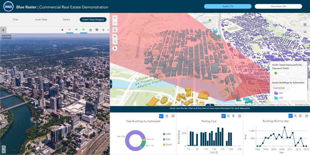
  • Configured multiple filters based on commercial real estate needs - submarket, available square footage, parking cost, and year built
  • Built Dashboard and 3D Scene elements to dynamically reflect filters applied
  • Integrated imagery from AerialSphere to show a point of view from a specific location or floor
  • Generated dynamic viewsheds to illustrate what can be seen from that location
  • Calculated travel time analysis polygons for multiple modes of transportation (both walking and driving)
OIC Oriented Imagery Catalog

Blue Raster configured an ArcGIS Experience Builder application to aid in the exploration of relevant commercial real estate data in a 3D scene.  Utilizing this application, real estate investors can hone in on the properties that meet their needs with specific parameters, and easily traverse the map to further explore the properties.  The integration of 360 degree imagery from AerialSphere provides a more immersive experience, and allows the user the ability to pan, zoom in, zoom out, and explore viewsheds from a given vantage point.  This can make all the difference in understanding the suitability of a site.

While this solution was originally developed to aid in the exploration of commercial real estate properties, this technology can be implemented for a number of other industries. Contact us today to see how we can use this technology in your organization!

Thanks to Kat Clifton and the team at AerialSphere for their collaboration on this case study.

Contact Us

  • This field is for validation purposes and should be left unchanged.

Building Bridges to Progress: The Inter-American Development Bank’s HIT Platform for Infrastructure and Transport

Across Latin America and the Caribbean, the Inter-American Development Bank (IDB) plays a pivotal role in financing sustainable, social, economic, and institutional development. With a mission to support transportation and infrastructure projects across South and Central America, the IDB collaborates with various partners to drive positive change in the region.

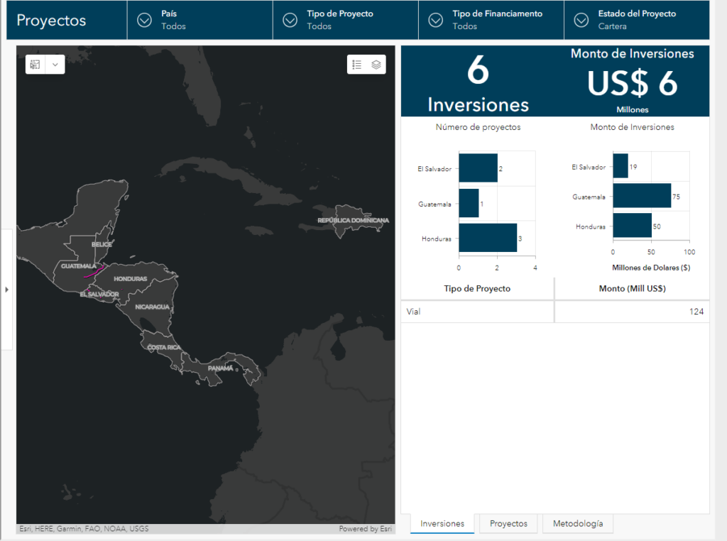
Blue Raster collaborated with the Inter-American Development Bank (IDB) to develop the Hub de Integracion y Transporte (HIT) Platform, a groundbreaking initiative that serves as a regional infrastructure and transport hub, consolidating and presenting crucial information layers for effective planning and decision-making.

IDB HIT Platform

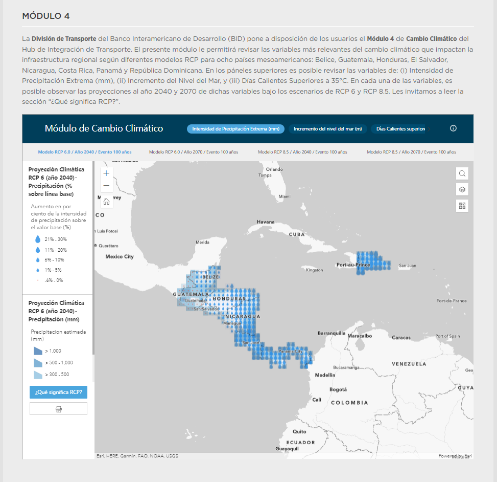
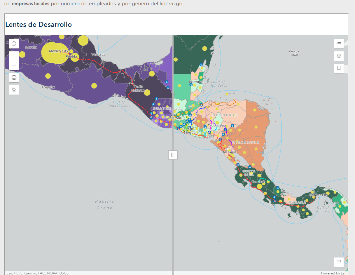
The HIT Platform offers an innovative solution by providing a comprehensive platform that combines key information related to infrastructure, logistics, value chains, projects, climate change, Covid impacts, and development perspectives. This platform acts as a powerful planning tool and an invaluable information repository, catering to the needs of government officials, Mesoamerican stakeholders and IDB specialists. The HIT Project is divided into six modules, each utilizing the robust capabilities of the ArcGIS Online suite of solutions and incorporating custom-developed features to address specific requirements. Recognizing the linguistic diversity of the region, all modules of the HIT Platform were developed in Spanish. The HIT Platform encompasses a series of interactive web applications and dashboards developed with ArcGIS Online and ArcGIS Dashboards.

IDB HIT Platform IDB HIT Platform

The HIT Platform offers a personalized user experience by incorporating customized list and pop-up elements. These interactive components allow users to access specific information related to infrastructure, logistics, and value chains conveniently. By tailoring the user interface to meet specific requirements, the platform enhances usability and efficiency. To enable intuitive data visualization, the HIT platform project utilizes data-driven symbology, a feature within ArcGIS, to dynamically represent information based on various attributes. ArcGIS Arcade expressions, a flexible scripting language within ArcGIS, are employed extensively throughout the HIT project to ensure accurate and consistent data cleaning and formatting. By leveraging Arcade expressions, the platform achieves seamless integration and harmonization of diverse datasets, enhancing data quality and reliability.

Through its effective utilization of ArcGIS Online and its suite of applications and customization options, the HIT Platform sets a benchmark for effective planning and information management in the region, fostering positive change and driving sustainable growth.

Advancing Sustainable Development in West Africa: A Geospatial Toolkit for Monitoring SDG Goals

In 2015, United Nations Member States adopted the 2030 Agenda for Sustainable Development, a shared blueprint for global peace and prosperity now and into the future. Within the core of this agenda are 17 Sustainable Development Goals (SDG) which call all countries to action in a global partnership.

Goal 15 of the Sustainable Development Goals outlines a plan to protect, restore and promote sustainable use of terrestrial ecosystems, sustainably manage forests, combat desertification, and halt and reverse land degradation and biodiversity loss

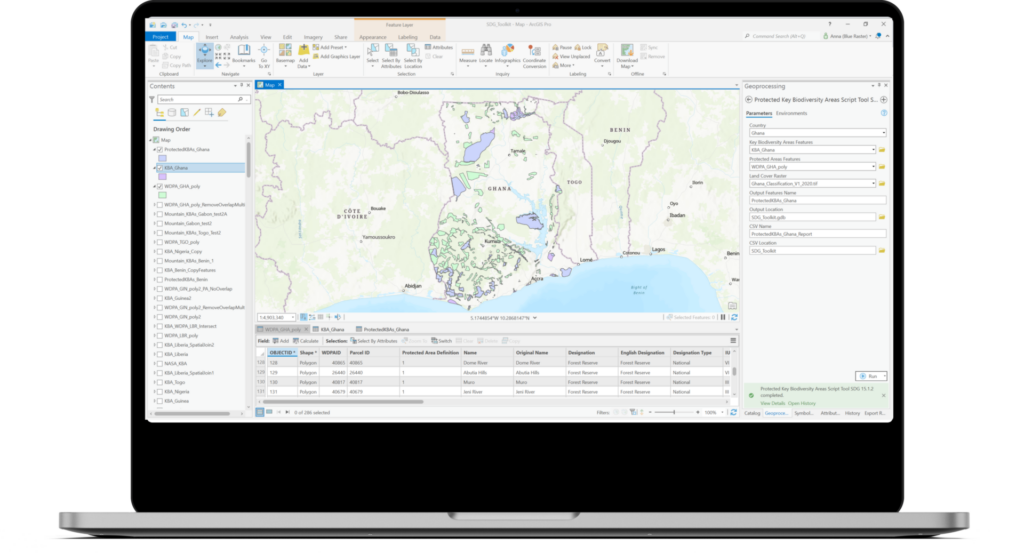
As part of its initiatives in West Africa, the MIT Media Lab partnered with the Biospheric Sciences Lab at NASA Goddard Space Flight Center and Blue Raster to develop a desktop-based geospatial toolkit for calculating and reporting key indicators within Goal 15 of the SDGs. These key indicators are:

  • Forest area as a proportion of total land area
  • Proportion of important sites for terrestrial and freshwater biodiversity that are covered by protected areas, by ecosystem type.
  • Coverage by protected areas of important sites for mountain biodiversity.

Blue Raster developed these tools in a custom toolbox using ArcGIS Pro and the ArcGIS Python site package, ArcPy to calculate the key indicators for countries in the West African region namely: Nigeria, Ghana, Liberia, Togo, Benin, Guinea, and Botswana. The tool leverages remotely sensed imagery and standardized datasets to inform and provide decision making support to West African stakeholders as well as stakeholders within the academic community supporting the UN’s Sustainable Development agenda.

Blue Raster is long time partner of the MIT Media Lab and had previously partnered with the MIT Media Lab and Green Keeper Africa to develop the Lake Nokoué Environmental Observatory application, an online mapping that provides the public with current and historic information about water quality and invasive species in Lake Nokoué. The online observatory and decision support tool utilizes satellite, aerial and ground data to map water quality readings, as well as the location of water hyacinth and a fish farming practice known as “acadja” over time.


Page 1 of 5